
Wienerwald (municipality)
|
Vienna Woods
|
||
|---|---|---|
| coat of arms | Austria map | |
 |
|
|
| Basic data | ||
| Country: | Austria | |
| State : | Lower Austria | |
| Political District : | Mödling | |
| License plate : | MD | |
| Main town : | Sulz in the Vienna Woods | |
| Surface: | 48.54 km² | |
| Coordinates : | 48 ° 6 ′ N , 16 ° 8 ′ E | |
| Height : | 340 m above sea level A. | |
| Residents : | 2,880 (January 1, 2020) | |
| Postal code : | 2392 | |
| Area code : | 02238 or 02258 for Grub | |
| Community code : | 3 17 26 | |
| NUTS region | AT127 | |
| Address of the municipal administration: |
Kirchenplatz 7 2392 Wienerwald |
|
| Website: | ||
| politics | ||
| Mayor : | Michael Krischke ( ÖVP ) | |
|
Municipal Council : ( 2020 ) (21 members) |
||
| Location of Wienerwald in the Mödling district | ||
  |
||
| Source: Municipal data from Statistics Austria | ||

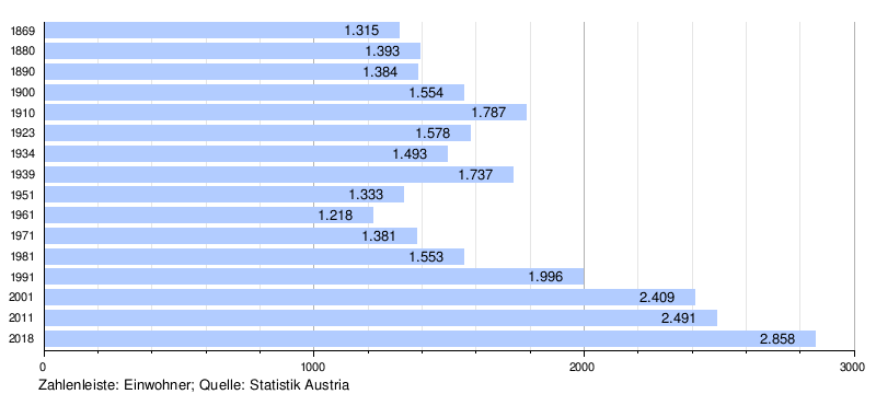
The municipality of Wienerwald is located in the northern part of the Alpine foothills of the same name ( Wienerwald ) in the Mödling district . The community with 2880 inhabitants (as of January 1, 2020) was not created until 1972 as part of the community reform through the amalgamation of the four communities (Dornbach, Grub, Sittendorf and Sulz in the Vienna Woods) and is the largest in area in the Mödling district.
Community structure
According to the Austrian official calendar , the Wienerwald local community includes the cadastral communities
- Dornbach
- Grub
- Sittendorf
- Stangau
- Sulz in the Vienna Woods
The following localities (each village) are (in brackets, population as of January 1, 2020):
- Dornbach (229)
- Buchelbach
- Festleiten
- Lindenhof
-
Grub (605)
- Ameisbühel
- Buchelbach
- Gruberau (144)
- Buchelbach
- Rohrberg
- Sittendorf (662)
- Stangau (231)
- Sulz in the Vienna Woods (860)
- Rohrberg
- Bird pit
- Woggle (149)
![]() Map with all coordinates of the municipality: OSM | WikiMap
Map with all coordinates of the municipality: OSM | WikiMap
|
structure
|
The development of the former municipalities:
- Dornbach
(identical to the cadastral community Dornbach) consists of the village Dornbach, the Rotte Lindenhof, a small part of Buchelbach and the Rotte Festleiten, which is located on the main road in Sulz. The Dornbach is mentioned in 1136 in the foundation book of the Heiligenkreuz Abbey, the place itself for the first time in 1236.
- Sittendorf
(identical to KG Sittendorf) consists of the place Sittendorf and the Rotte Wildegg (with the castle of the same name) and part of Neuweg. First mentioned in 1114 in a Klosterneuburg code. From 1849 to 1920 Dornbach and Sittendorf were united in one municipality, then from 1920 to 1938 and again from 1954 they were independent municipalities.
(identical to KG Grub) consists of the place Grub, the Rotten Ameisbühel (merged with Grub), the Rotte Gföhler and part of Buchelbach . The place is mentioned for the first time in 1254 in a document from the Heiligenkreuz Abbey. In the years 1849 to 1938 and again from 1954 to 1971 Grub was an independent municipality, which celebrated its 700th anniversary in 1955.
The second highest mountain in the Wienerwald community, the Rossgipfel, is located in this cadastral community. The Ross summit is also one of the few mountains in the entire Vienna Woods that has a summit cross and a summit book, but it can only be reached via unmarked paths.
- Sulz in the Vienna Woods - Stangau
Since the founding of communities in the years 1849 to 1933, the cadastral communities Sulz and Stangau were jointly independent as the community Sulz-Stangau . On June 16, 1933, the cadastral community of Stangau separated from Sulz. Renaming of the community of Stangau to Wöglerin was dropped again due to the high costs. Sulz was renamed on March 15, 1935 in Sulz im Wienerwald . 1954 reunited with Stangau as an independent municipality Sulz in the Vienna Woods . Back then it was by far the largest municipality in terms of area and population (in today's municipality).
The village of Stangau consists of the district of Stangau, which has grown together with Sulz, and the districts of Wöglerin, Gruberau and Buchelbach. In the far northwest lies the highest mountain in the municipality (Steinplattl, 649 m).
The villages of Rohrberg and Vogelgraben belong to the village of Sulz in the Vienna Woods. First settlement finds from the 4th century BC BC, first mentioned in 1135 in the foundation book of Heiligenkreuz Abbey . Completely destroyed in 1477 during the occupation of Lower Austria by Matthias Corvinus . It was not settled again until 1590, but was again destroyed during the second Turkish siege in 1683.
- General
From October 15, 1938 to August 31, 1954, all cadastral communities were part of the 24th district of Greater Vienna . On January 1, 1972, all former municipalities and today's cadastral municipalities were combined to form the Wienerwald municipality.
Neighboring communities


| Wolf pit | Breitenfurt near Vienna | |
| Klausen-Leopoldsdorf |
.svg)
|
Kaltenleutenken , Hinterbrühl |
| Alland | Heiligenkreuz | Gaaden |
history
On August 6, 1981, a jet aircraft of the Federal Army of the Saab 105 Ö type (Lfz GI-19 S.Nr .: 105419) crashed in Grub. The jet crashed into the home of Karl Musil , solo dancer at the Vienna State Opera . The artist, his wife and two children were badly burned. The two pilots Major Alois Strahner and Lieutenant Gerhard Wiesinger were killed.
Population development
economy
The population, mainly living from agriculture, has switched to horse breeding and keeping. This also created tourism. Many second home owners from Vienna have settled here.
traffic
In terms of traffic, it can only be reached by road with the public bus from Mödling and Vienna - Liesing , although there are only limited connections from the early evening. The lines are part of the Verkehrsverbund Ost-Region . The Vienna outer ring motorway A 21 is very close to Grub and Sittendorf and has a junction together with Heiligenkreuz .
tourism
- National Moto Cross races take place in Sittendorf every year . World championship races used to be held.
- The small community offers a variety of hiking trails and there are several restaurants in each village.
- Wildegg Castle should be mentioned as a sight .
- The motorcycle museum Waldmann Collection is also located in Sulz in the Vienna Woods. 2000 exhibits will be shown, 100 of them motorcycles of various brands and types from the years 1904 to 1978; Motors and accessories; Literature and posters.
- In the Vienna Woods there are only two mountains with a summit cross and a summit book, both are in the Wienerwald municipality. These are the Steinplattl (649 m, highest elevation in the community in the extreme northwest of the community (KG Stangau)) and the Rossgipfel (633 m, KG Grub). Both mountains cannot be reached via marked paths and do not offer any views as they are forested.

Church of Sittendorf; remarkable is the heptagonal tower

Church in Sulz with the Franz Joseph Memorial Oak

Church in Sulz

Wildegg Castle near Sittendorf


See also
literature
- Wilhelm Rausch (Ed.), Hermann Rafetseder (Ed.): Area and name changes of the municipalities of Austria since the middle of the 19th century . Research on the history of cities and markets in Austria, Volume 2. Landesverlag, Linz (an der Donau) 1989, ISBN 3-900387-22-2 .
- Part 4: Municipalities - Lower Austria - 538th Vienna Woods . In: Austrian official calendar online . Jusline Österreich GmbH (Verlag Österreich), Vienna 2002–, ZDB -ID 2126440-5 .
Web links
- 31726 - Vienna Woods. Community data, Statistics Austria .
Individual evidence
- ↑ a b Part 4: Municipalities - Lower Austria - 538th Vienna Woods . In: Austrian official calendar online , accessed on October 30, 2015.
- ↑ Statistics Austria: Population on January 1st, 2020 by locality (area status on January 1st, 2020) , ( CSV )
- ↑ a b Rausch et al .: Area and Name Changes , p. 343.
- ^ Wienerwald community
Remarks
-
↑ The name Grub in the Vienna Woods is not the official name, but it is used to make the location easier to find in maps and histories. The independent community, which has existed (again) since September 1, 1954, has always carried the name Grub . - See: Wilhelm Rausch (Hrsg.), Hermann Rafetseder (edit.): Area and name changes of the municipalities of Austria since the middle of the 19th century . Research on the history of cities and markets in Austria, Volume 2. Landesverlag, Linz (an der Donau) 1989, ISBN 3-900387-22-2 , pp. 333, 336, 342 f. and
part 4: Municipalities - Lower Austria - 538th Vienna Woods . In: Austrian official calendar online . Jusline Österreich GmbH (Verlag Österreich), Vienna 2002–, ZDB -ID 2126440-5 , accessed on October 30, 2015.

Achau | Biedermannsdorf | Breitenfurt near Vienna | Brunn am Gebirge | Gaaden | Giesshübl | Gumpoldskirchen | Guntramsdorf | Hennersdorf | Hinterbrühl | Cold people | Laab in the forest | Laxenburg | Maria Enzersdorf | Mödling | Münchendorf | Perchtoldsdorf | Vösendorf | Wiener Neudorf | Vienna Woods
Cadastral communities: Dornbach | Grub | Sittendorf | Stangau | Vienna Woods
Locations: Dornbach | Grub | Gruberau | Sittendorf | Stangau | Sulz in the Vienna Woods | Woggle
Villages: Dornbach | Grub | Sittendorf | Stangau | Sulz in the Vienna Woods | Wöglerin Rotten: Ameisbühel | Buchelbach | Festleit | Frotzenberg | Gföhler | Gruberau | Lindenhof | Rohrberg | Vogelgraben Other locations: Wildegg Castle
Counting district: Sulz im Wienerwald | Dornbach | Grub | Sittendorf