
Giesshübl
|
Giesshübl
|
||
|---|---|---|
| coat of arms | Austria map | |
 |
|
|
| Basic data | ||
| Country: | Austria | |
| State : | Lower Austria | |
| Political District : | Mödling | |
| License plate : | MD | |
| Surface: | 3.91 km² | |
| Coordinates : | 48 ° 6 ' N , 16 ° 14' E | |
| Height : | 416 m above sea level A. | |
| Residents : | 2,378 (Jan 1, 2020) | |
| Population density : | 608 inhabitants per km² | |
| Postal code : | 2372 | |
| Area code : | 02236 | |
| Community code : | 3 17 07 | |
| NUTS region | AT127 | |
| Address of the municipal administration: |
Hauptstrasse 73 2372 Gießhübl |
|
| Website: | ||
| politics | ||
| Mayor : | Helmut Kargl (list of ÖVP) | |
|
Municipal Council : ( 2020 ) (19 members) |
||
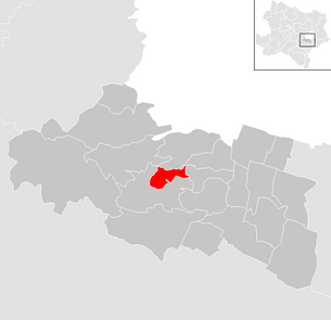
| Location of Gießhübl in the Mödling district | ||
  |
||
 Gießhübl with a view over Vienna |
||
| Source: Municipal data from Statistics Austria | ||

Gießhübl is a municipality with 2378 inhabitants (as of January 1, 2020) in the Mödling district in Lower Austria . It is located south of the Austrian capital Vienna on the edge of the Föhrenberge nature reserve at 416 m above sea level and is therefore also the highest wine village in Lower Austria.
geography
Gießhübl was previously a purely agricultural place, today it is mainly a residential community. This was also favored by its location in the immediate vicinity of Vienna and with a direct connection to the A 21 ( Vienna outer ring motorway ). Gießhübl consists of the village of Gießhübl, which also includes the village of Hochleiten.
Adjacent communities
| Perchtoldsdorf | Brunn am Gebirge | |
| Hinterbrühl |
.svg)
|
Maria Enzersdorf |
| Hinterbrühl |
A new neighborhood was created in 2012 through an exchange of territory between Perchtoldsdorf and Kaltenleutbaren on the order of 58 hectares . Perchtoldsdorf now borders Weissenbach (Hinterbrühl) over a length of about 300 meters, while Gießhübl lost the common border with Kaltenleutgabe.
history
The place emerged from a settlement founded in 1592 with rural structures.
In the period between 1938 and 1954, Gießhübl, like 96 other municipalities in Lower Austria, belonged to Greater Vienna , which at that time comprised 26 districts and was part of the 24th district, Mödling. It was not until 1954 that Gießhübl became an independent municipality in the province of Lower Austria again, which was celebrated in September 2004 with a big 50th anniversary.
Population development
| census | Residents |
|---|---|
| 2011 | 2111 |
| 2001 | 1597 |
| 1991 | 1609 |
| 1981 | 1459 |
| 1971 | 975 |
Source: Gießhübl population development. (PDF) Statistics Austria
Culture and sights

- Roman Catholic Parish church hl. Trinity ; a basilica with Heimatstil elements, which was built around 1900.
politics
Mayor of the community is Helmut Kargl ( L.ÖVP ), Vice Mayor Martin Klicpera ( GREEN ), Head of Department Silvia Krippl.
In the council there are a total of 21 seats after the local elections in Lower Austria in 2020 following distribution of seats : List ÖVP 9, List GREEN 5, Bürgerliste Lebenswertes Gießhübl 4, list SPÖ 3
coat of arms
Blazon : "In a split shield above a black three-mountain towering in the base of the shield, in front a silver cross in blue, behind in gold a green spruce with the same trunk". It was awarded to the municipality in 1977.
Economy and Infrastructure
In 2001 there were 91 non-agricultural workplaces, agricultural and forestry operations 14 according to the 1999 survey. The number of people in work at the place of residence was 730 according to the 2001 census. In 2001 the activity rate was 48.02 percent.
Pouring walls

In the west of the village, behind the Hans-Nemecek hut (524 m above sea level), there are some rocky eruptions that are used as a climbing garden and as a practice area. They are called "pouring walls" and can be reached in about 15 minutes on foot from the terminus of the bus routes from Vienna-Liesing (bus 256) and Mödling train station (bus 262).
societies
- Karl Theater Gießhübl
- 1. FC Giesshübl
- Association of the music school in Gießhübl
Web links
- 31707 - Giesshübl. Community data, Statistics Austria .
- Community of Gießhübl
Historical maps
- The area of Gießhübl in the regional surveys from approx. 1789 to 1910
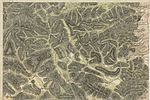
Gießhübl (right, center) and its surroundings around 1780, Josephinische Landesaufnahme
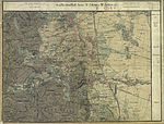
Gießhübl (left, center) and its surroundings around 1872 (recording sheet of the state survey)


Individual evidence

Achau | Biedermannsdorf | Breitenfurt near Vienna | Brunn am Gebirge | Gaaden | Giesshübl | Gumpoldskirchen | Guntramsdorf | Hennersdorf | Hinterbrühl | Cold people | Laab in the forest | Laxenburg | Maria Enzersdorf | Mödling | Münchendorf | Perchtoldsdorf | Vösendorf | Wiener Neudorf | Vienna Woods
Cadastral communities: Gießhübl
Locations: Gießhübl
Villages: Gießhübl | Hochleiten
Counting district: Gießhübl