
List of highways in Sierra Leone

This is a list of major highways in Sierra Leone .
background
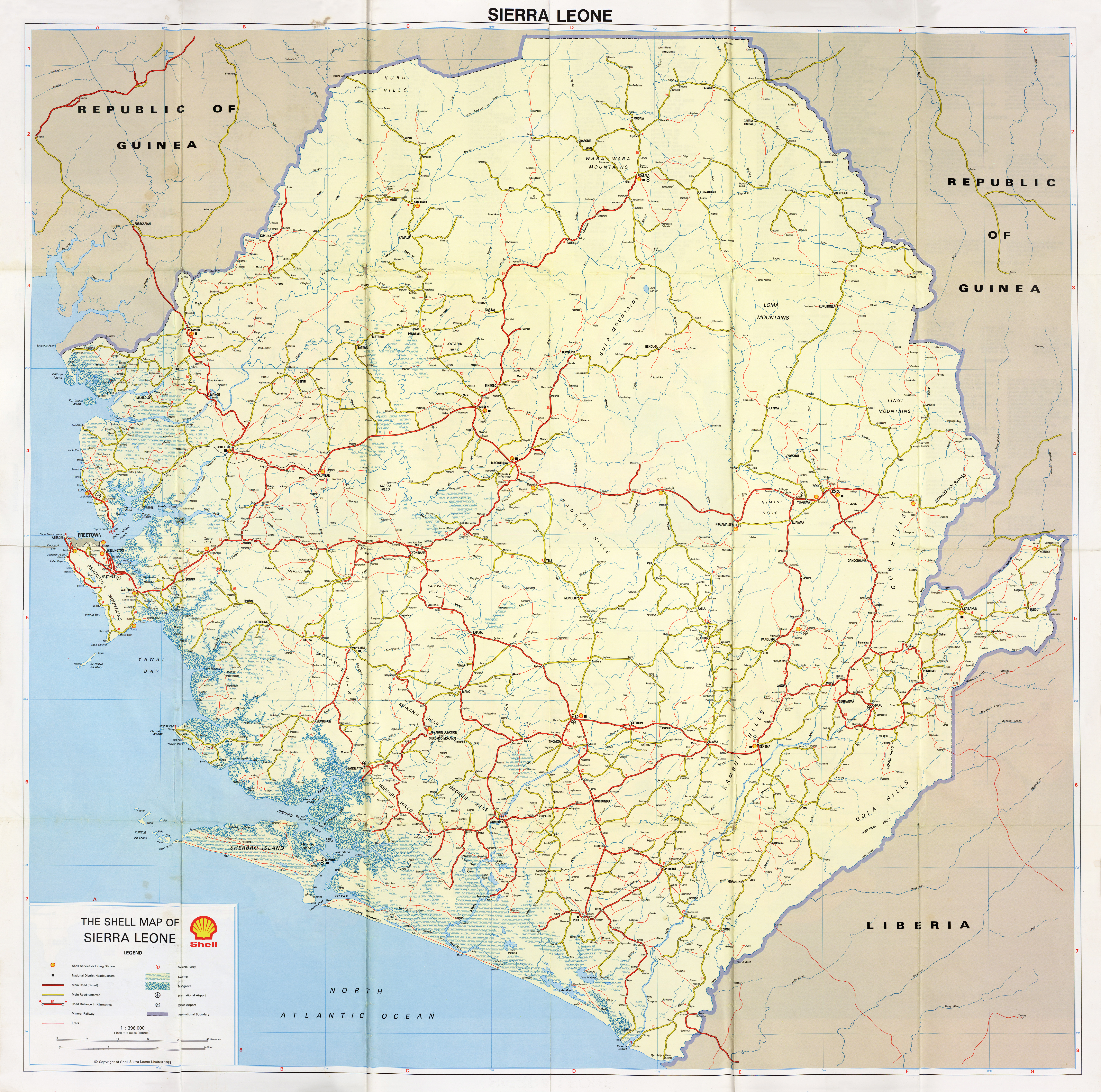
The entire Sierra-Leonean road network is 11,555, 11,700 or 11,999 kilometers long and the majority (91 percent) is unpaved. There are no highways (see Autobahn ), although a first highway has been built between Masiaka and Wellington since 2016. This is financed by the People's Republic of China and refinanced through a toll .
history
The first road construction began around 1918, with only individual localities being connected until 1926, especially in what is now Proving Southern . From 1961, far-reaching district connections were built between all the important towns in the country.
Road types
- A-roads are major trunk roads (trunk roads) connecting the capital Freetown with the provincial capitals and other important localities. In 2009, 925 of the 2332 kilometers of roads of this type were asphalted.
- B-roads are connecting roads that mainly connect smaller towns with each other and enable connections to the A-roads. In 2009, only 46 of the 2019 total kilometers were paved.
- F-roads are smaller connecting roads ( English feeder roads ). They are unpaved over their entire length of 4277 kilometers (as of 2009)
- Roads in built-up areas (cities, villages, etc.). In 2009 there were 3,000 kilometers of this, of which only 80 kilometers are asphalt.
Currently (as of 2016), the asphalting and road construction is the same as in 2009. 8555 kilometers are recorded in the National Road System .
Streets are not numbered. The streets are mostly named after endpoints, for example Freetown – Waterloo .
A-roads (trunk roads)
| End point 1 | Important places (intermediate stations) |
End point 2 | Road type | length |
|---|---|---|---|---|
| Freetown |
Waterloo Masiaka |
Lunsar | asphalted | |
| Lunsar |
Port Loko Kambia |
Pamelao (border to Guinea ) | asphalted | |
| Lunsar | Makeni | Kabala | asphalted | |
| Masiaka | Mile 91 | asphalted | ||
| Mile 91 |
Moyamba Bo Kenema |
Hanga | asphalted | |
| Bo | Bandajuma | asphalted | ||
| Freetown | Freetown Peninsula | Freetown | asphalted | |
| Cambia | Kamakwie | not paved | ||
| Kabala |
Falaba Bendugu Kurubonia Kayiam Koidu / Sefadu Bunumbu Segbwema |
Hanga | not paved | |
| Koindu |
Buedu Kailahun Pendembu Daru Joru Zimmi |
Mano border post (border to Liberia ) | not paved | |
| Daru | Segbwema | not paved | ||
| Mile 91 |
Magburaka Yele |
Bo | not paved | |
| Lungi | Pepel and Port Loko | not paved | ||
| Magbuntuso |
Rotifunk Bauya Moyamba |
Moyamba Junction | not paved |
Transnational roads
literature
- Government of the Republic of Sierra Leone (Ed.): Integrated Transport Policy, Strategy and Investment Plan , 2013 ( PDF )
- African Development Bank (Ed.): Infrastructure and Growth in Sierra Leone , African Development Bank Group, Tunisia 2011 ( PDF )
- Nataliya Pushak, Vivien Foster: Sierra Leone's Infrastructure - A Continental Perspective , The World Bank, June 2011 ( PDF )
- Sara Bech Padrosa: Infrastructures in Africa: Analysis and evolution of the road network in Sierra Leone , Universitat Politècnica de Catalunya, July 2009 ( PDF ).
Web links
Individual evidence
- ↑ African Development Bank (ed.): Infrastructure and Growth in Sierra Leone , African Development Bank Group, Tunisia 2011, p. 49
- ↑ a b Sara Bech Padrosa: Infrastructures in Africa: Analysis and evolution of the road network in Sierra Leone , Polytechnic University of Catalonia, July 2009, p 50f.
- ↑ a b Nataliya Pushak, Vivien Foster: Sierra Leone's Infrastructure A Continental Perspective , The World Bank, June 2011, p. 20
- ^ Sierra Leone Road Network (main roads). WFPGeoNode / World Food Program. Retrieved January 11, 2018.
- ↑ CRSG will complete first phase of Wellington - Masiaka Rd before rains. Awoko, March 28, 2017.
- ↑ CRSG says Wellington-Masiaka Highway will be the best. Awoko, March 19, 2016.
- ↑ Sara Bech Padrosa: Infrastructures in Africa: Analysis and evolution of the road network in Sierra Leone , Polytechnic University of Catalonia, July 2009, p. 48
- ↑ Sara Bech Padrosa: Infrastructures in Africa: Analysis and evolution of the road network in Sierra Leone , Polytechnic University of Catalonia, July 2009, p. 67
- ↑ 2.3 Sierra Leone Road Assessment. Logistics Capacity Assessments, March 15, 2016.
- ^ The Shell Map of Sierra Leone. Shell Sierra Leone Limited, 1988.
.svg)
Egypt | Algeria | Angola | Equatorial Guinea | Ethiopia | Benin | Botswana | Burkina Faso | Burundi | Djibouti | Ivory Coast | Eritrea | Eswatini | Gabon | Gambia | Ghana | Guinea | Guinea-Bissau | Cameroon | Cape Verde | Kenya | Comoros | Congo (Dem. Rep.) | Congo, Republic of | Lesotho | Liberia | Libya | Madagascar | Malawi | Mali | Morocco | Mauritania | Mauritius | Mozambique | Namibia | Niger | Nigeria | Rwanda | Zambia | São Tomé and Príncipe | Senegal | Seychelles | Sierra Leone | Zimbabwe | Somalia | South Africa | Sudan | South Sudan | Tanzania | Togo | Chad | Tunisia | Uganda | Central African Republic
List of highways of the states of:
Africa |
Asia |
Australia and Oceania |
Europe |
North America |
South America