| Surname
|
image
|
Identifier
|
details
|
position
|
Area
hectares
|
date
|
Laucherttal with side valleys 
|

|
4.15.002
WDPA: 322538
|
Trochtelfingen , Sonnenbühl
Charming Alb valley with meanders, wooded collapsing and sliding slopes and pastures.
|
⊙
|
213.0
|
1955-09-13
|
|
Coal mine
|

|
4.15.003
WDPA: 322253
|
Reutlingen
bird protection tree.
|
⊙
|
1.3
|
1955-11-08
|
|
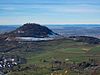
Georgenberg
|

|
4.15.004
WDPA: 321056
|
Pfullingen A
volcanic vent between Reutlingen and Pfullingen. Preserved rock debris in the chimney and basalt tuff deposits. Rich steppe heather flora.
|
⊙
|
7.3
|
1958-07-10
|
|
Achalm
|
|
4.15.005
WDPA: 319429
|
Eningen unter Achalm , Reutlingen
Zeugenberg in the Achalmgraben and Reutlingen's landmark. With deciduous forest knoll and sheep pastures. Popular hiking destination with a wonderful panoramic view from the tower of the ruin.
|
⊙
|
66.6
|
1958-10-31
|
|
Schönbuch
|

|
4.15.009
WDPA: 7027
|
Pliezhausen , Reutlingen , Walddorfhäslach Coherent
community forest of the mentioned communities. Designation as a nature park is imminent.
|
⊙
|
1,130.0
|
1961-12-01
|
|
Neckar valley between Tübingen and Plochingen
|

|
4.15.010
WDPA: 323156
|
Pliezhausen , Reutlingen
Neckartal with the mostly wooded slopes and smaller side valleys, partly already defaced by gravel pits.
|
⊙
|
207.0
|
1963-01-23
|
|
Behind Gleinsgelesberg
|
BW
|
4.15.013
WDPA: 321620
|
Hayingen , Pfronstetten
Summer sheep pasture with juniper.
|
⊙
|
6.2
|
1955-05-31
|
|
Klessenbergtrieb
|
BW
|
4.15.014
WDPA: 322193
|
Hayingen , Pfronstetten
Summer sheep pasture with juniper.
|
⊙
|
12.9
|
1955-05-31
|
|
Fuchslochhalde, Ruckenhalde, Steighalde
|
BW
|
4.15.015
WDPA: 320917
|
Pfronstetten
summer sheep pasture with juniper.
|
⊙
|
56.8
|
1955-05-31
|
|
Vöhrensteig
|
BW
|
4.15.016
WDPA: 325437
|
Pfronstetten
summer sheep pasture with juniper.
|
⊙
|
10.5
|
1955-05-31
|
|
May valleys
|
BW
|
4.15.017
WDPA: 322882
|
Pfronstetten
summer sheep pasture with juniper.
|
⊙
|
0.9
|
1955-05-31
|
|
Ehestetter Buckel (Schaiwiesen)
|
BW
|
4.15.018
WDPA: 320528
|
Pfronstetten
summer sheep pasture with juniper.
|
⊙
|
1.1
|
1955-05-31
|
|
Summer sheep pasture behind Feilhau
|
BW
|
4.15.019
WDPA: 324655
|
Pfronstetten
|
⊙
|
4.7
|
1955-05-31
|
|
Summer sheep pasture in Zwiesel and Au
|
BW
|
4.15.020
WDPA: 324683
|
Pfronstetten
|
⊙
|
2.0
|
1955-05-31
|
|
Hedge landscape above the dump
|
BW
|
4.15.024
WDPA: 321483
|
Münsingen
|
⊙
|
10.0
|
1955-05-31
|
|
Hedge landscape in the cabbage
|
BW
|
4.15.025
WDPA: 321476
|
Münsingen
|
⊙
|
4.0
|
1955-05-31
|
|
To Unsang and Birkenschächle
|
BW
|
4.15.026
WDPA: 319714
|
Hohenstein
summer sheep pasture and hardwood bushes.
|
⊙
|
10.0
|
1955-05-31
|
|
Summer sheep pasture on Hagbühl
|
BW
|
4.15.027
WDPA: 324631
|
Münsingen
|
⊙
|
9.0
|
1955-05-31
|
|
Summer sheep pasture on Breitelau
|
BW
|
4.15.028
WDPA: 324623
|
Münsingen
|
⊙
|
15.0
|
1955-05-31
|
|
Summer sheep pasture on the Pfaffenburren
|
BW
|
4.15.030
WDPA: 324616
|
Münsingen
|
⊙
|
8.0
|
1955-05-31
|
|
Summer sheep pasture on the Lau
|
BW
|
4.15.033
WDPA: 324626
|
Roman stone
|
⊙
|
6.0
|
1955-05-31
|
|
Summer sheep pasture in the Bental
|
BW
|
4.15.034
WDPA: 324659
|
Roman stone
|
⊙
|
3.0
|
1955-05-31
|
|
Summer sheep pasture in Lindenhalde and Wiesensteigtrieb
|
BW
|
4.15.037
WDPA: 324682
|
Münsingen
|
⊙
|
3.0
|
1955-05-31
|
|
Summer sheep pasture on Ohl
|
BW
|
4.15.047
WDPA: 324641
|
Roman stone
|
⊙
|
3.0
|
1955-05-31
|
|
Summer sheep pasture behind the crouching stone, Auchtweide
|
BW
|
4.15.048
WDPA: 324653
|
Roman stone
|
⊙
|
16.0
|
1955-05-31
|
|
Summer sheep pasture on Hochbucher Weg
|
BW
|
4.15.049
WDPA: 324609
|
Roman stone
|
⊙
|
5.0
|
1955-05-31
|
|
Ringelesberg
|
BW
|
4.15.051
WDPA: 323897
|
Hohenstein
summer sheep pasture with juniper.
|
⊙
|
4.0
|
1955-05-31
|
|
Bubble Mountain and Saalhau
|
BW
|
4.15.052
WDPA: 319966
|
Hohenstein
|
⊙
|
16.0
|
1955-05-31
|
|
Summer sheep pasture in Buchhausen
|
BW
|
4.15.053
WDPA: 324672
|
Hohenstein
|
⊙
|
4.0
|
1955-05-31
|
|
Summer sheep pasture on Galgenberg
|
BW
|
4.15.054
WDPA: 324607
|
Hohenstein
|
⊙
|
3.0
|
1955-05-31
|
|
Summer sheep pasture on Rauhberg
|
BW
|
4.15.055
WDPA: 324642
|
Hohenstein
|
⊙
|
5.0
|
1955-05-31
|
|
Summer sheep pasture on Linsenberg and Bienenwäldle
|
BW
|
4.15.056
WDPA: 324638
|
Hohenstein
|
⊙
|
5.0
|
1955-05-31
|
|
Summer sheep pasture on Schwendeberg
|
BW
|
4.15.057
WDPA: 324644
|
Hohenstein
|
⊙
|
14.0
|
1955-05-31
|
|
Summer sheep pasture on Sandberg, Silberberg and in front of the Brömes
|
BW
|
4.15.060
WDPA: 324643
|
Hayingen
|
⊙
|
55.0
|
1955-05-31
|
|
Summer sheep pasture on stable book
|
BW
|
4.15.061
WDPA: 324645
|
Hayingen
|
⊙
|
4.0
|
1955-05-31
|
|
Summer sheep pasture on Hilbertswiese
|
BW
|
4.15.062
WDPA: 324633
|
Hayingen
|
⊙
|
15.0
|
1955-05-31
|
|
Summer sheep pasture on high heap
|
BW
|
4.15.063
WDPA: 324634
|
Hayingen
|
⊙
|
13.0
|
1955-05-31
|
|
Summer sheep pasture on Maiersberg
|
BW
|
4.15.064
WDPA: 324639
|
Hayingen
|
⊙
|
4.0
|
1955-05-31
|
|
Summer sheep pasture behind the heap
|
BW
|
4.15.065
WDPA: 324654
|
Hayingen
|
⊙
|
5.0
|
1955-05-31
|
|
Desolation on Gleißenberg
|
BW
|
4.15.066
WDPA: 323437
|
Hayingen
|
⊙
|
7.0
|
1955-05-31
|
|
Summer sheep pasture in the white fields
|
BW
|
4.15.067
WDPA: 319820
|
Double folds
|
⊙
|
8.0
|
1955-05-31
|
|
Summer sheep pasture on Hagnau
|
BW
|
4.15.068
WDPA: 324632
|
Double folds
|
⊙
|
10.0
|
1955-05-31
|
|
Summer sheep pasture in the donkey pasture
|
BW
|
4.15.069
WDPA: 324678
|
Double folds
|
⊙
|
1.0
|
1955-05-31
|
|
Summer sheep pasture in the Banholz
|
BW
|
4.15.070
WDPA: 324656
|
Double folds
|
⊙
|
11.0
|
1955-05-31
|
|
Summer sheep pasture in the Mittelberg
|
BW
|
4.15.071
WDPA: 324669
|
Double folds
|
⊙
|
6.0
|
1955-05-31
|
|
Summer sheep pasture on Fleckenhau
|
BW
|
4.15.072
WDPA: 324605
|
Double folds
|
⊙
|
1.0
|
1955-05-31
|
|
Summer sheep pasture in the Grastel
|
BW
|
4.15.073
WDPA: 324667
|
Double folds
|
⊙
|
3.0
|
1955-05-31
|
|
Summer sheep pasture in Fußenäcker
|
BW
|
4.15.074
WDPA: 324680
|
Double folds
|
⊙
|
5.0
|
1955-05-31
|
|
Summer sheep pasture on hunger walls
|
BW
|
4.15.075
WDPA: 324636
|
Pfronstetten
|
⊙
|
13.0
|
1955-05-31
|
|
Desolation on the Schloßburren
|
BW
|
4.15.076
WDPA: 323439
|
Pfronstetten
|
⊙
|
1.0
|
1955-05-31
|
|
Barren "Round Burren"
|
BW
|
4.15.080
WDPA: 323436
|
Hayingen
|
⊙
|
3.0
|
1955-05-31
|
|
Desolation in the tub
|
BW
|
4.15.085
WDPA: 323442
|
Hayingen
|
⊙
|
3.0
|
1955-05-31
|
|
Summer sheep pasture on Hohengreutter
|
BW
|
4.15.086
WDPA: 324635
|
Hayingen
|
⊙
|
4.0
|
1955-05-31
|
|
Summer sheep pasture in the book
|
BW
|
4.15.088
WDPA: 324661
|
Bad Urach
|
⊙
|
6.0
|
1955-05-31
|
|
Summer sheep pasture in the book
|
BW
|
4.15.089
WDPA: 324660
|
Pfronstetten
|
⊙
|
4.0
|
1955-05-31
|
|
Summer sheep pasture on the Tobelburren
|
BW
|
4.15.090
WDPA: 324618
|
Pfronstetten
|
⊙
|
9.0
|
1955-05-31
|
|
Birch pasture above the Warth
|
BW
|
4.15.091
WDPA: 319956
|
Pfronstetten
|
⊙
|
2.0
|
1955-05-31
|
|
Summer sheep pasture on Irnestal and Guckenbühl
|
BW
|
4.15.095
WDPA: 324637
|
Mehrstetten
|
⊙
|
13.0
|
1955-05-31
|
|
Summer sheep pasture on Marksteigle
|
BW
|
4.15.098
WDPA: 324640
|
Mehrstetten
|
⊙
|
3.0
|
1998-02-04
|
|
Summer sheep pasture in the Banntal
|
BW
|
4.15.099
WDPA: 324657
|
Mehrstetten
|
⊙
|
13.0
|
1955-05-31
|
|
Summer sheep pasture in the Upper and Lower Böttental and Vorderen Berg
|
BW
|
4.15.100
WDPA: 324674
|
Mehrstetten
|
⊙
|
16.0
|
1955-05-31
|
|
Summer sheep pasture under construction, Ofenbuckel and Butzenbuch
|
BW
|
4.15.102
WDPA: 324658
|
Hohenstein
|
⊙
|
29.0
|
1995-05-15
|
|
Summer sheep pasture on the Krähenberg
|
BW
|
4.15.103
WDPA: 324613
|
Hayingen
|
⊙
|
21.0
|
1955-05-31
|
|
Summer sheep pasture in Buchhausen
|
BW
|
4.15.104
WDPA: 324672
|
Hayingen
|
⊙
|
8.0
|
1955-05-31
|
|
Summer sheep pasture on Burgstall and Milchberg
|
BW
|
4.15.107
WDPA: 324624
|
Hohenstein
|
⊙
|
8.0
|
1996-05-10
|
|
Summer sheep pasture in Kappellenäcker
|
BW
|
4.15.108
WDPA: 324681
|
Hohenstein
|
⊙
|
5.0
|
1955-05-31
|
|
Summer sheep pasture in the Weidental
|
BW
|
4.15.109
WDPA: 324671
|
Hohenstein
|
⊙
|
26.0
|
1955-05-31
|
|
Summer sheep pasture in the Pentecostal wood
|
BW
|
4.15.110
WDPA: 324670
|
Hohenstein
|
⊙
|
5.0
|
1955-05-31
|
|
Summer sheep pasture Kleiner Kapf und Tal, summer sheep pasture in Heinach
|
BW
|
4.15.111
WDPA: 324684
|
Pfronstetten
|
⊙
|
32.0
|
1955-05-31
|
|
Summer sheep pasture on Elwangen (Urenbühl)
|
BW
|
4.15.112
WDPA: 324630
|
Münsingen
|
⊙
|
4.0
|
1955-05-31
|
|
Desert in the Hartberg
|

|
4.15.113
WDPA: 323441
|
Bad Urach
|
⊙
|
11.0
|
1955-05-31
|
|
Desert and summer sheep pasture under the Ernstfeld
|
BW
|
4.15.114
WDPA: 323443
|
Bad Urach
|
⊙
|
9.0
|
1955-05-31
|
|
Summer sheep pasture in the Löhle
|
BW
|
4.15.115
WDPA: 324668
|
Double folds
|
⊙
|
2.0
|
1955-05-31
|
|
Summer sheep pasture on the Fetzenried
|
BW
|
4.15.116
WDPA: 324604
|
Pfronstetten
|
⊙
|
8.0
|
1955-05-31
|
|
Summer sheep pasture on Eichholz
|
BW
|
4.15.117
WDPA: 324601
|
Münsingen
|
⊙
|
12.0
|
1955-05-31
|
|
Summer sheep pasture on book heaps
|
BW
|
4.15.118
WDPA: 324620
|
Trochtelfingen
|
⊙
|
9.0
|
1955-05-31
|
|
Desert at the Mägerkinger Häule
|
BW
|
4.15.119
WDPA: 323438
|
Trochtelfingen
|
⊙
|
3.0
|
1955-05-31
|
|
Summer sheep pasture in the Spitzäckern
|
BW
|
4.15.120
WDPA: 324676
|
Trochtelfingen
|
⊙
|
3.0
|
1955-05-31
|
|
Waldkopf east of the Hohenwittlingen ruins
|
BW
|
4.15.121
WDPA: 325612
|
Bad Urach
|
⊙
|
3.0
|
1955-05-31
|
|
Brunnhalde south of Hof Hohenwittlingen
|

|
4.15.122
WDPA: 320130
|
Bad Urach
|
⊙
|
1.0
|
1955-05-31
|
|
Wolfsschlucht
|
BW
|
4.15.123
WDPA: 325934
|
Bad Urach
|
⊙
|
3.0
|
1955-05-31
|
|
Summer sheep pasture on the Halden
|
BW
|
4.15.124
WDPA: 324628
|
Roman stone
|
⊙
|
6.0
|
1955-05-31
|
|
Glass valley
|
BW
|
4.15.125
WDPA: 321088
|
Hayingen , Zwiefalten
Typical Alb valley, source of the Aach, many rock areas in the White Jura.
|
⊙
|
120.0
|
1958-07-22
|
|
Tobeltal
|
BW
|
4.15.126
WDPA: 325183
|
Zwiefalten
dry valley of the Alb with many beautiful rock areas. Ice age meltwater channel during the greatest extent of the ice. In the lower part the Kesselbach spring.
|
⊙
|
36.0
|
1958-07-24
|
|
Fischburgtal
|
BW
|
4.15.127
WDPA: 320814
|
Bad Urach
A very attractive water-bearing valley on the Neckar side of the Swabian Alb; beautiful rock areas.
|
⊙
|
136.0
|
1961-04-18
|
|
Trochtelfinger Heide and Seckachtal
|
BW
|
4.15.128
WDPA: 325236
|
Trochtelfingen , Engstingen , Hohenstein
Typical high alpine landscape with dry valleys and mountain peaks; Island of calm; Plant protection area.
|
⊙
|
808.5
|
1966-09-19
|
|
Grafenberg
|

|
4.15.129
WDPA: 321141
|
Grafenberg
old volcanic vent.
|
⊙
|
2.7
|
1965-10-28
|
|
Riedlinger Alb
|
BW
|
4.15.130
WDPA: 323885
|
Zwiefalten
Alb plateau with dry valleys and mountain peaks, in the southern part of the White Jura there are molasse layers; Ice Age meltwater channels.
|
⊙
|
1,353.0
|
1940-09-25
|
|
Willow in the Wannenhalde
|
BW
|
4.15.133
WDPA: 325690
|
Münsingen
summer sheep pasture.
|
⊙
|
7.0
|
1955-05-31
|
|
Great Lautertal
|

|
4.15.134
WDPA: 321199
|
Gomadingen , Hayingen , Münsingen , Engstingen
Typical Alb valley on the Danube side with meadow meanders, hillside forests and rocks; Recreation area.
|
⊙
|
9,885.9
|
2004-04-05
|
|
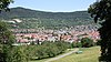
Reutlinger and Uracher Alb
|

Urach waterfall
|
4.15.135
WDPA: 323829
|
Dettingen an der Erms , Eningen under Achalm , Grabenstetten , Grafenberg
Albtrauf of the Ermstal and east of the Echaztal with the adjoining plateaus of the Swabian Alb and the valleys of the Zellertal and Argenbachtal with Übersberg, Eninger Weide, Glanzer Roßberg, Uracher waterfall, Runder Berg, Hannerfels and Schorrenfels, slopes of the five valleys around Urach with Etzenberg, Hinteres Wachtertal, Sommerberg, Hofwald, Hofbühl, Metzinger Weinberg and Florian. Rare flora and fauna, interesting geological formations, attractive area of the Albtraufs in the Reutlingen district, which must also be preserved for the purpose of recreation.
|
⊙
|
9,546.1
|
1974-01-04
|
|
Goldland-Klausenberg
|
|
4.15.136
WDPA: 321121
|
Dettingen an der Erms
The edge zone of the NSG of the same name is intended to keep disruptive or impairing influences away from it.
|
⊙
|
12.2
|
1985-11-06
|
|
Under the watchful eye
|

|
4.15.137
WDPA: 325305
|
Reutlingen
With its meadows, orchards, pastures, groups of bushes and trees, the LSG is intended to prevent negative influences on the NSG of the same name.
|
⊙
|
39.9
|
1992-05-29
|
|
Hardening
|

|
4.15.138
WDPA: 321396
|
Reutlingen , Wannweil
hard plateau with extensive forest areas and landscape elements created by traditional land use such as orchards, fruit trees along the fields, moist grassland and streams with a multitude of rare animal and plant species; the recreational value of this landscape should be preserved and improved.
|
⊙
|
476.4 (of which 110.4 ha in the Reutlingen district)
|
1996-12-15
|
| Legend for landscape protection area
|


.jpg)


