List of places in Sierra Leone
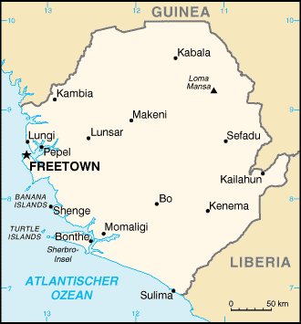
The list of places in Sierra Leone provides an overview of the development of the population of the larger localities of the West African state of Sierra Leone .
By far the largest agglomeration in Sierra Leone is the capital Freetown with a population of 1,050,301 (2015 census). This means that around 15 percent of the country's population is concentrated in the capital region .
The following table contains the cities with more than 8000 inhabitants, the results of the censuses of December 8, 1974, December 15, 1985 and December 4, 2004 as well as December 5, 2015. The higher-level administrative unit ( province and area ) is also listed , to which the city belongs. The population figures refer to the actual city without the suburbs.
| rank | Surname | 1974 | 1985 | 2004 | 2015 | status | function | Province / Territory |
|---|---|---|---|---|---|---|---|---|
| 1. | Freetown | 276.247 | 469.776 | 772.873 | 1,055,964 | city | Capital provincial capital district capital |
Western film |
| 2. | Waterloo | 4,276 | 9,878 | 34,079 | 208,795 | Western film | ||
| 3. | Kenema | 31,458 | 52,473 | 128,402 | 200,443 | city | Provincial capital District capital |
Eastern |
| 4th | Bo | 39,371 | 59,768 | 149,957 | 174,369 | city | Provincial capital District capital |
Southern |
| 5. | Port Loko | 10,500 | 15,248 | 21,961 | 160.217 | city | Provincial capital District capital |
North West |
| 6th | Koidu | 75,846 | 82,474 | 80,025 | 128,303 | city | District capital | Eastern |
| 7th | Makeni | 26,781 | 40,038 | 82,840 | 125.907 | city | Provincial capital District capital |
Northern |
| 8th. | Pandebu | 3,309 | 10,944 | 20,219 | Eastern | |||
| 9. | Goderich | 3,836 | 6,886 | 19.209 | Western film | |||
| 10. | Lunsar | 16,723 | 16,073 | 16,567 | North West | |||
| 11. | Magburaka | 10,347 | 11.006 | 16,313 | District capital | Northern | ||
| 12. | Mile 91 | ... | 7.210 | 15,491 | Northern | |||
| 13. | Kabala | 7,847 | 13,923 | 14,108 | District capital | Northern | ||
| 14th | Kailahun | 7.184 | 9,054 | 13,108 | 153.286 | District capital | Eastern | |
| 15th | Cambia | 5,740 | 7,631 | 11,842 | District capital | Northern | ||
| 16. | Bonthe | 6,398 | 7.210 | 9,740 | 9,975 | city | District capital | Southern |
| 17th | Rokupr | 5,780 | 8,283 | 9.285 | Northern | |||
| 18th | Blama | 4,743 | 5,559 | 8,603 | Eastern | |||
| 19th | Segbwema | 6,915 | 8,257 | 7,961 | Eastern | |||
| 20th | Mattru | 3,891 | 5,804 | 7,647 | Southern | |||
| 21st | Pujehun | 2,802 | 3.85 | 7,571 | District capital | Southern | ||
| 22nd | Pendembu | 4,270 | 5,644 | 7,243 | Eastern | |||
| 23. | Yengema | 14,793 | 12,938 | 3,621 | Eastern | |||
| 24. | Koindu | 4,956 | 8,238 | ... | Eastern | |||
| 25th | Bump | 4,707 | 7,556 | ... | Southern | |||
| 26th | Kamakwie | 4,837 | 6.287 | ... | District capital | North West | ||
| 27. | Panguma | 4,559 | 5,435 | ... | Eastern | |||
| 28. | Biama | 4,743 | 5,559 | 8,603 | Eastern |
See also
Web links
Individual evidence
- ↑ FINAL RESULTS 2004 POPULATION AND HOUSING CENSUS. Statistics Sierra Leone, February 23, 2006 ( Memento of the original from July 30, 2013 in the Internet Archive ) Info: The archive link has been inserted automatically and has not yet been checked. Please check the original and archive link according to the instructions and then remove this notice. accessed on February 23, 2014
- ↑ 2015 Population and Housing Census SUMMARY OF FINAL RESULTS. Statistics Sierra Leone, December 2016.
- ^ Local Government Amendment Act, 2017. Government of Sierra Leone, June 22, 2017.
