
Manzhou (Pingtung)
|
Manzhou 滿州 鄉 |
|||
.svg) Location Manzhous in Pingtung County |
|||
| State : |
|
||
| County : | Pinging | ||
| Coordinates : | 22 ° 3 ' N , 120 ° 51' E | ||
| Area : | 1422013 km² | ||
| Residents : | 8,067 (Sep. 2018) | ||
| Population density : | 57 inhabitants per km² | ||
| Time zone : | UTC + 8 (Chungyuan time) | ||
| Telephone code : | (+886) (0) 8 | ||
| Postal code : | 947 | ||
| ISO 3166-2 : | TW-PIF | ||
| Community type : | Rural community ( 鄉 , Xiāng ) | ||
| Structure : | 8 villages ( 村 , Cūn ) | ||
| Mayor : | Yu Zhengchun ( 余增春 ) | ||
| Website : | |||
|
|||

Manzhou ( Chinese 滿州鄉 , Pinyin Mǎnzhōu Xiang , Paiwan : Manutsuru ) is a rural municipality in Pingtung County on Taiwan ( Republic of China ).
location
Manzhou is located near the southern tip on the east coast of the island of Taiwan. The municipality consists of hilly mountainous country, which forms the foothills of the Taiwanese central mountains . The terrain is mostly forested or covered by dense tropical vegetation, but occasionally interrupted by meadows. The climate is tropical hot and oceanic influenced. In autumn and winter, the northeast monsoons bring the most rainfall.
The neighboring communities are Mudan in the north, Checheng in the northwest and Hengchun in the south and southwest. The eastern boundary is the Pacific coast ( Philippine Sea ).
History and origin of the name
The original inhabitants were members of the indigenous peoples of Taiwan, more recently the Paiwan . The place name Manzhou is said to have come about through a series of homophonic transformations. In the past, the Paiwan who hunted in the area are said to have left the remains of the hunted animals here, where they would rot. This is how the original Paiwan name vangecul came about, which means something like "stinky". The Han Chinese settlers who came to the area in large numbers from the 19th century took up the phonetic name and transformed it into the Minnan- Chinese 蚊 蟀 , báng sut meaning “mosquito” or “mosquito”. At the time of the Japanese colonial rule in Taiwan in 1920 another homophonic renaming took place in 満 州 庄 , Mǎnzhōu Zhuāng , in the Japanese version Manshū Shō , " Manchurian village". After Taiwan became part of the Republic of China in 1945 , Manzhou became a rural community ( 鄉 , Xiāng ) in the newly established Pingtung County in 1950, using the new spelling 滿州 .
population
According to official statistics, 2144 people (around 27%) belonged to the indigenous peoples at the end of 2017. Most of the time it was Paiwan . The majority of the population are Han Chinese ( Hoklo and Hakka ).
| Outline of Manzhou |
|
Gangzi
港 仔 村 Jiupeng
九 棚 村 Zhangle
長樂 村 Xianglin
響 林村 Lide
里德 村 Gangkou
港口 村 Yongjing
永靖 村 a
a: Manzhou
滿州 村 |

Administrative division
Shizi is divided into 8 villages ( 村 , Cūn ): Gangzi ( 港 仔 村 ), Jiupeng ( 九 棚 村 ), Zhangle ( 長樂 村 ), Xianglin ( 響 林村 ), Lide ( 里德 村 ), Gangkou ( 港口 村 ), Yongjing ( 永靖 村 ) and Manzhou ( 滿州 村 ).
traffic
The main traffic artery is the county road 200, which emerges from the provincial road 26 coming from the north and curves west to the south. Further south it turns west and moves into the neighboring community of Hengchun. In the southern section, the county road 200A (200 甲 ) branches off, which leads in a south-easterly direction to the coast, where it leads south of the river Gankou again as provincial road 26 to the island's southern tip.
Agricultural products
Typical agricultural products are "black beans" ( 黑豆 , Hēidòu , probably a form of soybeans), gankou tea and dragon fruit . Hay is also obtained for livestock farming.
Attractions
About a third of the community area (69.5610 km²) is part of Kenting National Park , which is Taiwan's most visited national park . Otherwise the community is not very well developed for tourism. The tropical vegetation, hiking trails, such as the Nanrenhu hiking trail ( 南 仁 湖 步道 ) to the lake of the same name ( 南 仁 湖 , Nánrén hú ), the dune landscape of Jiupeng ( 九 棚 沙漠 , "Jiupeng desert", ![]() ), the Jialeshui are worth seeing -Waterfalls ( 佳樂 水 瀑布 ,
), the Jialeshui are worth seeing -Waterfalls ( 佳樂 水 瀑布 , ![]() ) and the pedestrian suspension bridge over the Gankou River (
) and the pedestrian suspension bridge over the Gankou River ( ![]() ), etc.
), etc.

Pedestrian suspension bridge over the Gankou River

Gangzai dunes
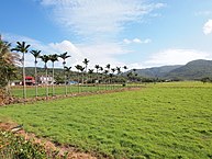
Landscape in Manzhou


Web links
Individual evidence
- ↑ 地理 環境 ("Geographic Area"). Manzhou website, accessed August 18, 2018 .
- ↑ a b 關於 滿州 ("About Manzhou"). Manzhou Township website, accessed August 16, 2018 (Chinese).
- ↑ 原住民 戶數 及 人數 Households and Persons of Indigenous People. (xls) Taiwan Ministry of the Interior, accessed August 4, 2018 (Chinese, English).
- ↑ 農 特 產品 ("Agricultural Products"). Manzhou website, accessed August 16, 2018 (Chinese).
- ↑ 各 國家 公園 基本 資料 表 (“Basic information table about the national parks”). (No longer available online.) October 12, 2010, formerly in the original ; Retrieved October 26, 2018 (Chinese). ( Page no longer available , search in web archives ) Info: The link was automatically marked as defective. Please check the link according to the instructions and then remove this notice.
- ↑ Jioupeng Desert. Taiwan Tourism Authority, accessed August 18, 2018 .
- ↑ Gangkou suspension bridge. Dapeng National Landscape Area, accessed August 18, 2018 .