Metzerlen-Mariastein
| Metzerlen-Mariastein | |
|---|---|
| State : |
|
| Canton : |
|
| District : | Dorneck |
| BFS no. : | 2477 |
| Postal code : | 4116 |
| Coordinates : | 602115 / 257 322 |
| Height : | 526 m above sea level M. |
| Height range : | 446–875 m above sea level M. |
| Area : | 8.48 km² |
| Residents: | 933 (December 31, 2018) |
| Population density : | 110 inhabitants per km² |
| Website: | www.metzerlen.ch |
|
Road to Metzerlen |
|
| Location of the municipality | |
Metzerlen-Mariastein (dialect: Mätzerle, im Stäi ) is a municipality in the district of Dorneck in the canton of Solothurn in Switzerland . The current name of the municipality was only made the official name in 2003, previously the municipality was called Metzerlen . The district of Mariastein is an important place of pilgrimage.
geography
Metzerlen-Mariastein lies at 526 m above sea level. M. , 14 km southwest of the city of Basel (linear distance). The clustered village of Metzerlen extends on a slope slightly to the north at the northern foot of the Blauenkette , above the Metzerlen high plateau, in the Solothurn enclave of the rear Leimental , near the border with France .
The area of the 8.5 km² municipal area covers a section of the northern Jura . The northern border runs on the forest-covered ridge of the Usserholz ( 581 m above sea level ), one of the Jura folds in front of the blue chain. From here the parish grounds extend southward over the longitudinal hollow of Metzerlen-Mariastein, which is more than 1 km wide. It forms a syncline which has been filled with erosion material and covered with loess since the Tertiary . The eastern boundary of the municipality lies on the edge of the rock in front of the steep drop to the gorge of a source brook of the Binnbach .
The anticline of the Blue Chain connects to the south of the Metzerlen plateau . Its northern slope in the Metzerlen area is subdivided into the hard limestone layer of the Chöpfli ( 701 m above sea level ) and the Gobenrain and the softer, more eroded clay and marl layers of the Bättetal . The southern municipal boundary runs along the ridge of the Blauenkette; at 875 m above sea level M. the highest point of Metzerlen-Mariastein is reached on the Challplatten . The western boundary forms the valley of a source stream of the Birsig , which begins at the road pass of the Challhöchi . In 2014, 8% of the municipal area was accounted for by settlements, 46% for forests and woodlands and 46% for agriculture.
Metzerlen-Mariastein consists of the districts of Metzerlen ( 526 m above sea level ) and Mariastein ( 512 m above sea level ), on the plateau west of the gorge in the catchment area of the Binnbach, and a few individual farms. Neighboring communities of Metzerlen-Mariastein are Hofstetten-Flüh and Rodersdorf in the canton of Solothurn, Blauen , Dittingen , Röschenz and Burg im Leimental in the canton of Basel-Landschaft and Biederthal and Leymen in neighboring France.
population
With 933 inhabitants (as of December 31, 2018), Metzerlen-Mariastein is one of the smaller communities in the canton of Solothurn. 194 of them live in the Mariastein district. 96.6% of the residents speak German, 0.7% speak English and 0.6% speak French (as of 2000). The population of Metzerlen-Mariastein was 482 in 1850 and 522 in 1900. In the course of the 20th century the population increased slowly but continuously (720 inhabitants were counted in 1980).
economy
Metzerlen-Mariastein was a predominantly agricultural village until the second half of the 20th century . Even today arable farming , fruit growing (mainly cherry trees) as well as cattle breeding and dairy farming have an important place in the employment structure of the population, although the number of farms has declined sharply since 1950. Further jobs are available in local small businesses and in the service sector. Today Metzerlen-Mariastein is home to construction, electrical and information technology companies. In the last few decades the village has developed into a residential community. Most of the employed are therefore commuters who mainly work in the Basel region. The Mariastein monastery is next to the Einsiedeln monastery the second most important place of pilgrimage in Switzerland, which is why the district of Mariastein is geared towards pilgrimage and pilgrimage tourism.
traffic
The community is located off the main thoroughfares on a connecting road from Oberwil (BL) over the Challhöchi to Laufen . The village is connected to the public transport network through a Postbus course , which runs the route from Flüh train station to Metzerlen. At certain times of the day a post bus runs from Mariastein to Laufen.
history
The municipality of Metzerlen-Mariastein was already settled during the Iron Age, which has been proven by several finds. The first written mention of the place took place in 1194 under the name Mezherlon . Later the names Metzerlon (1213), Meiszerlo (1278), Mezerlon (1280) and Metzerlenn (1290) appeared. The place name goes back to the Latin word maceriolum ( little wall).
Metzerlen was part of the Rotberg rule since the Middle Ages . For a long time this rule had the status of a free imperial fiefdom , which was directly subordinate to the emperor, which is why Metzerlen was considered one of the seven free imperial villages on the Blue. The Rotberg rule came to Solothurn by purchase in 1515 and was subsequently assigned to the Dorneck bailiwick and the Leimental district court. After long negotiations, Solothurn allowed the Benedictine monastery to be relocated from the isolated Beinwil to Mariastein. In 1645 the foundation stone for the construction of the new monastery was laid. After the collapse of the Ancien Régime (1798), Metzerlen belonged to the Dornach district during the Helvetic Republic and from 1803 to the Dorneck district.
Great poverty among craftsmen and day laborers led to a wave of emigration in the 19th century. In the course of the Kulturkampf , the Mariastein monastery was abolished by referendum in 1874, and the monks moved to Delle in France. With another referendum in 1970, the monastery was officially restored. When the community of residents and the community of Metzerlen merged to form a unified community on January 1, 2003, the community name Metzerlen was changed to Metzerlen-Mariastein, which means that the well-known district of Mariastein was also entered in the community registers.
Attractions
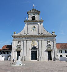
The Church of St. Remigius in Metzerlen was rebuilt in 1821. The original church probably goes back to the Franconian times. In the district of Mariastein there is the Benedictine monastery , built from 1645, with a spacious monastery church in the post-Gothic style, which has a baroque interior. The St. Anna Chapel, which was built in 1691, stands on the northeastern municipal boundary. Rotberg Castle originally dates from the 12th century . The castle, which fell into ruin, was rebuilt between 1934 and 1936 and is now a youth hostel.
coat of arms
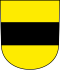
- In yellow black crossbar. The coat of arms is based on that of the Lords of Rotberg
literature
- Gottlieb Loertscher: The art monuments of the canton of Solothurn, Volume III: The districts of Thal, Thierstein, Dorneck. (= Art Monuments of Switzerland. Volume 38). Edited by the Society for Swiss Art History GSK. Bern 1957, DNB 750089342 .
Web links
- Official website of the municipality of Metzerlen-Mariastein
- Lukas Schenker: Beinwil-Mariastein. In: Historical Lexicon of Switzerland .
- Lukas Schenker: Metzerlen-Mariastein. In: Historical Lexicon of Switzerland .
Individual evidence
- ↑ Permanent and non-permanent resident population by year, canton, district, municipality, population type and gender (permanent resident population). In: bfs. admin.ch . Federal Statistical Office (FSO), August 31, 2019, accessed on December 22, 2019 .


