Mirebel
| Mirebel | ||
|---|---|---|
|
|
||
| local community | Skin week | |
| region | Bourgogne-Franche-Comté | |
| Department | law | |
| Arrondissement | Lons-le-Saunier | |
| Coordinates | 46 ° 42 ' N , 5 ° 44' E | |
| Post Code | 39570 | |
| Former INSEE code | 39332 | |
| Incorporation | January 1, 2016 | |
| status | Commune déléguée | |
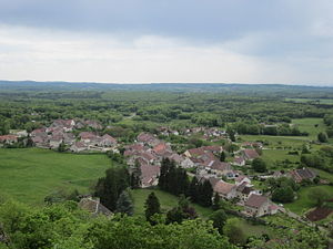
 View of Mirebel |
||
Mirebel is a town and commune Déléguée in the French community Haute Roche with 231 inhabitants (at January 1, 2017) in the department of Jura in the region Bourgogne Franche-Comté .
geography
Mirebel is located at 575 m , about 14 kilometers east of the city of Lons-le-Saunier (as the crow flies). The village extends in the Jura , in the central part of the Plateau Lédonia (first Jura plateau), at the western foot of the heights of the Côte de l'Heute.
The area of the 16.63 km² former municipal area covers a section of the French Jura. The western part of the area is taken up by the plain of the Plateau Lédonia, which lies at an average of 560 m and consists partly of arable and meadow land, partly of forest ( Bois du Chanay and Bois des Chaumois ). The plateau has no above-ground watercourses because the rainwater seeps into the karstified subsoil. In the east the plateau is bounded by the wooded ridge of the Côte de l'Heute , which is divided into several elongated ridges and on which the highest elevation of Mirebel is reached at 750 m .
Neighboring towns to Mirebel are La Marre , Bonnefontaine and Pont-du-Navoy in the north, Montigny-sur-l'Ain in the east, Châtillon and Verges in the south and Vevy , Crançot , Baume-les-Messieurs and Granges-sur-Baume in the west .
history
Various finds indicate that the Mirebel area was already inhabited in Gallo-Roman times. Mirebel is mentioned in a document in the 12th century. The place name originally comes from the Latin word mirari (look, admire) and the old French bel (beautiful). The castle of Mirebel, built in the Middle Ages, belonged to the Counts of Vienne, who resided here for a long time. A settlement developed at the foot of the castle hill, which was granted freedom rights in 1292. In the 15th century, the castle passed to the Chalon-Arlay family. In 1479 the castle and castle town were occupied by the troops of King Louis XI. destroyed. Together with Franche-Comté , Mirebel came to France with the Peace of Nijmegen in 1678.
With effect from January 1, 2016, Mirebel was merged with the former municipalities of Granges-sur-Baume and Crançot to form Commune nouvelle Hauteroche. The municipality of Mirebel belonged to the arrondissement of Lons-le-Saunier and the canton of Poligny .
Attractions
The parish church of Saint-André was built in the 13th century in Gothic styles and redesigned in the 17th century. On the castle hill are the ruins of the medieval castle, built in the 12th century, and nearby on a rocky promontory is the statue of Notre-Dame du Guet, from which you can enjoy a beautiful view of the surroundings. At the foot of the mountain there is a mansion that dates back to the Renaissance period and was modernized in the 18th century.
population
| Population development | |
|---|---|
| year | Residents |
| 1962 | 281 |
| 1968 | 224 |
| 1975 | 197 |
| 1982 | 193 |
| 1990 | 185 |
| 1999 | 202 |
After the population had decreased markedly in the first half of the 20th century (in 1896 there were still 522 people), there has been a slight increase in population since the beginning of the 1990s.
Economy and Infrastructure
Until well into the 20th century, Mirebel was primarily a village characterized by agriculture and forestry. In addition, there are now some local small businesses. In the meantime, the village has also turned into a residential community. Many workers are commuters who work in the larger towns in the area.
The village is very well developed in terms of traffic. It is on the main road D471, which leads from Lons-le-Saunier to Champagnole . There are other road connections with Châtillon, Bonnefontaine and La Marre.
