Châtillon (Jura)
| Châtillon | ||
|---|---|---|
|
|
||
| region | Bourgogne-Franche-Comté | |
| Department | law | |
| Arrondissement | Lons-le-Saunier | |
| Canton | Poligny | |
| Community association | Pays des Lacs | |
| Coordinates | 46 ° 40 ′ N , 5 ° 44 ′ E | |
| height | 447-747 m | |
| surface | 16.77 km 2 | |
| Residents | 112 (January 1, 2017) | |
| Population density | 7 inhabitants / km 2 | |
| Post Code | 39130 | |
| INSEE code | 39122 | |
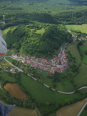
 View of Châtillon |
||
Châtillon , unofficially Châtillon-sur-Ain called, is a commune in the French department of Jura in the region Bourgogne Franche-Comté .
geography
Châtillon is located at 520 m , about 14 kilometers east of the city of Lons-le-Saunier (as the crow flies). The village extends in the Jura , in the valley of the Combe d'Ain, on a slightly elevated position on the western edge of the wide Ain valley at the foot of the castle hill and the Côte de l'Heute, west of the Lac de Chalain .
The area of the 16.77 km² municipal area covers a section of the French Jura. The eastern part of the area is occupied by the wide plain of the Combe d'Ain, which averages 480 m . The river itself, which in parts forms the eastern border, is sunk into this plain with a 50 m deep valley and only emerges south of the village into a wide valley low. It is dammed up below the confluence of the Hérisson to generate electricity to form an elongated lake.
From the course of the river, the municipality extends westward over the plateau to the forest-covered, elongated ridge of the Côte de l'Heute , on which the highest elevation of Châtillon is reached at 750 m . In front of this ridge is the castle hill of Châtillon ( 608 m ). In the far west, the area extends into the extensive Bois des Chaumois forest and the Côte de Thorne ( 613 m ).
Neighboring municipalities of Châtillon are Hauteroche and Montigny-sur-l'Ain in the north, Marigny and Doucier in the east, Charcier , Charézier and Blye in the south and Verges in the west.
history
The place name goes back to the Latin word castellum (small castle). A fortress was built on the hill of Châtillon as early as the 9th century, around which the settlement of Bourg-Dessus developed over time. Castle and settlement were destroyed and abandoned in the 17th century. The present-day village of Châtillon goes back to the settlement of Bourg-Dessous, which was founded in the 14th century at the foot of the castle hill and was granted certain freedoms in 1341. Since the 11th century, Curtine has been another village in what is now the municipality, but it was destroyed in the 14th century and never rebuilt. Together with Franche-Comté , Châtillon came to France with the Peace of Nijmegen in 1678.
Attractions
The current village church of Saint-Valère was built in 1806 on the site of the medieval Chapelle de l'Aigle, which had existed since 1414. In the municipality there is also the Saint-Valère chapel and another 17th century chapel. Only a few remains of the former castle (building from the 12th century) have been preserved.
population
| Population development | |
|---|---|
| year | Residents |
| 1962 | 240 |
| 1968 | 209 |
| 1975 | 174 |
| 1982 | 133 |
| 1990 | 128 |
| 1999 | 127 |
| 2006 | 124 |
With 112 inhabitants (as of January 1, 2017), Châtillon is one of the smallest communes in the Jura department. After the population had decreased markedly in the first half of the 20th century (444 people were still counted in 1891), only minor fluctuations have been recorded since the beginning of the 1980s.
Economy and Infrastructure
Until well into the 20th century, Châtillon was a village dominated by agriculture and forestry. In addition, there are now some local small businesses. In the meantime, the village has also turned into a residential community. Many workers are commuters who work in the larger towns in the area.
The village is located off the major thoroughfares on a departmental road that leads from Lons-le-Saunier to Doucier. Other regional road connections exist with Pont-de-Poitte and Pont-du-Navoy .


