Le Pin (Jura)
| Le pin | ||
|---|---|---|

|
|
|
| region | Bourgogne-Franche-Comté | |
| Department | law | |
| Arrondissement | Lons-le-Saunier | |
| Canton | Poligny | |
| Community association | Espace Communautaire Lons Agglomération | |
| Coordinates | 46 ° 43 ' N , 5 ° 34' E | |
| height | 270-385 m | |
| surface | 2.82 km 2 | |
| Residents | 241 (January 1, 2017) | |
| Population density | 85 inhabitants / km 2 | |
| Post Code | 39210 | |
| INSEE code | 39421 | |
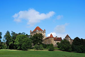
 Castle in Le Pin from the 13th century |
||
Le Pin is a commune in the Jura department in the region of Bourgogne Franche-Comté . It belongs to the arrondissement of Lons-le-Saunier and the canton of Poligny . It borders on Montain in the north, Lavigny in the northeast, Pannessières in the southeast, Chille in the south, Villeneuve-sous-Pymont in the southwest and Plainoiseau and L'Étoile in the west .
Population development
| 1962 | 1968 | 1975 | 1982 | 1990 | 1999 | 2008 | 2013 |
|---|---|---|---|---|---|---|---|
| 109 | 89 | 120 | 179 | 256 | 256 | 264 | 256 |
economy
Le Pin is part of the Côtes du Jura wine-growing region .
Web links
Commons : Le Pin - collection of images, videos and audio files
