Monte Cerignone
| Monte Cerignone | ||
|---|---|---|

|
|
|
| Country | Italy | |
| region | Brands | |
| province | Pesaro and Urbino (PU) | |
| Coordinates | 43 ° 50 ' N , 12 ° 25' E | |
| height | 528 m slm | |
| surface | 18.04 km² | |
| Residents | 653 (Dec. 31, 2019) | |
| Population density | 36 inhabitants / km² | |
| Post Code | 61010 | |
| prefix | 0541 | |
| ISTAT number | 041031 | |
| Popular name | Cerignonesi | |
| Patron saint | Blaise of Sebaste | |
| Website | Monte Cerignone | |

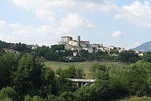
View of Monte Cerignone, with the Malatesta Castle in the center (built in the late 15th century)
Monte Cerignone (in the local dialect: Mun'Cirignón ) is an Italian community ( comune ) in the Marche region (Italian: Marche ) in the province of Pesaro and Urbino and has 653 inhabitants (as of December 31, 2019). The municipality is located about 40 kilometers west-southwest of Pesaro and about 24 kilometers northwest of Urbino and belongs to the Comunità montana del Montefeltro .
Parish partnership
Monte Cerignone maintains an intra-Italian partnership with the municipality of Randazzo in the metropolitan city of Catania .
Web links
Commons : Monte Cerignone - collection of images, videos and audio files
Individual evidence
- ↑ Statistiche demografiche ISTAT. Monthly population statistics of the Istituto Nazionale di Statistica , as of December 31 of 2019.
