Novosybkov
| city
Novosybkov
Novozybkov
|
||||||||||||||||||||||||||||||||||||||||
|
||||||||||||||||||||||||||||||||||||||||
|
||||||||||||||||||||||||||||||||||||||||
| List of cities in Russia | ||||||||||||||||||||||||||||||||||||||||
Novosybkow ( Russian Новозыбков ) is a city in the Bryansk Oblast ( Russia ) with 40,553 inhabitants (as of October 14, 2010).
geography
The city is located in the Dnepr lowlands about 200 kilometers southwest of the Oblast capital, Bryansk, on the Korna river, not far from its confluence with the Iput in the Dnepr river system .
Novosybkow forms a rajon travel district and is also the administrative center of the raion of the same name .
To the southeast is Klimowo .
history
In 1701 a Sloboda (handicraft and trading village) Sybkaja was mentioned in a document, which was founded around 1686 by the old Orthodox . Later the name Sypkow was also used.
After moving to a less flood-prone area, Novo- (Russian for new ) was placed in front of the place name. On February 11, 1809 the town charter was granted. After the first factory was built in 1864, the city developed into one of the most important centers for matchmaking in Russia with over ten plants by the beginning of the 20th century . In the turmoil after the October Revolution of 1917, this branch of industry came to a complete standstill.
During the Second World War Novosybkow was occupied by the German Wehrmacht on August 16, 1941 and recaptured on September 25, 1943 by troops of the Bryansk Front and the Central Front of the Red Army while advancing from Bryansk towards Chernihiv and Pripyat .
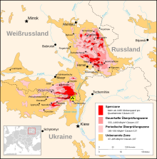
As a result of the Chernobyl disaster in 1986, Novosybkow and the surrounding Rajon are among the most radioactively contaminated areas in Russia: an uninhabitable exclusion zone begins immediately to the west of the city, contaminated with over 1.5 MBq per square meter.
Population development
| year | Residents |
|---|---|
| 1897 | 15,362 |
| 1926 | 19,900 |
| 1939 | 24,485 |
| 1959 | 25,852 |
| 1970 | 34,433 |
| 1979 | 41,226 |
| 1989 | 44,854 |
| 2002 | 43,038 |
| 2010 | 40,553 |
Note: census data (1926 rounded)
economy
In Novosybkow there are mechanical and electrical engineering, textile and food industries.
The city lies on the railway line Bryansk - Homel - Brest opened in 1887 by the Polessje Railways (route kilometers 208), from which a line to Novhorod-Siverskyj ( Ukraine ) branches off here. The M13 trunk road also leads from Brjansk to the Belarusian border south of Novosybkow.
sons and daughters of the town
- Pawel Jefimowitsch Dybenko (1889–1938), revolutionary and naval officer
- Alexander Schapiro (1890–1942), Ukrainian anarchist of Jewish descent
- Grigori Roshal (1899–1983), director and screenwriter
- Rostislaw Alexejew (1916–1980), Soviet ship and aircraft designer
- Samson Samsonow (1921–2002), director, screenwriter and actor
Individual evidence
- ↑ a b Itogi Vserossijskoj perepisi naselenija 2010 goda. Tom 1. Čislennostʹ i razmeščenie naselenija (Results of the All-Russian Census 2010. Volume 1. Number and distribution of the population). Tables 5 , pp. 12-209; 11 , pp. 312–979 (download from the website of the Federal Service for State Statistics of the Russian Federation)
Web links
- Unofficial city website (Russian)
- Novosybkow on mojgorod.ru (Russian)


