
Nyanza (Kenya)
| Nyanza | |
|---|---|
  |
|
| Basic data | |
| Capital | Kisumu |
| surface | 12,507 km² |
| Residents | 5,050,000 (calculation 2007) |
| Population density | 404 inhabitants per km² |
| ISO 3166-2 | KE-600 (repealed) |
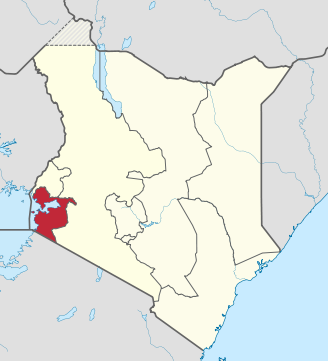
Nyanza was a province of Kenya . Their capital was Kisumu . The province bordered Tanzania , Uganda and Lake Victoria . The lake gave its name: Nyanza means "large body of water" or "lake" in the language of the Sukuma who live in neighboring Tanzania .
The province had about 5,050,000 inhabitants. The most important population group in Nyanza were the Nilotic Luo , in addition to which Bantu ethnicities such as the Kisii (Gusii), Kuria and Luhya lived here .
The area of the former Nyanza has a humid tropical climate.
As part of the 2010 constitution , the Kenyan provinces were dissolved. The counties Homa Bay , Kisii , Kisumu , Migori , Nyamira and Siaya are located in the territory of the Nyanza Province today .
Administrative division
Nyanza was divided into 12 districts:
| District | Capital |
|---|---|
| Bondo | Bondo |
| Gucha / Ogembo / South Kisii | Ogembo |
| Homa Bay | Homa Bay |
| Kisii Central | Kisii |
| Kisumu | Kisumu |
| Kuria | Kehancha |
| Migori | Migori |
| Nyamira / Kisii North | Nyamira |
| Nyando | Awasi |
| Rachuonyo | Oyugis |
| Siaya | Siaya |
| Suba | Mbita Point |
swell
- ↑ bevölkerungsstatistik.de (2007)
Central | Coast | Eastern | Nairobi | North-Eastern | Nyanza | Rift Valley | Western film
Coordinates: 0 ° 30 ′ 0 ″ S , 34 ° 30 ′ 0 ″ E