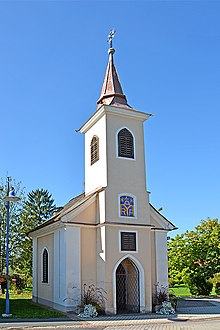
Obervogau
|
Obervogau (former municipality) locality Cadastral municipality Obervogau |
||
|---|---|---|
|
|
||
| Basic data | ||
| Pole. District , state | Leibnitz (LB), Styria | |
| Judicial district | Leibnitz | |
| Coordinates | 46 ° 44 ′ 50 " N , 15 ° 35 ′ 0" E | |
| height | 260 m above sea level A. | |
| Residents of the village | 893 (January 1, 2020) | |
| Building status | 245 (2001 ) | |
| Area d. KG | 3.96 km² | |
| Postcodes | 8461, 8472 | |
| prefix | + 43/3453 | |
| Statistical identification | ||
| Community code | 61058 | |
| Locality code | 15526 | |
| Cadastral parish number | 66157 | |
| Counting district / district | Obervogau (61058 002) | |
 Location of the former municipality in the Leibnitz district |
||
| Independent municipality until the end of 2014 Source: STAT : Local directory ; BEV : GEONAM ; GIS-Stmk |
||
Obervogau is a village and former municipality with 893 inhabitants (as of January 1, 2020) in the Leibnitz district in the Austrian state of Styria . As part of the municipal structural reform in Styria , it has merged with the municipalities of Straß in der Steiermark , Spielfeld and Vogau since January 1, 2015 , the new municipality was renamed Straß-Spielfeld in 2015 , and since 2016 the name of the former municipality of Straß in Styria .
The basis for this is the Styrian Municipal Structural Reform Act - StGsrG.
geography
Obervogau is located on a mire arch in southern Styria.
The only cadastral community and village is Obervogau.
Together with the municipalities of Arnfels , Berghausen , Ehrenhausen, Eichberg-Trautenburg , Gamlitz , Glanz , Gleinstätten , Großklein , Heimschuh , Kaindorf an der Sulm , Kitzeck im Sausal , Leutschach , Oberhaag , Pistorf , Ratsch an der Weinstrasse , Retznei, Sankt Andrä-Höch , St. Johann im Saggautal , Sankt Nikolai im Sausal , Schloßberg , Seggauberg , Spielfeld , Straß in Steiermark , Sulztal an der Weinstrasse and Vogau Obervogau was a member of the Südsteirisches Weinland nature reserve.
Neighboring communities by the end of 2014
| Gabersdorf | Sankt Veit am Vogau | |
| Wagna |

|
|
| Retznei | Vogau |
history
1271 is mentioned for the first time in a document as Superis Vogan . The local community as an autonomous body was established in 1850. After the annexation of Austria in 1938, the community came to the Reichsgau Steiermark, 1945 to 1955 it was part of the British zone of occupation in Austria.
politics
The last mayor was Johann Rauscher until December 31, 2014. After the municipal council elections from 2010 to December 31, 2014, the municipal council was composed as follows: 6 ÖVP , 3 SPÖ .
coat of arms
The coat of arms awarded in 1975 shows:
- "In the silver shield a blue arch bridge, topped with a golden post horn."
Culture and sights
Buildings
- Reservoir and Obervogau power plant
Individual evidence
- ↑ Statistics Austria: Population on January 1st, 2020 by locality (area status on January 1st, 2020) , ( CSV )
- ^ Styrian municipal structural reform .
- ↑ Section 3, Paragraph 5, Item 2 of the Act of December 17, 2013 on the reorganization of the municipalities of the State of Styria ( Styrian Municipal Reform Act - StGsrG). Provincial Law Gazette for Styria of April 2, 2014. No. 31, year 2014. ZDB -ID 705127-x . P. 3.
- ↑ http://www.naturparkweinland.at


