
Ratsch on the Wine Route
|
Ratsch an der Weinstrasse ( village ) locality cadastral community Ratsch |
|||
|---|---|---|---|
|
|||
| Basic data | |||
| Pole. District , state | Leibnitz (LB), Styria | ||
| Judicial district | Leibnitz | ||
| Pole. local community | Ehrenhausen on the Weinstrasse | ||
| District | Ratchet | ||
| Coordinates | 46 ° 41 '20 " N , 15 ° 34' 13" E | ||
| height | 352 m above sea level A. | ||
| Residents of the village | 331 (January 1, 2020) | ||
| Building status | 190 (2011 ) | ||
| Area d. KG | 5.49 km² | ||
| Post Code | 8461 Ehrenhausen | ||
| Statistical identification | |||
| Locality code | 15541 | ||
| Cadastral parish number | 66160 | ||
| District | Ratchet | ||
| Counting district / district | Ratsch an der Weinstrasse (61049 003) | ||
 The village of Ratsch and the surrounding area |
|||
| Source: STAT : index of places ; BEV : GEONAM ; GIS-Stmk | |||

Ratsch an der Weinstrasse ( Slovene Račane ) is a place in the Windischen Büheln in Styria as well as a district (Ratsch) , locality and cadastral community (Ratsch) of the community Ehrenhausen an der Weinstrasse in the Leibnitz district of southwest Styria .
The former community was attached to Ehrenhausen in 2015 .
geography
Ratsch an der Weinstrasse is located on the border with Slovenia , about 11 kilometers south of Leibnitz , around 5½ km west of the Spielfeld / Šentilj border crossing , 4 km southwest of the municipal capital Ehrenhausen .
The village of Ratsch an der Weinstrasse is 350 m above sea level. A. Height in the valley of the Ratscher Bach , which flows into the Gamlitzbach at Gamlitz , already at the foot of the border mountain Witscheinberg / Svečinski vrh ( 515 m / 517 m ). It has about 60 addresses.
The village of Ratsch an der Weinstrasse or the cadastral municipality of Ratsch comprises almost 150 buildings with around 330 inhabitants with 548.53 hectares . The local area also includes the scattered houses Stermetzberg , the Rotte Schusterberg and the scattered houses Ratschergraben left in the valley out of the valley (northward), the scattered houses Nussberg right in the valley (east), the scattered houses Köbelberg south, and the scattered houses Kroisenbach in the neighboring valleys of the same name west. The Grenzland Wine Road ( L613 ) forms the southern border.
The district of Ratsch of the municipality also includes the locality and cadastral community of Ottenberg (331 inhabitants, as of January 1, 2020), making this area, which represents the former municipality, 826.92 hectares, around 190 buildings and 448 inhabitants (as of 31. October 2013) has.
Neighboring places
|
|
Gamlitz (O, KG and OT, Gem.Gamlitz ) |
|
|
Eckberg (O & KG, Gem.Gamlitz )
|
.svg)
|
Ottenberg (O and KG) Berghausen
(OT) |
|
Sulz (O and KG, Gem. Gamlitz ) |
Köbelberg
Slatina Svečina |
Ratsch ( district ) Former municipality of Ratsch [on the Wine Route] |
|
|---|---|
| Basic data | |
| Pole. District , state | Leibnitz , Styria |
| Pole. local community | Ehrenhausen on the Weinstrasse |
| Coordinates | 46 ° 41 ′ 54 " N , 15 ° 34 ′ 16" E |
| height | 350 m above sea level A. |
| Residents of the stat. An H. | 448 (October 31, 2013) |
| Building status | 174 (2001 ) |
| surface | 8.27 km² |
| Location in the Leibnitz district | |

|
|
| OT includes O / KG / ZSpr Ratsch [ adWeinstr. ] and Ottenberg ; independent municipality 1850–2014 (Gkz. 61028; name Ratsch adWeinstr. from 1961; municipality capital Ratsch ) Source: STAT : place directory ; BEV : GEONAM ; GIS-Stmk ; local community |
|
history
Ratsch was first mentioned in the 11th century under the name Rats .
In the 17th century the place was owned by the Protestant Nikolaus Kempintsy, son of Caspar Kempintsy and Ellse Beuerl, who emigrated to Alsace in 1629 and sold Ratsch to Wolf Freiherr von Eggenberg .
Former parish

The local community as an autonomous body of the Crown Land of Styria (Duchy of Steyer) was established in 1850 after the revolution of 1848/49 . In the then bilingual area, a first German school was opened on November 6, 1882 on the initiative of the Döfler.
After the annexation of Austria in 1938, the community became part of the Reichsgau Steiermark , from 1945 to 1955 it was part of the British zone of occupation in Austria . The first mayor of the post-war period was Johann Deutscher. In 1946 the parish hall was set on fire by partisans.
In 1961 the name was added to the Weinstrasse (LGBl. 41/1961). In 1962, the municipality of Ottenberg , which had also been independent since 1850, was incorporated as a cadastral municipality (LGBl. 106/1961).
Since 2015, Ratsch has been merged with the municipalities of Berghausen , Ehrenhausen and Retznei as part of the Styrian municipal structural reform , the new municipality bears the name Ehrenhausen an der Weinstrasse . In the event of a vote, 80% of the community citizens spoke out in favor of Ehrenhausen and against Gamlitz, so that the amalgamation of the municipalities went smoothly. The former municipality area will be continued as a district (local area) of the new municipality, the addition to the name continues to apply to the village.
The last mayor since 1999 was the winemaker Johannes Zweytick (ÖVP, member of the National Council 1994-2008; since 2015 Vice Mayor of Ehrenhausen). After the 2010 elections, the municipal council was composed as follows: 7 ÖVP , 2 SPÖ .
coat of arms
The coat of arms of the former municipality shows a Klapotetz , a grape and the South Styrian Wine Route .
Economy, infrastructure and culture
Viticulture is practiced in Ratsch .
The Grenzland-Weinstrasse ( L613 ) Ehrenhausen - Leutschach , which is part of the tourist route of the Southern Styrian Wine Route , runs along the southern border .
The Urbani Chapel was completed in 1972 and dedicated to the wine saint Urban .
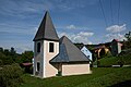
Urbani Chapel

Wayside shrine

Ratscher plane tree (natural monument)


Web links
- Ratchet. Tourism - Leisure - Culture → Special in the districts. In: ehrenhausen-gv.at. Archived from the original on November 2, 2016 .
- 61049 - Ehrenhausen on the Weinstrasse. Community data, Statistics Austria .
Individual evidence
- ↑ Statistics Austria: Register census from October 31, 2011 (pdf).
- ↑ a b c Specials in the districts ( memento of December 10, 2016 in the Internet Archive ) ehrenhausen-gv.at, Tourism - Leisure - Culture (accessed July 27, 2016).
- ↑ Statistics Austria: Population on January 1st, 2020 by locality (area status on January 1st, 2020) , ( CSV )
- ↑ a b c d e f Ratsch ( Memento from November 2, 2016 in the Internet Archive ). Chronicle of the community of Ratsch an der Weinstrasse. ehrenhausen-gv.at (accessed July 28, 2016).
- ^ Ordinance of the Styrian state government of April 19, 1961 on the change of the name of the municipality of Ratsch (political district Leibnitz). LGBl. 41/1961, p. 40 (EReader, ALEX Online ).
- ↑ Ordinance of the Styrian state government of September 25, 1961 on the union of the communities of Ottenberg and Ratsch an der Weinstrasse (political district Leibnitz). LGBl. 106/1961, p. 92 (EReader, ALEX Online).
- ↑ Announcement of the Styrian state government of September 12, 2013 on the unification of the market community Ehrenhausen and the communities Berghausen, Ratsch an der Weinstrasse and Retznei, all political district Leibnitz. Styrian State Law Gazette of October 14, 2013. No. 102, 28th issue. P. 556 (pdf, ris.bka ).
- ↑ A clear yes to Ehrenhausen - the population of Ratsch voted with a large majority for a merger with Ehrenhausen, Berghausen and Retznei. Rejection for Gamlitz. Robert Lenhard in: Kleine Zeitung online, July 29, 2013
- ↑ Notice of public buyers search ehrenhausen-gv.at, community houses (accessed 27 July 2016).
- ↑ Urbani Chapel. In: ehrenhausen.at. Retrieved October 4, 2017 .

All Saints' Day at Wildon |
Arnfels |
Ehrenhausen an der Weinstrasse |
Empersdorf |
Gabersdorf |
Gamlitz |
Gleinstätten |
Gralla |
Large small |
Heiligenkreuz am Waasen |
Heimschuh |
Hengsberg |
Kitzeck im Sausal |
Long |
Lebring-Sankt Margarethen |
Leibnitz |
Leutschach an der Weinstrasse |
Oberhaag |
Ragnitz |
Sankt Andrä-Höch |
Sankt Georgen an der Stiefing |
Sankt Johann im Saggautal |
Sankt Nikolai im Sausal |
Sankt Veit in southern Styria |
Schwarzautal |
Straß in Steiermark |
Tillmitsch |
Wagna |
Wildon
50 former communities (dissolved 1945–1969): Aflenz an der Sulm |
Altenberg near Leibnitz |
Badendorf |
Brünngraben |
Feiting |
Felgitsch |
Flamberg |
Liquid |
Gersdorf an der Mur |
Grötsch |
Hart at Wildon |
Hasendorf an der Mur |
Haslach an der Stiefing |
High |
Hut |
Kainach near Wildon |
Labuttendorf |
Landscha on the Mur |
Lappach |
Lebring |
Guide ring |
Lichendorf ** |
Lind near Sankt Veit am Vogau |
Lipsch |
Maggau * |
Marchtring |
Mitteregg |
Nestelberg |
Neudorf an der Mur |
Neudorf im Sausal |
Neutersdorf |
Oberjahring |
Oberschwarza ** |
Ottenberg |
Perbersdorf near Sankt Veit ** |
Pichla at Mureck ** |
Prarath |
Sankt Margarethen bei Lebring |
Shirka |
Schönberg an der Laßnitz |
Schrötten an der Laßnitz |
Seibersdorf near Sankt Veit ** |
Siebing ** |
Sukdull |
House of Commons |
Unterlabill * |
Unterschwarza ** |
Forest chess |
Weitersfeld an der Mur ** |
Wutschdorf 24 former municipalities (dissolved since 2014): Berghausen |
Breitenfeld am Tannenriegel |
Ehrenhausen |
Eichberg-Trautenburg |
Shine on the Wine Route |
Hainsdorf in the Schwarzautal |
Kaindorf an der Sulm |
Leutschach |
Mitterlabill *** |
Murfeld *** |
Pistorf |
Ratsch on the Wine Route |
Retznei |
Sankt Nikolai ob Draßling |
Sankt Ulrich am Waasen |
Sankt Veit am Vogau |
Schlossberg |
Schwarzau in the Schwarzautal *** |
Seggauberg |
Stocking |
Sulztal on the Wine Route |
Weinburg am Saßbach *** |
Weitendorf |
Wolfsberg in the Schwarzautal municipality was at the time of dissolution in: * Feldbach district ; ** Radkersburg district ; *** District of Southeast Styria

Cadastral communities: Ehrenhausen | Ewitsch | Ottenberg | Ratchet | Retznei | Unterlupitscheni | Wielitsch
Districts (municipality structure) : Berghausen | Ehrenhausen | Ratchet | Retznei
Locations: Ehrenhausen | Ewitsch | Ottenberg | Ratsch on the Wine Route | Retznei | Unterlupitscheni | Wielitsch | Zieregg
Market place: Ehrenhausen | Villages: Ratsch an der Weinstrasse • Retznei | Rotten: Ewitsch • Schusterberg • Zieregg | Scattered houses: Köbelberg • Kroisenbach • Nussberg • Oberranzried • Ottenberg • Ratschergraben • Stermetzberg • Unterlupitscheni • Unterranzried • Wielitsch • Witscheinberg | Other locations: Lafarge Perlmooser AG • Ehrenhausen Castle
Counting district: Ehrenhausen | Berghausen | Ratchet | Ottenberg | Retznei
Former communities: Zieregg 1850–1931 | Ottenberg 1850–1962 | Berghausen 1932–2014 | Ratsch [adWeinstr.] 1850–2014 | Retznei 1850-2014