
Lang (Styria)
|
Long
|
||
|---|---|---|
| coat of arms | Austria map | |
 |
|
|
| Basic data | ||
| Country: | Austria | |
| State : | Styria | |
| Political District : | Leibnitz | |
| License plate : | LB | |
| Surface: | 15.67 km² | |
| Coordinates : | 46 ° 50 ′ N , 15 ° 30 ′ E | |
| Height : | 286 m above sea level A. | |
| Residents : | 1,344 (January 1, 2020) | |
| Postal code : | 8403 | |
| Area code : | 03182 | |
| Community code : | 6 10 20 | |
| NUTS region | AT225 | |
| Address of the municipal administration: |
Long 6 8403 Long |
|
| Website: | ||
| politics | ||
| Mayor : | Joachim Schnabel ( ÖVP ) | |
|
Municipal Council : (2015) (15 members) |
||
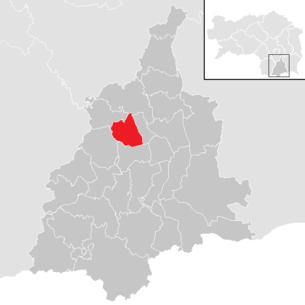
| Location of Lang in the Leibnitz district | ||
  |
||

|
||
| Source: Municipal data from Statistics Austria | ||


Lang ( ) is a municipality in the Leibnitz district in the southern part of the federal state of Styria ( Austria ); it has 1344 inhabitants (as of January 1, 2020).
geography
The community lies on an area of 16 km² at an altitude of 280 to 420 m above sea level. A.
Community structure
On January 1, 1968, the community Schirka was incorporated.
The municipality of Lang consists of six cadastral municipalities (area 2015):
- Göttling (126.33 ha)
- Jöss (309.55 ha)
- Long (136.47 ha)
- Langaberg (56.41 ha)
- Schirka (510.41 ha)
- Stangersdorf (426.91 ha)
Localities are (population in brackets as of January 1, 2020):
- Dexenberg (177)
- Gottling (195)
- Joess (334)
- Jöß industrial area (0)
- Long (184)
- Langaberg (154)
- Shirka (90)
- Stangersdorf (208)
- Stangersdorf industrial park (2)
|
structure
|
||||||
|
Legend for the breakdown table
|
Population development

Neighboring communities
Neighboring municipalities are (alphabetically):
history
Prehistory and early history
For the time being, the oldest known settlement area in the municipality of Lang is the so-called Tischlerhöhe, which was probably originally called Dexenberg. Today the small village of Dexenberg lies at her or his foot. The Tischlerhöhe has all the characteristics of a prehistoric hilltop settlement. The former hilltop was leveled at a point in time that could not be determined without excavations and is sharply sloped on all sides. Stray finds have repeatedly been made on the plateau, which prove the existence of a settlement at this point. It is in the 4th millennium BC. BC and belongs to the area of the Lasinja culture . A few Bronze Age pottery shards could be an indication of a settlement in the 2nd millennium BC. Also in much more recent times, namely in the 9th century BC. At the time of the Urnfield Culture, there seems to have been a settlement in the Dexenberg area. Finds on one of the hillside terraces in Stangersdorf indicate the existence of another Urnfield settlement. Cremation graves from the Hallstatt period from the 7th century BC that were destroyed during the construction of the motorway in Stangersdorf were younger . These graves and another one from the late La Tène period , that is, from the 1st century BC, which also came to light in 1977, are clear indications of nearby settlements at that time. During the road construction work, some prehistoric pits were also cut, which cannot be assessed in detail for the time being.
Antiquity
The municipality was particularly densely populated during the Roman Empire from the 1st to 4th centuries. The existence of Roman estates can be assumed with some certainty for Jöß and Lang. The remains of the large estate and the associated, important tombs on the Breitwiesen in Stangersdorf were almost completely destroyed a few years ago. In addition to this burial area, there are tumuli in three places in the community that also belong to Roman times. Also worth mentioning is the first-order Roman imperial road in Jößer Feld. This led from Celeia to Flavia Solva and finally reached the Erzberg via Poedicum (today's Bruck an der Mur ) . Lang was also at an important intersection in Roman times. From the main Roman road through Styria, a side street branched off at Lang, which led through the Laßnitz valley. Also to be mentioned are the beautiful grave reliefs on the church in Lang and of course a number of coin finds from Lang, Jöß and Stangersdorf.
middle Ages
At the time of the Carinthian Mark , when the Mur was still an imperial frontier, the heights of Lang carried valley defenses. This can still be located on the Lechenberg and in Dexenberg it is said to have been above the Buchseppl (today Klement Walter) and Buchweber (derived from Burg) properties. According to historians, the role that Lang's division played in the Middle Ages is often underestimated. First of all, the ditch mentioned by a schoolmaster in the last century as the “devil's ditch” should be mentioned, which earlier was simply called the “Gräbl” and has absolutely nothing to do with the devil. For a long time it delimited the Salzburg area to the north and later separated the Marburg district from the Grazer district . The remains of the moat are still the boundary between the former judicial districts of Wildon and Leibnitz and the parishes of Leibnitz and Lang - St. Margarethen and ultimately the municipal boundary .
At the crossing point in Jöß there is still the stone monument of the district court cross from 1625. In its place there was a mighty oak in the Middle Ages . The district court cross is also located directly on the old " Römerstrasse ". The reason for the first mention of Lang is a prominent one. On September 8, 1130, the Reun (Rein) monastery was founded , which was equipped with goods around Stangersdorf.
In the documents of the Rein monastery, the first spelling of the place name is documented in the first half of the 12th century with "Lunka" and "Stanegoiestorf". The community name Lang (Lunka) has nothing to do with the German word lang , but is Slavic or Celtic : It is related to the name of the river and the location of the place "near the damp meadows" (from lonka , locative lonce or from * lǫka " wet meadow ").
The Laßnitz is called Luonsnica (Lunsnica) in 970, later also "Losnitz". * loNč'nica is derived from a word for “meadow stream”.
Another way of explaining the name in the event that the beginning of the name was originally pronounced with "long a", as [ la ː ...], goes back to the word lahn , which denotes a slowly flowing body of water (from Celtic "Lahn (e) “- inert water).
A "capella sancti Mathei" can be traced as early as 1219, which was a vicariate of the parish of St. Lorenzen am Hengsberg. In the 18th century the chapel was rebuilt into today's parish church.
Modern times
Since around 1680 Lang has had his own pastor who lives in the parish. While the fortifications on the heights were given up long ago, the Eybesfeld Castle in Jöß was built in its current form in 1651 by Christoph Freiherr von Eibiswald. The four former corner towers (two of which are still preserved) and the castle wall gave the castle a defensive character. After the end of the Turkish threat in the 18th century, the walls were torn down and the agricultural and forestry operations expanded. The castle often changed hands. The castle has been in the possession of the Conrad-Eybesfeld family for over 150 years, who also owe their family name to the castle name. As the most prominent representative of the Conrad-Eybesfeld family, Dr. Sigmund Freiherr Conrad von Eybesfeld , who acquired the title of baron for his family and made it as a high official to the imperial governor and minister of education. He died in 1898 at the age of 77 and is buried in the family vault at the Langer Friedhof. In the last few years, all buildings of the Eybesfeld estate have been extensively renovated and apartments, office space and event rooms have been built or newly constructed in the outbuildings.
In 1822 the parish village of Lang had 19 houses and 96 inhabitants. With the municipal laws of 1848/49 and 1862, political power passed from the manors to the municipalities and the municipalities of Lang and Schirka emerged.
Modern
The cemetery of the Lebring camp from the First World War is located on a piece of forest that used to belong to the estate of Eybesfeld Castle. It contains 1670 graves, of which 1233 soldiers from 19 different infantry regiments of the Austro-Hungarian army (805 of them Muslim Bosniaks ) belong to, the remainder of 437 graves belong to prisoners of war from Italy, Romania, Serbia, Poland and Russia.
From 1939 on, Group 365 of the Reich Labor Service stationed in Wildon set up camps in Lang as well as in Leitersdorf, Schrötten, Schönberg and Lichendorf, the residents of which worked on the Laßnitz and Kainach regulation. These camps were dissolved again in 1945, at their locations there are no or only very few remains (terrain steps, remains of foundations) to be found.
In the course of the amalgamation of the parishes in 1968, the parish Schirka became part of the parish Lang and now parish, school and registry office districts also formed a political unit. In 2009 the community together with the communities of Hengsberg , Lebring-St. Margarethen , Stocking , Wildon and Weitendorf make up the Hengist region . (During the municipal structural reform in Styria , the majority of the Stocking municipality and the Weitendorf municipality were merged with the market municipality of Wildon from 2015 onwards.)
Culture and sights
The Eybesfeld Castle is one of the attractions of the region. In addition, the district court cross on the so-called Roman road from 1625 and the parish church built around 1700, in which stones of Roman origin were built, can be visited.
The Lang cultural hiking trail, which was set up by the Lang-Lebring youth community and the Hengist cultural park, provides information on 13 information boards about special places in the community.
societies
Country youth Lang, ÖKB OG Lang, SG Lang, Eisschützen Stangersdorf, FF Lang, MV Lang
Nature reserve
The forest area on the Buchkogel in the border area of the Murfeld and Leibnitzerfeld in the communities Wildon, Lebring-St. Margarethen, Lang and Hengsberg have been declared a "Wildoner Buchkogel Nature Reserve". The aim is to protect the near-natural beech forest and the species-rich flora in this area. These plants include beech , Wolfs-Eisenhut , broad leaf, Schmalblatt- and purple Waldvöglein , lily of the valley , Alpenzyklame , Illyrisch- crocus , daphne , helleborine , dog tooth violet , hedge hellebore , spring snowflake , Turk's cap lily , wholesale Two Leaf , Vogelnestwurz , White forest hyacinth , earth primrose , forest violet , grove violet .
politics
mayor
Joachim Schnabel (ÖVP) was elected mayor for another five years at the constituent meeting of the municipal council in April 2015 . Schnabel took over from Johann Maier (ÖVP) in March 2010.
The community board also includes the deputy mayor Josef Gigerl (ÖVP) and the community treasurer Maria Kurzmann (ÖVP).
Municipal council
The municipal council has 15 members. According to the result of the 2015 municipal council election , it is composed as follows:
| Political party | 2015 | 2010 | 2005 | 2000 | ||||||||
|---|---|---|---|---|---|---|---|---|---|---|---|---|
| be right | % | M. | St. | % | M. | St. | % | M. | St. | % | M. | |
| ÖVP | 586 | 73 | 12 | 531 | 68 | 11 | 459 | 60 | 9 | 480 | 67 | 11 |
| SPÖ | 141 | 17th | 2 | 190 | 24 | 3 | 260 | 34 | 5 | 151 | 21st | 3 |
| FPÖ | 81 | 10 | 1 | 59 | 8th | 1 | 51 | 7th | 1 | 81 | 11 | 1 |
| Eligible voters | 1,055 | 1,023 | 964 | 853 | ||||||||
| voter turnout | 77% | 78% | 81% | 84% | ||||||||
coat of arms
The stripe-like arrangement of meadows and fields from the view from Langaberg are symbolically reproduced in the coat of arms. This landscape was typical for Lang until the middle of the 20th century.
Personalities
Honorary citizen
- 1979: Josef Krainer (1930–2016), Governor of Styria 1980–1996
- 2018: Peter Brauchart, pastor of Lang
- Johann Edler († 2019), Mayor of Lang 1975–1992
Sons and daughters of the church
- Josef Muchitsch (* 1967), SPÖ politician , member of the National Council since 2006
Historical maps
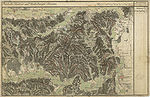
Sausal and Leibnitz around 1790

Sausal, Leibnitz, Unterlauf von Laßnitz and von Sulm, 1879

General map of Central Europe sheet 33 ° 47 ° Graz, 1893


Web links
- 61020 - long. Community data, Statistics Austria .
- Community homepage
- Map of the region
- Internet presence of the culture park Hengist
Individual evidence
- ↑ cadastral communities Styria. 2015 (Excel file, 128 kB); Retrieved July 29, 2015
- ↑ Statistics Austria: Population on January 1st, 2020 by locality (area status on January 1st, 2020) , ( CSV )
- ^ Wilhelm Brandenstein : The mountain and field names in the Granatspitz group (Hohe Tauern). In: Journal for Place Name Research. No. 4 (1928), pp. 155-165. Quoted from: Fritz Freiherr Lochner von Hüttenbach: Wilhelm Brandenstein. Small name-based work. Akademische Druck- und Verlagsanstalt, Graz 1978, ISBN 3-201-01038-3 , pp. 41–52, here: p. 51.
- ↑ Heinz Dieter Pohl: Settlement history and tradition of place names of Slovene origin in East Tyrol and Carinthia (with views of the rest of Austria). In: Peter Ernst, Isolde Hausner, Elisabeth Schuster, Peter Wiesinger (eds.): Place names and settlement history. Files from the symposium of the Working Group for Name Research - Institute for German Studies at the University of Vienna and Institute for Austrian Dialect and Name Lexicons of the Austrian Academy of Sciences from 28-30. September 2000. C. Winter University Press. Heidelberg 2002. pp. 177-189, here: page 178. ISBN 3-8253-1138-4 .
- ↑ Manfred Trummer: Slawische Steiermark = Slightly extended version of the lecture of the same name at the symposium “To be foreign - stay together. The Slovene Ethnic Group in Austria ”as part of the“ Slovene Days ”at the Karl-Franzens University in Graz, 25. – 28. March 1996. From: Christian Stenner (Ed.): Slovenian Styria. Displaced minority in Austria's southeast. Böhlau Verlag, Vienna / Cologne / Weimar 1997, ISBN 3-205-98690-3 , pp. 15–34.
- ^ Wilhelm Brandenstein: Steirisch Lahn - a Celtic word. In: Indo-European Research. Volume 60 (1952). Pp. 21-28. Quoted from: Fritz Freiherr Lochner von Hüttenbach: Wilhelm Brandenstein . Small name-based work. Akademische Druck- und Verlagsanstalt, Graz 1978, ISBN 3-201-01038-3 , pp. 125–132. The word is treated there with Old Irish lan - full and Latin planus - even.
- ↑ a b Gernot Peter Obersteiner: Barracks in the landscape. ( Memento of the original from 23 August 2016 in the Internet Archive ) Info: The archive link was automatically inserted and not yet checked. Please check the original and archive link according to the instructions and then remove this notice. (accessed August 23, 2016).
- ↑ District authority Leibnitz: Ordinance of the district captain of Leibnitz of December 16, 2013 on the declaration of the forest at the Wildoner Buchkogel as a plant protection area. Grazer Zeitung, Official Gazette for Styria. December 20, 2013. Year 2013, 51./52. Piece. ZDB -ID 1291268-2 pp. 722-723.
- ↑ a b Parish Lang: parish council , accessed on June 11, 2015
- ↑ Lang parish, parish coat of arms
- ↑ Kulturpark Hengist, members , accessed on July 3, 2016
- ↑ Grenzlandbote, No. 11 (1979), p. 3.

All Saints' Day at Wildon |
Arnfels |
Ehrenhausen an der Weinstrasse |
Empersdorf |
Gabersdorf |
Gamlitz |
Gleinstätten |
Gralla |
Large small |
Heiligenkreuz am Waasen |
Heimschuh |
Hengsberg |
Kitzeck im Sausal |
Long |
Lebring-Sankt Margarethen |
Leibnitz |
Leutschach an der Weinstrasse |
Oberhaag |
Ragnitz |
Sankt Andrä-Höch |
Sankt Georgen an der Stiefing |
Sankt Johann im Saggautal |
Sankt Nikolai im Sausal |
Sankt Veit in southern Styria |
Schwarzautal |
Straß in Steiermark |
Tillmitsch |
Wagna |
Wildon
50 former communities (dissolved 1945–1969): Aflenz an der Sulm |
Altenberg near Leibnitz |
Badendorf |
Brünngraben |
Feiting |
Felgitsch |
Flamberg |
Liquid |
Gersdorf an der Mur |
Grötsch |
Hart at Wildon |
Hasendorf an der Mur |
Haslach an der Stiefing |
High |
Hut |
Kainach near Wildon |
Labuttendorf |
Landscha on the Mur |
Lappach |
Lebring |
Guide ring |
Lichendorf ** |
Lind near Sankt Veit am Vogau |
Lipsch |
Maggau * |
Marchtring |
Mitteregg |
Nestelberg |
Neudorf an der Mur |
Neudorf im Sausal |
Neutersdorf |
Oberjahring |
Oberschwarza ** |
Ottenberg |
Perbersdorf near Sankt Veit ** |
Pichla at Mureck ** |
Prarath |
Sankt Margarethen bei Lebring |
Shirka |
Schönberg an der Laßnitz |
Schrötten an der Laßnitz |
Seibersdorf near Sankt Veit ** |
Siebing ** |
Sukdull |
House of Commons |
Unterlabill * |
Unterschwarza ** |
Forest chess |
Weitersfeld an der Mur ** |
Wutschdorf 24 former municipalities (dissolved since 2014): Berghausen |
Breitenfeld am Tannenriegel |
Ehrenhausen |
Eichberg-Trautenburg |
Shine on the Wine Route |
Hainsdorf in the Schwarzautal |
Kaindorf an der Sulm |
Leutschach |
Mitterlabill *** |
Murfeld *** |
Pistorf |
Ratsch on the Wine Route |
Retznei |
Sankt Nikolai ob Draßling |
Sankt Ulrich am Waasen |
Sankt Veit am Vogau |
Schlossberg |
Schwarzau in the Schwarzautal *** |
Seggauberg |
Stocking |
Sulztal on the Wine Route |
Weinburg am Saßbach *** |
Weitendorf |
Wolfsberg in the Schwarzautal municipality was at the time of dissolution in: * Feldbach district ; ** Radkersburg district ; *** District of Southeast Styria