Olaya Herrera (Nariño)
| Olaya Herrera | ||
|---|---|---|
|
Coordinates: 2 ° 21 ′ N , 78 ° 20 ′ W Olaya Herrera on the map of Colombia
|
||
|
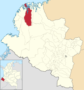
Location of the municipality of Olaya Herrera on the map of Nariño
|
||
| Basic data | ||
| Country | Colombia | |
| Department | Nariño | |
| City foundation | 1975 | |
| Residents | 32,759 (2019) | |
| Detailed data | ||
| surface | 2929 km 2 | |
| Population density | 11 people / km 2 | |
| height | 4 m | |
| Waters | Pacific Ocean , Río Satinga , Río Sanquianga | |
| Time zone | UTC -5 | |
| City Presidency | Elsa Yanett Mosquera Cabezas (2016–2019) | |
| Website | ||
Olaya Herrera is a municipality ( municipio ) in the department of Nariño in Colombia . The main town (cabecera municipal) of Olaya Herrera is Bocas de Satinga . Part of the Sanquianga Natural Park is located in the area of Olaya Herrera .
geography
Olaya Herrera is located in the Tumaco-Barbacoas province in the northwest of Nariño at an altitude of 4 m above sea level. NN , 70 km from Mosquera on the Pacific and has an average temperature of 26 ° C. Bocas de Satinga is located at the confluence of the Río Satinga and Río Sanquianga just before the confluence with the Pacific. The municipality borders the Pacific to the north, Magüí Payán and Roberto Payán to the south, La Tola to the east and Mosquera to the west.
population
The municipality of Olaya Herrera has 32,759 inhabitants, of which 10,395 live in the main town of Bocas de Satinga (as of 2019).
history
The Olaya Herrera Congregation was formed in 1975 and named in honor of Enrique Olaya Herrera .
economy
The main industries of Olaya Herrera are logging , fishing and agriculture (especially rice , cocoa , oranges and corn ).
Infrastructure
There are no reasonable road connections to Olaya Herrera. The most important means of transport is the ship over the various waterways of the municipality.
Web links
- Alcaldía Olaya Herrera - Nariño. Alcaldía de Olaya Herrera - Nariño, accessed on April 3, 2019 (Spanish, website of the municipality).
Individual evidence
- ↑ Information on geography on the website of the municipality of Olaya Herrera (Spanish)
- ↑ ESTIMACIONES DE POBLACIÓN 1985 - 2005 Y PROYECCIONES DE POBLACIÓN 2005 - 2020 TOTAL DEPARTAMENTAL POR ÁREA. (Excel; 1.72 MB) DANE, May 11, 2011, accessed on April 3, 2019 (Spanish, extrapolation of the population of Colombia).
- ↑ Information about the story on the website of the municipality of Olaya Herrera (Spanish)
- ↑ Information on the economy on the website of the municipality of Olaya Herrera (Spanish)
- ↑ Information on the infrastructure on the website of the municipality of Olaya Herrera (Spanish)

