Barbacoas
| Barbacoas | ||
|---|---|---|
|
Coordinates: 1 ° 40 ′ N , 78 ° 8 ′ W Barbacoas on the map of Colombia
|
||
|
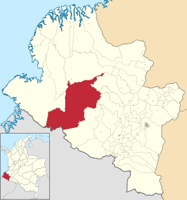
Location of the municipality of Barbacoas on the map of Nariño
|
||
| Basic data | ||
| Country | Colombia | |
| Department | Nariño | |
| City foundation | 1600 | |
| Residents | 41,306 (2019) | |
| City insignia | ||
| Detailed data | ||
| surface | 2324 km 2 | |
| Population density | 18 people / km 2 | |
| height | 36 m | |
| Waters | Telembí River | |
| Time zone | UTC -5 | |
| City Presidency | Eder Escobar Angulo (2016-2019) | |
| Website | ||
Barbacoas is a municipality ( municipio ) in the department of Nariño in Colombia .
geography
Barbacoas is located in the Tumaco-Barbacoas province in the Departamento de Nariño at an altitude of 36 m above sea level. NN , 236 km from Pasto in the Pacific region at the foot of the Western Cordillera of the Colombian Andes and has an average temperature of 26 ° C. The municipality borders Magüí Payán to the north, Los Andes , La Llanada , Samaniego and Ricaurte , im South to Ricaurte and the province of Carchi in Ecuador and to the west to Tumaco and Roberto Payán .
- Community structure
Barbacoas is divided into ten districts (barrios) in the urban part :
- San Antonio
- La Loma
- Guayabal
- El Capricho
- Nueva Granada
- Catalina Nueva
- Paso Grande
- Bello Horizonte
- Uribe Uribe
- San Carlos
In the rural part, the municipality is divided into four populated centers ( centros poblados ), a corregimiento and 15 Indian reservations ( resguardos indígenas ):
Centros poblados :
- Altaquer
- Diviso
- Junín
- Buenavista
Corregimiento :
- Chalalvi
Resguardos indígenas
- Cuambi Yas Lambi
- Pingullo Sardinero
- La Falda Cuas Bil
- Gran Sábalo
- Saunde Guiguay
- Guelmabi Caraño
- Tronqueria Pulgande Palicito
- Chagüi Chimbuza
- Nunabi Alto Ulbí
- Pipalta Palbí Yaguapí
- Piedra Verde
- Tortugaña Punde Brava
- Palví Yagualpí
- Hojal La Turbia
- Alto Albí
population
The municipality of Barbacoas has 41,306 inhabitants, of which 17,807 live in the urban part (cabecera municipal) of the municipality (as of 2019).
history
When the Spaniards arrived, the indigenous peoples of the Barbacoas , Telembies and Iscuandes lived in the area of today's Barbacoas . The area was coveted by the Spaniards because of its large gold deposits , who fought the indigenous peoples, defeated them around 1600 and settled in the newly founded town of Santa Maria del Puerto de los Barbacoas from 1612 . Barbacoas has had parish status since 1916.
economy
The main industries in Barbacoas are agriculture , animal husbandry , mining, and trade . Barbacoas has the largest gold production in Nariño.
Infrastructure
The road that connects Pasto with Tumaco runs through the south of the municipality of Barbacoas and the Corregimiento Junín . The main town can be reached from Junín via an unpaved road. Barbacoas has a river port on the Telembí River .
sons and daughters of the town
- Mateo Cassierra (born 1997), football player
Web links
- Alcaldia Municipal de Barbacoas-Nariño. Alcaldía de Barbacoas - Nariño, accessed April 2, 2019 (Spanish, municipality website).
Individual evidence
- ↑ Geography. Alcaldía de Barbacoas - Nariño, accessed April 2, 2019 (Spanish, information on the geography of the municipality).
- ↑ Plan de desarrollo municipal. (PDF; 4.52 MB) CDIM, accessed on April 3, 2019 (Spanish, community development plan).
- ↑ ESTIMACIONES DE POBLACIÓN 1985 - 2005 Y PROYECCIONES DE POBLACIÓN 2005 - 2020 TOTAL DEPARTAMENTAL POR ÁREA. (Excel; 1.72 MB) DANE, May 11, 2011, accessed on April 2, 2019 (Spanish, extrapolation of the population of Colombia).
- ↑ Nuestra historia. Alcaldía de Barbacoas - Nariño, accessed April 2, 2019 (Spanish, information on the history of the municipality).
- ↑ Nuestro Municipio ( Memento of September 23, 2015 in the Internet Archive )
- ↑ Vías de comunicación. Alcaldía de Barbacoas - Nariño, accessed April 2, 2019 (Spanish, information on the infrastructure of the municipality).


