Tumaco
| San Andrés de Tumaco | ||
|---|---|---|
|
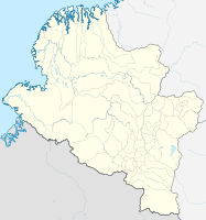
Coordinates: 1 ° 48 ′ N , 78 ° 46 ′ W San Andrés de Tumaco on the map of Nariño
|
||
|
Location of the municipality of Tumaco on the map of Nariño
|
||
| Basic data | ||
| Country | Colombia | |
| Department | Nariño | |
| City foundation | 1640 | |
| Residents | 217,079 (2019) | |
| City insignia | ||
| Detailed data | ||
| surface | 3760 km 2 | |
| Population density | 58 people / km 2 | |
| height | 2 m | |
| Waters | Pacific Ocean , Río Mira | |
| Time zone | UTC -5 | |
| City Presidency | María Emilsen Angulo Guevara (2020-2023) | |
| Website | ||
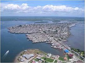
| Aerial photo of Tumaco (2007) | ||
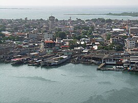
| View of Tumaco | ||
| La Florida Airport | ||
Tumaco or completely San Andrés de Tumaco is a Colombian port city and municipality ( municipio ) in the department of Nariño .
geography
Tumaco is located in the southwest of Colombia in the Tumaco-Barbacoas province in the Departamento de Nariño on the Pacific at an altitude of 1 m above sea level. NN about 304 km from Pasto and has an average temperature of 26 ° C. The municipality borders in the north on Francisco Pizarro and Mosquera , in the south on the province of Esmeraldas in Ecuador , in the east on Barbacoas and Roberto Payán and in the west on the Pacific.
population
The municipality of Tumaco has 217,079 inhabitants, of whom 123,651 live in the urban part (cabecera municipal) of the municipality (as of 2019).
history
Tumaco was founded in 1640 by the Italian priest Francisco Ruggi. Tumaco received parish status in 1861.
The city was repeatedly affected by the armed conflict in Colombia .
On December 12, 1979, the city was hit by the worst earthquake in Colombia to date in the 20th century. A subsequent tsunami destroyed thousands of houses made of wood. The disaster took its place in history as the 1979 Tumaco earthquake .
On August 26, 2009, unknown people murdered twelve Awá indigenous people , including four children.
On February 1, 2012, a motorcycle bomb exploded outside a police station, killing seven people and injuring at least 65. Police General Rodolfo Palomino described the FARC as the perpetrator of the attack.
economy
Tumaco's main industries are agriculture (especially oil palm , cocoa and coconuts ), fishing , timber and tourism. Tumaco also has Colombia's most important Pacific oil port, from which mainly Ecuadorian oil is exported.
Infrastructure
The city's La Florida airport has the IATA code TCO . The airport is served from Bogotá and Cali . There is a direct road connection to Pasto , about 300 km away . After Buenaventura , Tumaco has Colombia's second most important Pacific port.
Tumaco is the seat of the Tumaco diocese . There is also a subsidiary of the Universidad de Nariño in the city .
Town twinning
A city partnership with Montevideo has existed since 2009 .
sons and daughters of the town
- Kevin Angulo (born 1996), soccer player
- Pablo Armero (* 1986), football player
- Alessandro Frigerio (1914–1979), Swiss football player
Web links
- Alcaldia de Tumaco. Alcaldía de Tumaco - Nariño, accessed April 3, 2019 (Spanish, municipality website).
Individual evidence
- ↑ a b c d Nuestro municipio. Alcaldía de Tumaco - Nariño, accessed April 3, 2019 (Spanish, information on the municipality).
- ↑ ESTIMACIONES DE POBLACIÓN 1985 - 2005 Y PROYECCIONES DE POBLACIÓN 2005 - 2020 TOTAL DEPARTAMENTAL POR ÁREA. (Excel; 1.72 MB) DANE, May 11, 2011, accessed on April 3, 2019 (Spanish, extrapolation of the population of Colombia).
- ↑ Sismo del 12 de Diciembre de 1979 en el Pacífico Colombiano gc.gov.co. Accessed May 8, 2020 (es)
- ^ Massacre of Awa indigenous people. In: The Standard . August 27, 2009, accessed February 2, 2012 .
- ↑ Seven dead in a bomb attack in Colombia. In: ORF . February 2, 2012, accessed February 2, 2012 .


