El Charco
| El Charco | ||
|---|---|---|
|
Coordinates: 2 ° 29 ′ N , 78 ° 7 ′ W El Charco on the map of Colombia
|
||
|
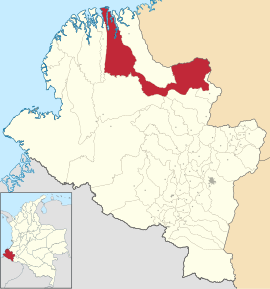
Location of the municipality of El Charco on the map of Nariño
|
||
| Basic data | ||
| Country | Colombia | |
| Department | Nariño | |
| City foundation | 1886 | |
| Residents | 42,525 (2019) | |
| City insignia | ||
| Detailed data | ||
| surface | 2485 km 2 | |
| Population density | 17 people / km 2 | |
| height | 5 m | |
| Waters | Pacific Ocean , Río Tapaje , Río Iscuandé , Río Muchica , Río Sequihonda and Río Amarales | |
| Time zone | UTC -5 | |
| City Presidency | Miltón Cuero Tejada (2016-2019) | |
| Website | ||
El Charco is a municipality ( municipio ) in the department of Nariño in Colombia . In the area of El Charco lies part of the Sanquianga Natural Park .
geography
El Charco is located in the province of Tumaco-Barbacoas in the Departamento de Nariño at an altitude of 5 m above sea level. NN , 465 km from Pasto on the Pacific Ocean and has an average temperature of 28 ° C. Most of the municipality consists of flat coastal land, only the east of the municipality is mountainous and characterized by the western cordillera of the Colombian Andes . The rivers Río Tapaje , Río Iscuandé , Río Muchica , Río Sequihonda and Río Amarales flow through El Charco . The municipality borders in the north on the Pacific Ocean, Santa Bárbara and Guapi in the Departamento del Cauca , in the south on El Rosario , Cumbitara and Magüí Payán , in the east on Leiva and Argelia and Balboa in Cauca and in the west on La Tola .
population
The municipality of El Charco has 42,525 inhabitants, of which 11,663 live in the urban part (cabecera municipal) of the municipality (as of 2019).
history
El Charco was founded in 1886 by Fidel D'Croz and Federico Archer with the name San Juan Bautista . The current name caught on shortly afterwards. El Charco received the status of a municipality in 1967.
economy
The main industries in El Charco are agriculture (especially bananas , coconuts and cocoa ), timber , mining ( gold ) and fishing .
Infrastructure
El Charco has a small airport that is served twice a week from Cali . There are no good road connections to El Charco. There are regular boat connections from Buenaventura , Tumaco , Guapi , La Tola and Olaya Herrera .
Web links
- Alcaldía El Charco Nariño. Alcaldía de El Charco - Nariño, accessed April 3, 2019 (Spanish, municipality website).
Individual evidence
- ↑ a b c d Nuestro municipio. Alcaldía de El Charco - Nariño, accessed April 3, 2019 (Spanish, information on the municipality).
- ↑ ESTIMACIONES DE POBLACIÓN 1985 - 2005 Y PROYECCIONES DE POBLACIÓN 2005 - 2020 TOTAL DEPARTAMENTAL POR ÁREA. (Excel; 1.72 MB) DANE, May 11, 2011, accessed on April 3, 2019 (Spanish, extrapolation of the population of Colombia).


