Ostend (Fulda)
|
Ostend
City of Fulda
Coordinates: 50 ° 32 ′ 54 ″ N , 9 ° 41 ′ 51 ″ E
|
|
|---|---|
| Area code : | 0661 |
|
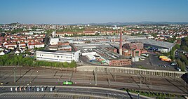
View of the Ostend
|
|
The Ostend is a district of the East Hessian city of Fulda .
location
The Ostend is east of the city center of Fulda. Essentially, the Ostend is delimited by Petersberger-, Künzeller- and Berliner Straße. Berliner Straße, the B 27 , is on a demarcated route.
Socio-cultural composition
The Ostend is a very different area in itself, which consists of completely different sub-quarters.
Basically, the Ostend is a very urban and rather densely built-up area. The area along Petersberger Straße is characterized by dense residential development.
In the area of the so-called musicians' quarter, the residential buildings appear loosened up in some streets through the front gardens of the houses. The so-called Künzeller Höhe is also part of the Ostend. In the former Konrad barracks on Gallasiniring, apartments and service providers from various industries are now housed.
traffic
Transportation
The Ostend is connected to the local public transport via several bus stops. Several city bus routes operate at frequent intervals. After the city bus lines close, the collective call taxi ensures local public transport in Ostend.
Road traffic
In terms of road traffic, the Ostend is mainly accessible via the Künzeller Straße and Petersberg Straße arteries .
Social city
The Ostend, together with the neighboring district of Ziehers Süd, was included in the Social City funding program. An integrated action plan was drawn up for this purpose . In addition, a district office was opened in Ostend.
Individual evidence
- ↑ Integrated action plan - Social City of Fulda. Retrieved May 10, 2020 .
- ↑ Opening times - Social City of Fulda. Retrieved May 10, 2020 .
