
Palu (Elazığ)
| Palu | ||||
|
||||
 Palu with the Murat from the northwest, the castle hill on the left |
||||
| Basic data | ||||
|---|---|---|---|---|
| Province (il) : | Elazığ | |||
| Coordinates : | 38 ° 42 ' N , 39 ° 57' E | |||
| Residents : | 9,504 (2018) | |||
| Telephone code : | (+90) 424 | |||
| Postal code : | 23 500 | |||
| License plate : | 23 | |||
| Structure and administration (as of 2019) | ||||
| Structure : | 10 malls | |||
| Mayor : | Efrayim Ünalan ( AKP ) | |||
| Postal address : | Numune Mahallesi Cumhuriyet Bulvarı No: 4 Kat: 2 23500 Palu / Elazığ |
|||
| Website: | ||||
| Palu County | ||||
| Residents : | 23,834 (2018) | |||
| Surface: | 730 km² | |||
| Population density : | 33 inhabitants per km² | |||
| Kaymakam : | Mustafa Demir | |||
| Website (Kaymakam): | ||||


Palu ( Armenian Բալու Palou ) is a city and capital of the district of the same name in the Turkish province of Elazığ . The city is located around 75 kilometers east of Elazığ and is home to around 40 percent of the district's population (as of the end of 2018).
geography
The Murat river , a source river of the Euphrates , flows through the district from the northeast and forms the Keban reservoir in the southwest of Palus .
location
Palu County is located in the east of the province and borders on Kovancılar County in the north and west, Arıcak and Alacakaya counties in the south, and the Keban Dam reservoir in the south-west and the central district ( Merkez ) of Elazığ form the border. In the east, the district has two districts of the province of Bingöl as neighbors.
district
In 1987, the district gave over half of its territory to the newly formed district of Kovancılar in the north. Most of the 70 or so villages belonged to the then Bucaks Merkez (Palu) and Çaybağı.
At the end of 2018, the district included, in addition to the district town, another municipality ( Belediye ), Beyhan with 4,407 inhabitants. In addition, there are 37 villages ( Köy ) with an average of 268 residents in the district. Baltaşı is the largest village with 1,445 inhabitants. Kayahisar village moved from Arıcak County to Palu County in 2018.
history
The history of Palu goes back to the time of the New Assyrian Empire . King Sulmanu-ašared III. names the area of Palu as the land of Išua . He moved in the middle of the 9th century BC. By Palu against the northern tribes and empires like Urartu . A little later the Urartian king Menua reached the area and left a stele in Eski Palu.
After the Urartians, other peoples and empires ruled here. These included the Macedonians , the Parthians , the Sassanid Empire , the Armenians , Sophene , the Romans , the Byzantine Empire , the Arabs , the Kurds , the Dulkadir , the Aq Qoyunlu and the Ottomans . Since the Ottoman victory over the Safavids in the 16th century , a number of autonomous Kurdish principalities have been established in Eastern Anatolia. Palu was one of those principalities. When the Ottoman Empire lost the First World War on the side of the Central Powers , Palu became part of the new Republic of Turkey in 1923.
Surname
Palu used to be called Palahovid (from Armenian pala-hovid - "Valley of the Pal").
Attractions

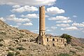
The sights of Palu are all grouped around the castle hill, called Eski Palu (Old Palu) , two kilometers east of the city . The Murat flows around the mountain in a loop.
- Palu Kalesi: The castle of Palu was built by the Urartian king Menua in the 9th / 8th centuries. Century BC Built in BC. In an inscription he names the land of Sebeteria . The castle is on the top of the mountain.
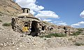
- Cemşit Bey Külliyesi: This Külliye (foundation) was established by the local rulers in the 16th century. The building is located in the west of the mountain and includes a mosque, a madrasa , a Türbe (mausoleum) and a Hazîre (cemetery)
- Küçük Camii (Cami-i Sağir): The Small Mosque is 11 × 11 meters and partially collapsed. It was probably made in the 16th century.
- Ulu Camii (Cami-i Kebir): The construction date of the Great Mosque is unknown, but it is believed to be in Ottoman times. It was restored in 1741. It measures about 24 × 11 meters, instead of a domed roof it had a flat roof, which has collapsed today.
- Hamam: Between the two mosques is a hamam (bath) from 1654, which was built in the classic Ottoman style.
- Kilise: A church ruin, probably from the Byzantine era, with partially preserved wall paintings.
- Palu Köprüsü: According to stories, this bridge over the Murat comes from Roman times, but the architectural style is reminiscent of the Seljuk style . It is therefore believed that it may date from the Ortoqid period (12th to 15th centuries). The Ortoqids probably repaired an older Roman bridge. The bridge is 156.50 m long and 3.5 m wide. In 2010 the bridge was restored. It is passable and connects the modern road in the east with the castle hill.

Bridge over the Murat with the church in the background

Küçük Camii
Ulu Camii
Hammam

church


Personalities
- Selahattin Demirtaş (* 1973), politician and presidential candidate of Halkların Demokratik Partisi (HDP)
- Melkon Gürdjian (1859–1915), Armenian writer and victim of the Armenian genocide
- Yusuf Harputlu (* 1981), singer
Web links
Individual evidence
- ↑ a b Türkiye Nüfusu İl ilçe Mahalle Köy Nüfusları , accessed on June 12, 2019
- ↑ König 1955/57, No. 35
- ^ Anatolic index
- ↑ CA Burney: Urartian Fortresses and Towns in the Van Region , Anatolian Studies , Vol. 7 (1957), pp. 37-53.
- ↑ Description on site
- ↑ Description on site
- ↑ Description on site
