
Elazığ
| Elazığ | ||||
|
||||
 İzzet Pasha Mosque and Gazi Caddesi in the center of Elazığ |
||||
| Basic data | ||||
|---|---|---|---|---|
| Province (il) : | Elazığ | |||
| Coordinates : | 38 ° 40 ' N , 39 ° 13' E | |||
| Height : | 1067 m | |||
| Residents : | 377,906 (2019) | |||
| Telephone code : | (+90) 424 | |||
| Postal code : | 23,000 | |||
| License plate : | 23 | |||
| Structure and administration (as of 2019) | ||||
| Structure : | 38 Mahalle | |||
| Mayor : | Şahin Şerifoğulları ( AKP ) | |||
| Website: | ||||
| Elazığ County | ||||
| Residents : | 439,687 (2019) | |||
| Surface: | 2,243 km² | |||
| Population density : | 196 inhabitants per km² | |||


Elazığ ([ 'elazɯː ]; formerly Ottoman معمورة العزيز Mamûret'ül-Azîz , tooالعزیز Elaziz called, Kurdish Elezîz) is a city in Turkey with 568,239 inhabitants (2014). It is the provincial capital of the province of the same name Elazığ and is 1067 m above sea level. At the same time, it is also the center of the central district ( Merkez ).
geography
location
The central district (Merkez) Elazığ is located in the middle of the province. In the west it borders on the Baskil and Keban districts , in the north on the Pertek district of the Tunceli province , in the west on the districts of Kovancılar , Palu and Maden and on the Sivrice district in the south. In the north and east, the water surface of the Keban Dam (total area about 675 km²) form the borders.
district
The central district is the largest of all eleven districts in the province in terms of size (about a quarter of the province's area) and population (about 70 percent of the provincial population). With a population density of 188 inhabitants per square kilometer, it is almost three times the provincial average (2018: 63.5).
In addition to the district town, it consists of four other municipalities ( Belediye ): Yazıkonak (9,057), Yurtbaşı (7,996), Akçakiraz (7,929) and Mollakendi (2,892 pop.). There are also 135 villages ( Köy ) with an average of 298 residents. Four villages have more than a thousand inhabitants: Şahinkaya (1,520), Kuyulu (1,321), Hankendi (1,097) and Yemişlik (1,044 inh .). The village of Bahçekapı (2017: 1,032 inh .) Became a mahalle (district) of the municipality of Akçakiraz (2018: 1,050 in.) In 2018.
population
Turks , Kurds and Zazas live in Elâzığ . Until the First World War there was a large Armenian community , but the Armenian Genocide fell victim in 1915.
Population development
The following table shows the comparative population level at the end of the year for the province, the central district and the city of Elazığ as well as the respective share at the higher administrative level. The figures are based on the address-based population register (ADNKS) introduced in 2007.
| year | province | district | city | ||
|---|---|---|---|---|---|
| real | % | real | % | real | |
| 2018 | 595,638 | 70.80 | 421.726 | 83.85 | 353,629 |
| 2017 | 583,671 | 75.03 | 437,951 | 87.18 | 381,794 |
| 2016 | 578,789 | 74.52 | 431.294 | 86.79 | 374.319 |
| 2015 | 574,304 | 73.98 | 424.870 | 86.42 | 367.156 |
| 2014 | 568,753 | 72.48 | 412.220 | 85.27 | 351.504 |
| 2013 | 568.239 | 70.06 | 398.108 | 83.60 | 332.810 |
| 2012 | 562.703 | 72.21 | 406,300 | 85.62 | 347.857 |
| 2011 | 558,556 | 71.73 | 400,640 | 85.17 | 341.220 |
| 2010 | 552,646 | 70.90 | 391.811 | 84.60 | 331.479 |
| 2009 | 550,667 | 69.95 | 385.167 | 83.97 | 323.420 |
| 2008 | 547,562 | 68.58 | 375,534 | 83.24 | 312,584 |
| 2007 | 541.258 | 69.42 | 375.715 | 85.01 | 319,381 |
Census results
The following population information about the city, the district, the province and the country is available for the censuses:
| region | 1965 | 1970 | 1975 | 1980 | 1985 | 1990 | 2000 |
|---|---|---|---|---|---|---|---|
| City (Şehir) | 78,605 | 107.364 | 131,415 | 142,983 | 182.296 | 204.603 | 266,495 |
| central circle (Merkez) | 142,361 | 175,444 | 203,417 | 220.053 | 251.097 | 272.812 | 344,698 |
| Province (İl) | 322,727 | 376.915 | 417.924 | 440,808 | 483.715 | 498.225 | 569,616 |
| Turkey | 31,391,421 | 35.605.176 | 40,347,719 | 44,736,957 | 50,664,458 | 56.473.035 | 67,803,927 |
history
Elâzığ was initially just a hamlet near the city of Harput , which increasingly lost its importance in the 19th century. Elâzığ was then called Agavat mezrası .
The local Ottoman governor (tr: Vali ), Reşid Mehmed Pascha, expanded the hamlet into a city. Barracks, a hospital and a governor's seat were built under Sultan Abdülaziz . In 1866 the city was named in honor of Sultan Abdülaziz and his five-year reign in Mamûret'ül-Azîz /معمورة العزيزrenamed. The name means "enriched by Abdülaziz". In 1878 three districts were separated from the Diyarbekir province and the new Mamûret'ül-Azîz province was founded.
The most important event in the first years of the republic was the capture of the city on February 24, 1925 by insurgent troops during the Sheikh Said uprising . It remained in the hands of the insurgents until the end of June.
At the first census in 1927, the city had fewer than 20,000 inhabitants. In 1934 it was connected to the railway network. The name Mamûret'ül-Azîz was shortened to Elâzîz . In November 1937, the Council of Ministers renamed the city Elazık , which was changed to the current form Elâzığ in December 1937 . In 1936 it was temporarily the administrative seat of two provinces, since the newly created Tunceli province was also administered from Elâzîz. The population grew rapidly, and in 1970 more than 100,000 residents were registered for the first time.
religion
The grounds of the Armenian Evangelical Church in the city center are currently used as a car park.
Climate table
| Elazığ (881 m) | ||||||||||||||||||||||||||||||||||||||||||||||||
|---|---|---|---|---|---|---|---|---|---|---|---|---|---|---|---|---|---|---|---|---|---|---|---|---|---|---|---|---|---|---|---|---|---|---|---|---|---|---|---|---|---|---|---|---|---|---|---|---|
| Climate diagram | ||||||||||||||||||||||||||||||||||||||||||||||||
| ||||||||||||||||||||||||||||||||||||||||||||||||
|
Average monthly temperatures and rainfall for Elazığ (881 m)
|
||||||||||||||||||||||||||||||||||||||||||||||||||||||||||||||||||||||||||||||||||||||||||||||||||||||||||||||||||||||||||||||||||||||||||||||||||||||
Sports
Elâzığ is the seat of the Elazığspor football club , which plays in the TFF 1st Lig .
Attractions
Since Elâzığ is a relatively young city, there are no old buildings. Most of the buildings listed here are in Harput.
- Harput Kalesi (Harput Castle)
- Ulu Cami from 1156. Erected by the Ortoqids under Sultan Fahrettin Karaaslan.
- Sarahatun Camii from 1465. It was built by Sara Hatun, Uzun Hasan's mother .
- Kurşunlu Cami from 1738/1739
- Ağa Camii from 1559.
- Arap Baba Mescidi ve Türbesi, a tomb from the Seljuk era from 1279. It contains the tomb of a saint.
traffic
The Elazig airport serves domestic and international destinations.
gallery
Elâzığ station building with forecourt

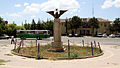
Street scene in the center of Elâzığ
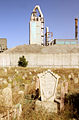
Old cemetery in southern Elâzığ, with a cement factory in the background

The Saray Mosque in the city center


Web links
Individual evidence
- ↑ a b Türkiye Nüfusu İl ilçe Mahalle Köy Nüfusları , accessed on April 13, 2020
- ↑ Central Dissemination System / Merkezi Dağıtım Sistemi (MEDAS) of the TÜIK , accessed on June 12, 2019
- ↑ Genel Nüfus Sayımları (census results 1965 to 2000) , accessed June 12, 2019
- ↑ Elazığ'da kiliseden bozma otopark. Retrieved April 11, 2014 .
