Panneschopp
|
Panneschopp
City of Geilenkirchen
Coordinates: 50 ° 58 ′ 1 ″ N , 6 ° 4 ′ 16 ″ E
|
|
|---|---|
| Height : | 86 (84-87) m |
| Residents : | 29 (Nov. 30, 2012) |
| Postal code : | 52511 |
| Area code : | 02451 |
|
Location of Panneschopp in Geilenkirchen
|
|
|
Entrance
|
|
Panneschopp is a district of the town of Geilenkirchen in the district of Heinsberg in North Rhine-Westphalia .
geography
location
Panneschopp is about three kilometers west of the city center of Geilenkirchen. The Geilenkirchen Air Base is located nearby .
Waters
The place belongs to the catchment area of the Rodebach which drains into the Meuse (GEBKZ 28182211, GEWKZ 281822).
Neighboring places
| Niederbusch | Gillrath | Niederheid |

|
Nierstrass | |
| Teveren |
Type of settlement
Panneschopp is a loosely built hamlet .
history
Panneschopp is a place that was only created in the 19th century. Panneschopp is not yet listed in the description of the Royal Prussian Rhine Province from 1830. The first name can be found on the original cadastral map from 1846, where the place is entered on the Pannenschop . The name goes back to the vernacular term Pannenschop for "(roof) pan shed" and originated in the first half of the 19th century with the establishment of the roof tile distillery in the area. In 1893 the current name Panneschopp was used.
In the course of the regional reform on January 1, 1972, the places Gillrath, Hatterath, Nierstrasse and Panneschopp remained with the city of Geilenkirchen.
Church history
The place belongs to the Catholic parish of St. Marien in Gillrath , the population is predominantly Catholic.
politics
According to § 3 (1) b) of the main statute of the city of Geilenkirchen, the places Gillrath, Hatterath, Nierstraß and Panneschopp form a city district. He is represented by a local mayor in the city council of Geilenkirchen. The head of the district is Franz Beemelmanns. Stand 2013
Attractions
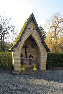
Wegekapelle Panneschopp: The small Roman Catholic chapel is located in the district of Panneschopp at number 33 on a fortified square. It was built in 1964 by the residents of the village and is ecclesiastically assigned to the parish of Gillrath . The building is a simple brick building with a pointed roof, inside there is a simple crucifix .
Infrastructure
- In November 2012, 29 people lived in Panneschopp.
- The Panneschopp nature reserve is immediately adjacent to the development .
- The place has a connection to the cycling network NRW .
School system
- Gillrath primary school, also for Panneschopp 1925: 4 classes, 3 levels, 2 teachers, 2 teachers, 171 children
- Elementary school Gillrath, also for Panneschopp 1965: 4 classes, 4 teaching positions, 138 children
Street names
In Panneschopp there are no street names, only house numbers .
literature
- Handbook of the Diocese of Aachen. 3. Edition. Kühlen, Mönchengladbach 1994, ISBN 3-87448-172-7 , pp. 704-706
- Friedrich von Restorff : Topographical-statistical description of the Royal Prussian Rhine Province . Nicolai, Berlin and Stettin 1830
Web links
- Website of the city of Geilenkirchen
- Monuments in the city of Geilenkirchen
- Churches and chapels in the city of Geilenkirchen
Individual evidence
- ^ German basic map 1: 5000
- ↑ Archived copy ( memento of the original from October 17, 2013 in the Internet Archive ) Info: The archive link was inserted automatically and has not yet been checked. Please check the original and archive link according to the instructions and then remove this notice.
- ↑ http://www.lanuv.nrw.de/fileadmin/lanuv/wasser/pdf/Gewaesserverzeichnis%20GSK3C.xls
- ↑ Joseph Gotzen: The place names of the Geilenkirchen district in connection with the history of the settlement , Verlag E. van Gils, 1926, p. 97
- ^ Main statute of the city of Geilenkirchen
- ↑ Handbook of the Diocese of Aachen , Third Edition, 1994, ISBN 3-87448-172-7
- ↑ http://www.naturschutz-fachinformationssysteme-nrw.de/nsg/de/fachinfo/ regions/ overall/ HS_013


