Waurichen
|
Waurichen
City of Geilenkirchen
Coordinates: 50 ° 56 ′ 46 ″ N , 6 ° 9 ′ 25 ″ E
|
|
|---|---|
| Height : | 110 (108-111) m |
| Residents : | 767 (Nov. 30, 2012) |
| Postal code : | 52511 |
| Area code : | 02451 |
|
Location of Waurichen in Geilenkirchen
|
|
|
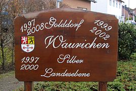
Gold and silver village Waurichen
|
|


Waurichen is a district of the middle town of Geilenkirchen in the Heinsberg district in North Rhine-Westphalia .
history
location
Waurichen is located southeast of Geilenkirchen on federal highway 56 . State road 240 , which connects Geilenkirchen with Baesweiler , runs in the south-west of Waurichen .
Neighboring places
| Hünshoven | Bumpers | Immendorf |
| Frelenberg |

|
Puffendorf |
| Ubach | Beggendorf | Floverich |
Type of settlement
Waurichen is a two-line, loosely built street village . The place and the surrounding area are rural.
history
Place name
- 1279 (de) Wauderike
- 1300 Waylderych
- 1462 Waerick
- 1518 Waurich
- 1666 Waurich
Local history
Waurichen belonged to the Jülich office of Geilenkirchen . Before 1300, the Heinsberg Norbertine monastery in Waurichen had income that can no longer be proven later. Heinsberg fiefs , including the Lathof, were also in Waurichen. They later appeared as a fiefdom of the Geilenkirchen man chamber . The Lathof was considered a sub- fief of Breill Castle . Jokingly, there is a sign at the entrance to Haus Breill: Breill is a suburb of Waurichen.
In 1828 Waurichen had a total of 328 inhabitants, in 1852 there were 372 inhabitants and belonged to the Immendorf mayor . In the course of the regional reform , the Immendorf- Würm office was dissolved on January 1, 1972 . The legal successor is the city of Geilenkirchen § 29 Aachen Law (1971) .
Waurichen is a permanent participant in the competition Our village has a future . In 1997, 1999, 2002 and 2008 the place was awarded the gold medal at the district level . At the state level, a silver medal was won in 1997 and 2000 .
Church history
Waurichen forms the parish Immendorf with Immendorf and Apweiler . The majority of the population consists of Catholics . In the course of the parish reforms in the Diocese of Aachen , the formerly independent Catholic parish of St. Peter Immendorf was incorporated into the Community of Parishes (GdG) St. Bonifatius Geilenkirchen.
Attractions
- Water pump in Brunnenstrasse as monument no.19
- Hofanlage, Walderych 56 as monument no.43
- Fallen memorial on Brunnenstrasse
- Crossroads at the entrance to the village
Infrastructure
- In November 2012 there were 767 people living in Waurichen.
- There are several farms, some with animal husbandry , a wine shop , a roofer , a service for nursing and care for the elderly , as well as some small businesses.
- A bus stop on line 71 in the AVV Geilenkirchen- Aldenhoven and back.
- Two playgrounds, on Langgasse and at the community center
- Connection to the NRW cycling network
- Fire brigade of the Geilenkirchen volunteer fire brigade, Waurichen fire fighting group
societies
- Interest group of the local associations in the parish Immendorf, Waurichen, Apweiler
- Volunteer fire brigade Geilenkirchen fire fighting group Waurichen
- IG Village Renewal Waurichen
- St. Hubertus Schützengesellschaft Waurichen 1923 eV
- Sportschützen Waurichen 1989 eV
- Rifle Corps Waurichen 1922
- Carnival society "Lott se loope" Immenwauweiler
- Knotzelimer Carnival Club 1992 Waurichen
- Interest group "Old Tractors" eV
- Theater association “Fidele Bühne” Waurichen
- Tupp Club Waurichen
Regular events
- Rose Monday procession of KG Immenwauweiler
- Patronage festival and summer fair
- St. Martin parade in Waurichen
- King bird shot
- Theatrical performance
Street names
Auf dem Göß, Auf dem Jück, Beggendorfer Straße, Brunnenstraße, Hasselter Straße, Langgasse, Römerstraße, Walderych
gallery
literature
- Friedrich von Restorff : Topographical-statistical description of the Royal Prussian Rhine Province . Nicolai, Berlin and Stettin 1830
- Leo Gillessen: The localities of the district of Heinsberg , p. 126
- Leo Gillessen: On place names and settlement studies of the southern Selfkant district , in: Home calendar of the Selfkant district Geilenkirchen-Heinsberg 1970, pp. 38–49
Web links
- Website of the city of Geilenkirchen
- Monuments in the city of Geilenkirchen
- Churches and chapels in the city of Geilenkirchen
Individual evidence
- ^ German basic map 1: 5000


