Niederheid
|
Niederheid
City of Geilenkirchen
Coordinates: 50 ° 58 ′ 58 ″ N , 6 ° 6 ′ 20 ″ E
|
|
|---|---|
| Height : | 90 (88-92) m |
| Residents : | 891 (Nov. 30, 2012) |
| Postal code : | 52511 |
| Area code : | 02451 |
|
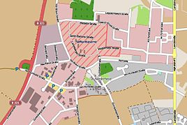
Location of Niederheid in Geilenkirchen
|
|
|
Local development in Niederheid
|
|

Niederheid is a district of the medium- sized town of Geilenkirchen in the Heinsberg district in North Rhine-Westphalia .
geography
location
Niederheid is located about one and a half kilometers north of the core city of Geilenkirchen on the federal road 221 , which runs from Straelen in the Kleve district via Heinsberg and Geilenkirchen to Alsdorf in the Aachen city region . The street is now used as a bypass around the town and town. The actual core of the formerly small hamlet was formed by a few larger courtyards, which were located in the manner of a forest hoof village on the south side of today's Von-Humboldt-Straße, which branches off at right angles from the "Landstraße", a path that connected Trips Castle to Gillrath via Niederheid through the village pond on the north side. Behind the courtyards there was a fenced-in meadow in the courtyard strip, then the field followed (Heyder Feld). Some of the former striped corridors can still be explored using the paths in the tranchot map. The area north of the road is referred to as heather (Bruyères, Br) on the Tranchot map , interspersed with moorland (Marais, M), hence the many former waterholes that remained when peat was extracted . Today the face of the place has changed. The heathland favored the settlement of military and industry. Today the place is surrounded by three industrial areas. The corresponding north-eastern Geilenkirchen district of Hochheid has largely been able to retain its character.
Waters
In heavy rain and when snowmelts , the surface water flows from Niederheid and Rischden to the Kötteler Schar (GEWKZ 282894). The brook runs past Uetterath , through Dremmen and flows into the Wurm at Grebben after a length of 9.498 km .
Neighboring places
| Hatterath | Rischden | Tripsrath |
| Gillrath |

|
Müllendorf |
| Nierstrass | Bellyem | Süggerath |
history
Place name
- 1498 op der Heyden
- 1590 on the Heyden
- 1666 Dorff Heydt
- 1820 Nieder Heyde
Local history
Niederheid used to belong to the Jülich office of Geilenkirchen. The place also belonged to the court and the parish of Geilenkirchen.
Niederheid had a total of 115 inhabitants in 1828 and 239 in 1852. In the course of the regional reform on January 1, 1972, Niederheid remained with the city of Geilenkirchen.
Church history
The majority of the population consists of Catholics . The place belongs to the parish of St. Mariä Himmelfahrt, Geilenkirchen.
politics
According to § 3 (1) h) of the main statute of the city of Geilenkirchen, Niederheid is a city district. This is represented by a mayor in the city council of Geilenkirchen.
Attractions
- Lambertus Chapel from 1905.
Infrastructure
- In November 2012 there were 891 people living in Niederheid.
- There are three industrial areas in Niederheid, in which numerous companies with the following mix of industries are represented: Construction industry * automotive suppliers * construction industry * building installation * service center * iron and plumbing wholesale * catering equipment * trading companies * motor vehicle trade * plastics processing industry * metal processing * software developer.
- The AVV , serves the place with the lines 410, 434 and 437.
- The kindergarten Die Waldwichtel is in the Selfkant barracks on Quimperlestrasse.
- A playground in Niederheid is located on Von-Humboldt-Straße
- The place has a connection to the cycling network NRW .
- The Bundeswehr's verification center is located in the Selfkant barracks in Niederheid .
- Fire brigade of the Geilenkirchen volunteer fire brigade, Niederheid fire fighting group
societies
- Volunteer fire brigade Geilenkirchen, Niederheid fire fighting group
- Spielmannszug 1920 Niederheid eV
- Malteser Hilfsdienst e. V. Niederheid district office
- Friends of Quimperlé 1990 Niederheid eV
Street names
Am Dorfteich, Am Forsthaus, An Fürthenrode, Aufm Brunk, August-Thyssen-Straße, Borsigstraße, Daimlerstraße, Dieselstraße, Einsteinstraße, Fort-Sill-We, Friedrich-Krupp-Straße, Gutenbergstraße, Hansemannstraße, Huntsville Weg, Junkersstraße, Kapellenweg, Landstraße , Leopold-Hoesch-Strasse, Matadorstrasse, Ottostrasse, Pater-Esser-Weg, Pershing Allee, Quimperlestrasse, Richtweg, Röntgenstrasse, Sankt-Barbara-Strasse, Von-Braun-Strasse, Von-Humboldt-Strasse, Zeppelinstrasse
literature
- Handbook of the Diocese of Aachen. 3. Edition. Kühlen, Mönchengladbach 1994, ISBN 3-87448-172-7 , pp. 702-704
- Leo Gillessen: The localities of the district of Heinsberg. Heinsberg 1993, ISBN 3-925620-13-3 , p. 133
- Friedrich von Restorff : Topographical-statistical description of the Royal Prussian Rhine Province . Nicolai, Berlin and Stettin 1830, OCLC 165725051
Web links
- Website of the city of Geilenkirchen
- Monuments in the city of Geilenkirchen
- Churches and chapels in the city of Geilenkirchen
Individual evidence
- ^ German basic map 1: 5000
- ↑ The K 4 from Straeten to Tripsrath , which runs a few kilometers to the north, is called Waldhufenstraße
- ↑ http://www.lanuv.nrw.de/fileadmin/lanuv/wasser/pdf/Gewaesserverzeichnis%20GSK3C.xls
- ^ Main statute of the city of Geilenkirchen
- ↑ http://www.esc-geilenkirchen.de/go/die_drei_gewerbegebiete.html
- ↑ Archived copy ( memento of the original from September 6, 2013 in the Internet Archive ) Info: The archive link was inserted automatically and has not yet been checked. Please check the original and archive link according to the instructions and then remove this notice.


