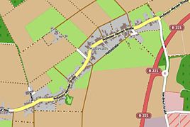
Hatterath
|
Hatterath
City of Geilenkirchen
Coordinates: 50 ° 59 ′ 22 ″ N , 6 ° 5 ′ 25 ″ E
|
|
|---|---|
| Height : | 88 (85-90) m |
| Residents : | 425 (Nov. 30, 2012) |
| Postal code : | 52511 |
| Area code : | 02451 |
|
Location of Hatterath in Geilenkirchen
|
|
|
Entering Hatterath from Gillrath
|
|

Hatterath is a district of the middle town Geilenkirchen in the district of Heinsberg in North Rhine-Westphalia .
history
location
Hatterath is about three kilometers northwest of the city center of Geilenkirchen near the federal highway 221 ,
Waters
Hatterath belongs to the catchment area of the Rodebach which flows into the Meuse . (GEBKZ 28182211, GEWKZ 281822)
Neighboring places
| Birgden | Straeten | Uetterath |
| Stand |

|
Tripsrath |
| Gillrath | Nierstrass | Niederheid |
Type of settlement
Hatterath is a loosely built street village .
history
Place name
- 1337 Atrade
- 1342 Hatrade
- 1344 (de) Atrode
- 1483 Hatterae
- 1515 Hatterae
- 1820 Hatterath
Local history
Hatterath used to belong to the Jülich office of Geilenkirchen. In the 14th century, the Heinsberger Norbertinerstift received income from Hatterath. Little is known about the history of the place.
In 1828 Hatterath had a total of 167 inhabitants, in 1852 there were 210 inhabitants. In the course of the regional reform on January 1, 1972, the places Gillrath, Hatterath, Nierstrasse and Panneschopp remained with the city of Geilenkirchen.
Church history
The parish of St. Marien Gillrath is made up of the villages of Gillrath, Hatterath, Nierstrasse and Panneschopp. The majority of the population consists of Catholics .
Until the end of the 18th century the place belonged to the parish of Geilenkirchen. When the first diocese of Aachen was organized in 1804, Gillrath became a parish in the canton of Geilenkirchen. The first pastor was Heinrich Joseph Aretz. After the archdiocese of Cologne was re-established in 1827, the canton became the deanery of Geilenkirchen. Since then the parish has belonged to this deanery.
Around 1790 a single-nave hall church with a three-sided choir was built in Gillrath in the west. In 1846 a two-story tower was added. On June 12, 1851 was the ceremonial inauguration of the church. After 1922 the church was expanded.
In the course of the parish reforms in the Diocese of Aachen, the formerly independent Catholic parish of St. Marien Gillrath was incorporated into the Community of Parishes (GdG) St. Bonifatius Geilenkirchen .
politics
According to § 3 (1) b) of the main statute of the city of Geilenkirchen, the places Gillrath, Hatterath, Nierstraß and Panneschopp form a city district. He is represented by a local mayor in the city council of Geilenkirchen. The head of the district is Franz Beemelmanns. Stand 2013
Attractions
- Kreuzkapelle in Hatterath on Professor-Mendel-Strasse, built in 1740
- St. Peter and Paul Chapel on Salzweg, built in 2010
- Hatterath village chapel on Hattostraße, built in 1908
- Three crossroads in Hatterath
Infrastructure
- In November 2012 there were 425 people living in Hatterath.
- Hatterath is served by line 434 (Geilenkirchen- Höngen ) at three stops in the AVV bus service.
- There is a playground in Hatterath on Professor-Mendel-Straße.
- The place has a connection to the cycling network NRW .
School system
- Gillrath primary school, also for Hatterath 1925: 4 classes, 3 levels, 2 teachers, 2 teachers, 171 children
- Elementary school Hatterath 1965: 1 class, 1 teaching position, 40 children
societies
- Geilenkirchen volunteer fire brigade , Gillrath-Hatterath fire fighting group
- Interest group of the associations in Hatterath eV
- Hatterather Carnival Association "De Schanzremmele" eV
- Schützenbruderschaft St. Peter and Paul Hatterath eV
- VDK local association Gillrath, also for Hatterath
Street names
Hattostrasse, Professor-Mendel-Strasse, Salzweg, Zum Hahnhof
literature
- Handbook of the Diocese of Aachen. 3. Edition. Kühlen, Mönchengladbach 1994, ISBN 3-87448-172-7 , pp. 704-706
- Leo Gillessen: The localities of the district of Heinsberg , p. 120
- Friedrich von Restorff : Topographical-statistical description of the Royal Prussian Rhine Province . Nicolai, Berlin and Stettin 1830
Web links
- Website of the city of Geilenkirchen
- Monuments in the city of Geilenkirchen
- Churches and chapels in the city of Geilenkirchen
Individual evidence
- ^ German basic map 1: 5000
- ↑ Archive link ( Memento of the original from October 17, 2013 in the Internet Archive ) Info: The archive link was inserted automatically and has not yet been checked. Please check the original and archive link according to the instructions and then remove this notice.
- ↑ http://www.lanuv.nrw.de/fileadmin/lanuv/wasser/pdf/Gewaesserverzeichnis%20GSK3C.xls
- ^ Main statute of the city of Geilenkirchen


