Pausdorf
|
Pausdorf
City of Scheßlitz
Coordinates: 50 ° 0 '38 " N , 11 ° 2' 34" E
|
|
|---|---|
| Height : | 392 m |
| Residents : | 102 |
|
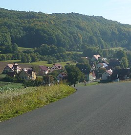
View of Pausdorf from the west (2012)
|
|
Pausdorf has been a district of Scheßlitz in the Upper Franconian district of Bamberg with around 100 inhabitants since 1972 .
geography
The village is located in the Franconian Alb , about four kilometers north of Scheßlitz in the valley of the Krebsbach at an altitude of 392 m above sea level. NN .
history
The Bavarian original cadastre shows Pausdorf in the 1810s as a village with 21 hearths.
In the area of the village cross is the Immaculate Conception chapel, which was built in 1903 and is a listed building. In addition to the church, around half a dozen farmhouses and stables from the 17th to 19th centuries have been preserved in the village. See also: List of architectural monuments in Pausdorf
In the course of the regional reform in Bavaria , the village was incorporated into Scheßlitz in 1972.
Web links
Individual evidence
- ↑ Pausdorf on Bayern Atlas Classical
- ↑ Chapel of the Immaculate Conception in Pausdorf. Catholic Parish Office St. Kilian, accessed on November 12, 2018 .
- ↑ a b LfD list for Scheßlitz (.pdf)

