
Peneda-Gerês National Park


The Peneda-Gerês National Park ( Portuguese : Parque Nacional da Peneda-Gerês ), also known simply as Gerês , is the only national park in Portugal and is located in the Norte region in the north-west of the country. There are also many nature parks, protected landscapes and reserves across the country.
With national and international participation, the park was founded on May 8th, 1971 to protect and preserve the soil, water, flora , fauna and landscape. Education and tourism are also goals of the park. Since 2009, the National Park is part of a biosphere reserve of UNESCO .
geography

The districts of Viana do Castelo (with the cities of Melgaço , Arcos de Valdevez , Ponte da Barca ), Braga and Vila Real share the park. It has an area of 702.90 km². 52.75 km² of it are public property, 194.38 km² are private property and the remaining 455.77 km² are common land .
5,000 hectares in the core zone of the national park are among the wilderness areas certified by the European Wilderness Society .
According to a census from 1991 there were 9099 inhabitants, 16% less than the 10849 registered in 1981. They live in around 114 villages.
The horseshoe-shaped park surrounds the eponymous mountain ridges ( Serras ) da Peneda and do Gerês , as well as the Serra do Soajo and da Amarela . The highest peaks are Peneda (1373 m), Nevosa (1545 m) and Altar dos Cabrões (1538 m), which lie on the Spanish border ( Serra do Xurés ). Other mountains are Giesto (1337 m), Outeiro Alvo (1314 m), Pedrara (1416 m), Lourica (1355 m), Borrageiro (1433 m) and Fornos da Fonte Fria (1456 m). The park's border with Spain is 80 km long.
The large number of streams, waterfalls, mountain and reservoirs make the evergreen park one of the most beautiful on the Iberian Peninsula. Several rivers cross it: Cávado , Lima , Homem , Rabagão , Castro Laboreiro and Arado . The rivers have dams with the following names:
- Cávado: Caniçada , Salamonde , Paradela
- Homem: Vilarinho das Furnas
- Lima: Alto-Lindoso
- Rabagão: Alto Rabagão , Venda Nova
Farmland also belongs to each of the villages in the highlands. In view of the mountainous landscape, it is built in terraces to make better use of the barren land. Many traditional houses have granite walls and thatched roofs . They give the landscape and some of the remote villages such as Pitões das Júnias and Ermida their special charm.
In the highlands there is an average temperature of around 10 ° C, fluctuating between 4 and 14 ° C. The average rainfall is more than 2500 mm / year with more than 130 rainy days. Snow is common in winter. The river valleys of the Homem and Cávado have a milder climate, with temperatures between 8 and 20 ° C (average 14 ° C). The annual precipitation of 900 mm with 100 rainy days also deviates from the average of the area.
geology


The park's mountains were formed between 380 and 280 million years ago, from the Devonian to the Permian period . The mountain peaks are dominated by granite rocks , the oldest of which on Amarela , dated around 310 million years. There are mineral veins of tin . Tungsten , molybdenum and gold were mined in the now closed Carris and Borrageiro mines . Mostly on the northwestern surveys on Castro Laboreiro , enter mica schist and quartz to light.
Some valleys show signs of glacial influence through the ice ages of the Pleistocene .
flora

The valleys have lush vegetation. In particular, some types of oak ( English oak , Pyrenees oak , Portuguese oak and others), prunus , holly , eucalyptus , mulberry and strawberry trees , sweet chestnuts and birches are widespread . Yew trees and sand birches stand by the rivers .
As the terrain rises, the vegetation becomes bare due to the harsher climate. Heather , gorse and juniper grow here .
Corn is the main agricultural product.
fauna

The confusing, mountainous terrain offers ideal living conditions for many wild animals such as deer , wild boars , wild cats , foxes , otters , wolves , pine martens and squirrels ; Birds such as red kites , buzzards , golden eagles , goshawks , eagle owls , falcons and whinchat . Reptiles such as real vipers , adders, and lizards ; and amphibians such as newts , salamanders and common disc bangers .
The brown bear was exterminated in the region in the 17th century. The extinct Pyrenean ibex was last seen in the 1890s .
Many animal species find one of their last places of refuge on Gerês, not only in Portugal, but on the entire Iberian Peninsula . Wolves and golden eagles , which are seen as a threat to livestock, have been virtually wiped out by hunting and have been protected by law since the end of the 20th century.
The Garranos , a kind of small horse, should also be mentioned . They mostly live in the wild, but have not been afraid of people since they were domesticated.
Two other local breeds of domesticated animal species are now seriously threatened: the two cattle breeds Cachena and the larger Barrosã were once used in agriculture. They are at risk these days because they have lost their use. The Cão de Castro Laboreiro , a hunting dog , is also not as common today as it was before.

Sign at an entrance to the national park
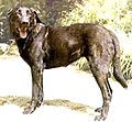
Cão de Castro Laboreiro


history
The oldest witnesses of human settlement are the 5000 year old dolmens at Castro Laboreiro , Mourela , Mezio , Paradela , Cambeses , Pitões and Tourem . The menhir of Ermida is at Ponte da Barca .
Various Roman roads such as the Roman Geira cross the park and testify to the Roman settlement with milestones and bridges. One of the streets connected Astorga (Spain) with Braccara Augusta (now Braga , Portugal). Large sections of the Rio Homem are still well preserved.
From the 20th century on, it was common for the mountain population to live in two separate villages, mostly near Castro Laboreiro : In summer in the upper village, often above 1,000 m, known as Branda (from the Portuguese brando , which means mild ). The rest of the year was mostly spent in a river valley, in the winter village, also known as inverneira (from the Portuguese Inverno , which means winter). With modern construction and transport technology, this use has almost been abandoned.

Tourism and education

The national park police and park rangers try to promote tourism at the same time , but also to control it so that nature is not harmed by an uncontrolled flow of tourists. As a result, there are six small campsites and various marked hiking trails that make it relatively easy to find the most interesting points, such as the Castros at Castro Laboreiro and Calcedónia and the monasteries in Pitões das Júnias . Wild camping ("backpackers") is no longer tolerated. In order to be able to enter the national park by car, a fee of € 2.50 (as of July 2013) must be paid to the park rangers who are 500 m from the Spanish border in a house to support or promote the work for the national park .
Most visited are the places on the few main streets. Many of them are related to the strict religiosity of the people in northern Portugal, namely the shrines in Senhora da Peneda , "Nossa Senhora da Abadia" and São Bento da Porta Aberta . Others, like Soajo and Lindoso, feature traditional little barns , the espigueiros (from the Portuguese espiga , which means (corn) cob ). These maize stores were set up with the introduction of maize cultivation. They were erected on stilts made of curved wood and provided with a pointed thatched roof. Later they were built from the weather-resistant granite. This protected the grain from rats, mice and rot.
The waterfalls near the old border station to Spain at Portela do Homem , as well as a water well from which pure mountain water flows , are very popular with tourists .
During the filling of the Vilarinho das Furnas dam on the Rio Homem , the village of Vilarinho das Furnas was flooded in 1970 . In years of low rainfall, the village ruins protrude from the water and attract numerous tourists.
In collaboration with the nearby University of Minho in Braga, some studies and research in geology and biology have been undertaken.

Bridge over the Arado

Roman milestone in Valença

Church in Castro Laboreiro

Senhora da Peneda


Individual evidence
- ↑ Newspaper article of May 27, 2009 in the Jornal de Notícias , accessed on November 1, 2012
literature
- Pedro Castro Henriques (Ed.): Parques e reservas naturais de Portugal. Editorial Verbo, Lisbon / São Paulo 1990, ISBN 972-22-1289-3 .
- Maurício Abreu, José Manuel Fernandes: Serras de Portugal. Círculo de Leitores 1994, ISBN 972-42-0975-X .
Web links
- World Database on Protected Areas - Peneda-Gerês National Park (English)
- Geira (Portuguese)
Coordinates: 41 ° 43 ′ 0 ″ N , 8 ° 9 ′ 0 ″ W.