Petermühle (Greding)
|
Petermill
City of Greding
Coordinates: 49 ° 3 ′ 45 ″ N , 11 ° 19 ′ 21 ″ E
|
|
|---|---|
| Residents : | 10 (Apr 21, 2018) |
| Postal code : | 91171 |
| Area code : | 08463 |
|
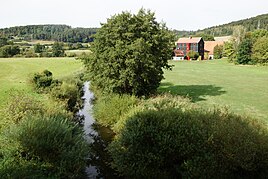
View of the eponymous Petersmühle
|
|
Petermühle was a named part of the municipality of Hausen . With the incorporation on January 1, 1972, the place came to the city of Greding . The hamlet is separated from Hausen by the Federal Highway 9 . As a result, it is located directly in the noise area of the motorway. Ecclesiastically it belongs to the Hausen branch of the parish of Greding. The Kuhbach flows into the Schwarzach directly at the Petermühle .
history
Originally only the Petermill stood here, at last a grain mill. Before the A9 was built in 1935, two farms in Petermühle were relocated to the other side of the Schwarzach. From June 1977 to August 1982 the waterworks of the Jura-Schwarzach-Thalach group was built. In 1993 street names were introduced in Hausen . The street name Schwarzachgrund was assigned to the houses in the former Petermühle district.
Individual evidence
- ↑ Greding - GenWiki. Retrieved April 21, 2018 .
- ↑ Greding Noise Action Plan. Retrieved April 21, 2018 .
- ↑ History | Zweckverband-wasserversorgung.de. Accessed April 21, 2018 (German).
- ↑ Bavaria Atlas of the Bavarian State Government ( notes )

