
Montfaucon JU
| JU is the abbreviation for the canton of Jura in Switzerland and is used to avoid confusion with other entries of the name Montfaucon . |
| Montfaucon | |
|---|---|
 |
|
| State : |
|
| Canton : |
|
| District : | Franches-Montagnes |
| BFS no. : | 6751 |
| Postal code : | 2362 |
| Coordinates : | 570705 / 237011 |
| Height : | 996 m above sea level M. |
| Height range : | 590-1047 m above sea level M. |
| Area : | 18.25 km² |
| Residents: | 603 (December 31, 2018) |
| Population density : | 33 inhabitants per km² |
| Website: | www.montfaucon.ch |
 Montfaucon |
|
| Location of the municipality | |
  |
|
Montfaucon is a municipality in the Franches-Montagnes district in the canton of Jura in Switzerland . The former German name Falkenberg is no longer used today.
On January 1, 2009, the previously independent municipality of Montfavergier merged with Montfaucon.
geography
Montfaucon is 996 m above sea level. M. , five kilometers northeast of the district capital Saignelégier ( linear distance ). The village is located on a panoramic ridge on the Jura plateau of northeastern Freiberge (French Franches-Montagnes ) south from the deep valley of the Doubs .
The area of the 14.8 km² municipal area comprises a section of the gently undulating plateau of the Plateaujura, on which boggy, mostly above-ground drainage-free depressions alternate with limestone peaks . The northern part is taken up by the mountain ridge (up to 1031 m above sea level ) on which Montfaucon is located. To the east of the village is the Plain de Saigne basin , which contains a bog with several bog lakes and merges to the northeast into the catchment area of the Tabeillon brook , albeit without surface watercourses. Extensive Jurassic pastures stretch to the south with large spruce trees standing individually or in groups , crossed by a few forest areas. The highest point of the municipality is northeast of the Bois de la Chaux with 1040 m above sea level. M. achieved. In 1997, 4% of the municipal area was in settlements, 29% in forests and woodlands, 66% in agriculture and a little less than 1% was unproductive land.
Montfaucon includes the hamlet of Pré-Petitjean ( 928 m above sea level ) in the depression south of the village by the train station, as well as numerous individual farms spread across the Jura meadows. Neighboring communities of Montfaucon are Le Bémont , Les Enfers , Soubey , Clos du Doubs , Saint-Brais , Lajoux and Les Genevez in the canton of Jura and Tramelan in the canton of Bern .
population
With 603 inhabitants (as of December 31, 2018), Montfaucon is one of the smaller communities in the canton of Jura. 91.8% of the residents are French-speaking, 7.2% German-speaking and 0.4% Spanish-speaking (as of 2000). The population of Montfaucon was 497 in 1850 and 654 in 1910. In the course of the 20th century, the population decreased to 439 people by 1980. Since then, a slightly increasing trend has been recorded again.
economy
Montfaucon is still a predominantly agricultural village with dairy farming and cattle breeding . There are other jobs in the areas of mechanics and watchmaking. In 1968, a holiday village of the Swiss Travel Fund (Reka) was created near Montfaucon , which helped the Freiberg region to gain significant tourist development. Many workers are also commuters.
traffic
The municipality is located on the main road from Delémont to La Chaux-de-Fonds , on which the bus route from Glovelier to Saignelégier also runs. On May 21, 1904, the railway line of the Régional Saignelégier – Glovelier , a predecessor of the Chemins de fer du Jura, opened with a station in the hamlet of Pré-Petitjean. It is located around 1 km from Montfaucon.
history


The village was first mentioned in 1139 in a document from Pope Innocent II as Mons Falconis . It belonged to the dominion of Freiberge, which was subordinate to the Principality of Basel . From 1793 to 1815 Montfaucon belonged to France and was initially part of the Département du Mont-Terrible , from 1800 it was linked to the Département Haut-Rhin . Due to the decision of the Congress of Vienna , the place came to the canton of Bern in 1815 and on January 1, 1979 to the newly founded canton of Jura. After the voters of Montfaucon on June 11, 2007 and those of Montfavergier on June 12, 2007 approved a merger of the two municipalities, Montfavergier was incorporated into Montfaucon with effect from January 1, 2009.
Attractions
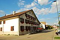
The construction of the parish church of Saint-Jean Baptiste began in 1831 in the neoclassical style , the tower has a Byzantine dome. The first church in the Franches-Montagnes stood in Montfaucon. The whole region up to Les Bois belonged to the mother parish of Montfaucon until the end of the 15th century. With the construction of new churches in the individual villages, the catchment area became noticeably smaller. In Montfaucon as well as in the hamlets there are characteristic farmhouses from the 18th and 19th centuries with whitewashed facades and the typical, sweeping roofs.
photos

Saint-Baptiste parish church
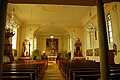
Interior of the church

organ

graveyard

Hotel du Lion d'Or
Hotel de la Pomme d'Or

Pré-Petitjean train station

Doline at Pré-Petitjean


Personalities
- Roger-Émile Aubry CSSR (1923-2010), Episcopal Vicar of Reyes in Bolivia
Web links
- Official website of the municipality of Montfaucon
- Claude Rebetez: Montfaucon. In: Historical Lexicon of Switzerland .
Individual evidence
- ↑ Permanent and non-permanent resident population by year, canton, district, municipality, population type and gender (permanent resident population). In: bfs. admin.ch . Federal Statistical Office (FSO), August 31, 2019, accessed on December 22, 2019 .
La Chaux-des-Breuleux | Lajoux | Le Bémont | Le Noirmont | Les Bois | Les Breuleux | Les Enfers | Les Genevez | Montfaucon | Muriaux | Saignelégier | Saint-Brais | Soubey
Former parishes: Epauvillers | Epiquerez | Goumois | Le Peuchapatte | Les Pommerats | Montfavergier
Canton of Jura | Districts of Switzerland | Municipalities of the Canton of Jura