
Namangan Province
| Namangan viloyati Namangan
|
|
|---|---|
  |
|
| Basic data | |
| Country | Uzbekistan |
| Capital | Namangan |
| surface | 7900 km² |
| Residents | 2,652,400 (January 1, 2017) |
| density | 336 inhabitants per km² |
| ISO 3166-2 | UZ-NG |
Coordinates: 41 ° 0 ' N , 71 ° 12' E
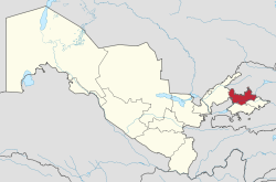
The Namangan Province ( Uzbek : Namangan viloyati ) is located in eastern Uzbekistan , in the southern part of the Ferghana Valley . It has an area of 7,900 square kilometers and a population of 2,652,400 (2017). The population density is 336 inhabitants per square kilometer. The capital is Namangan .
The province was established on March 6, 1941 as part of the Uzbek SSR , but was disbanded between January 5, 1960 and December 18, 1967. Since the collapse of the Soviet Union in 1991, it has belonged to the independent state of Uzbekistan. It is divided into eleven districts (Tuman). The cities of Namangan, Kosonsoy , Uchqoʻrgʻon , Chortoq and Chust are provincial, that is, they do not belong to any district. Kosonsoy, Uchqoʻrgʻon, Chortoq and Chust are also the main towns of the provinces of the same name.
The climate is typically continental with extreme temperature differences between summer and winter. The natural resources include petroleum , natural gas , gold , lead, copper, quartz and antimony . Agricultural products include cotton , horticulture, sericulture, and domestic animal husbandry, including raising angora goats for their valuable hair.
The industry is primarily geared towards the manufacture of textiles, with two large production complexes for silk, as well as non-profit manufacturing facilities for fabrics, cotton yarn, leather and shoes. The area is also a center of traditional Uzbek handicrafts, especially knife making.

|
No. | district | main place | No. | district | main place |
|---|---|---|---|---|---|---|
| 1 | Chortoq | Chortoq | 7th | pop | pop | |
| 2 | Chust | Chust | 8th | To'raqo'rg'on | To'raqo'rg'on | |
| 3 | Kosonsoy | Kosonsoy | 9 | Uchqoʻrgʻon | Uchqoʻrgʻon | |
| 4th | Mingbuloq | Jomashoʻy | 10 | Uychi | Uychi | |
| 5 | Namangan | Toshbuloq | 11 | Yangiqoʻrgʻon | Yangiqoʻrgʻon | |
| 6th | Norin | Haqqulobod | ||||
Individual evidence
- ↑ Uzbekistan: Regions, Major Cities & Towns - Population Statistics in Maps and Charts. Retrieved April 24, 2018 .
- ↑ World Gazetteer: Page no longer available , search in web archives: Uzbekistan - administrative structure (population and area)
Andijon | Buxoro | Fargʻona | Jizzax | Karakalpakistan (Republic) | Namangan | Navoiy | Qashqadaryo | Samarqand | Sirdaryo | Surxondaryo | Tashkent (capital) | Tashkent (province) | Xorazm