
Irgenhausen small fort
| Irgenhausen Castle | |
|---|---|
| Alternative name | unknown |
| limes |
Danube-Iller-Rhein-Limes ( Maxima Sequanorum , backward line) |
| Dating (occupancy) | Valentinian, 4th-5th centuries |
| Type | Street fort |
| unit | unknown |
| size | 60 × 61 m (0.36 ha) |
| Construction | Stone construction |
| State of preservation | completely excavated, conserved and partially reconstructed |
| place | Irgenhausen |
| Geographical location | 702 283 / 246144 |
| height | 562 m above sea level M. |
| Previous | Fort Zurich ( Turicum ) (west) |
| Upstream | Fort Winterthur ( Vitudurum ) (north) |


The small fort Irgenhausen is a Roman fortification in the area of Irgenhausen , an outside watch of the municipality of Pfäffikon in the Swiss canton of Zurich .
The fort previously secured a connecting road that led from Kempraten near Rapperswil-Jona to Oberwinterthur . It was part of the rear line of the late antique Danube-Iller-Rhine-Limes . Its fortifications were built during the final phase of Roman rule over the provinces along the Rhine , Iller and Danube . Built in the 4th century, the fort was probably abandoned at the beginning of the 5th century. The north wall was later used to extract material for the construction of a factory, until the site could be acquired by the antiquarian society in Zurich, which put a stop to the stone robbery. At the end of the 19th century she carried out extensive excavations and restored or partially supplemented the existing wall. Among other things, the hypocaust of a manor ( villa rustica ) from the 1st to 3rd centuries was discovered under the southern corner tower . Today the complex is one of the best-preserved forts in Eastern Switzerland.
Surname
The ancient name of the fort is unknown. The current field name "Bürglen" (or Hagherrenbühel and Schlossberg) is derived from an early medieval castle that is said to have stood there at that time. The place names Irincheshusa and Faffinchova are first mentioned in a document around 811. The document of the 9th century also mentions a place called Camputna / Cambodunum ("Camputuna sive Irincheshusa") . It is assumed that this could have meant the fort.
Location and topography
The region around Irgenhausen belonged to the province of Maxima Sequanorum in late antiquity . The fort is located about 1.5 kilometers south-east of the Pfäffikon parish church on the "Bürglen", a drumlin located about 400 m from the east bank of the Pfäffikersee on the former Roman road that runs from Centum Prata ( Kempraten ) near Rapperswil-Jona Vicus in Vitudurum ( Oberwinterthur ) led. The Bürglen has a height of 566 m and towers over the surrounding terrain by about ten meters, the lake by 25 meters. It drops steeply to the southwest, on the three other sides it gently tapers into the plain. The hill emerged from a glacier moraine, which is mainly composed of diluvial clay with little gravel. Until the beginning of the 20th century he was u. a. used as a vineyard.
function
Research assumes that the fort served to protect the traffic and supply routes to the Roman Rhine border. Other tasks of the crews were probably the monitoring of the road traffic, possibly the interim storage of supplies, the transmission of messages and the blockade of the road in the event of barbarian incursions. A road block could also be accomplished with a small troop, as the lake still covered the entire Irgenhausener Ried at that time.
Research history
Finds of the wall were found in this area early on, but it was assumed at the time that they came from an early medieval castle ruin. In the 18th century, an "upright" human skeleton is said to have been discovered in one of the corner towers. In 1838 Ferdinand Keller recorded the fort's floor plan for the first time. Gerold Meyer von Knonau mentioned in his work "The Canton of Zurich", published in 1844, that according to legend, a Roman fort once stood here, which was destroyed around 1144, but the remains of the wall, which were taller than a man, were still visible for a long time. In addition, while working on the floor, antique coins were repeatedly found, some of which came into the possession of the antiquarian society in Zurich .
In 1856 the landlords, the Vontobel brothers, excavated the western corner tower and uncovered a layer of ash, Roman coins, remains of antlers, broken bricks and allegedly the remains of a floor screed with additions of bricks. In 1857, Ferdinand Keller and four other members of the Antiquarian Society of Zurich carried out an inspection of the corridor, about which a detailed report was then written.
In 1889 members of the Natural History Association Lora, Pfäffikon, exposed the northeast corner tower. In 1892 the owner of the Bürglen, Dietrich, found a 30 to 40 centimeter thick layer of fire during his excavations and stated that the fort walls reached a depth of three meters. In 1897 the fort was to be torn down and the stone material was to be used to build a factory. This was partially implemented with the demolition of the north wall. Further demolition was prevented in 1898 by the Antiquarian Society - under the leadership of Jakob Heierli - which bought the site for 3,000 Swiss francs. In 1897 Jaques Mayor carried out an inventory. His report contains the most precise description of the fort before it was excavated and preserved.
Between 1898 and 1908, the Antiquarian Society, under the direction of Otto Schulthess, carried out further archaeological excavations and investigations on the ruins. The remains were then preserved and partially rebuilt using the original building material. In 1909 it was placed under federal protection as "Fort Irgenhausen" . In 1920, Walter Mittelholzer carried out an early aerial archaeological survey of the fort and its surroundings. Other Roman buildings ( Villae Rusticae ) were located and excavated in the immediate vicinity . In 1957 the fort came into the possession of the municipality of Pfäffikon ZH.
development
After the abandonment of the Upper Germanic-Rhaetian Limes (see also Limesfall and Imperial Crisis of the 3rd Century ) in the 3rd century, the Romans withdrew again to the old border line on the Rhine and Danube. Under the emperors Valentinian I (364–375) and Gratian (367–383), a large-scale fortress construction program on the Upper Danube , the Upper Rhine and Lake Constance was set in motion in a second expansion phase . This new chain of fortresses should make it more difficult for the Germanic tribes, who were constantly pushing in, to invade the territory of the empire. Particularly endangered border sections on the Upper Rhine and between Bregenz and Iller were massively secured in the 4th century with new forts and numerous watchtowers or small fortresses ( burgi ) . They were additionally reinforced by a series of forts at the rear, which were supposed to secure the most important approach and supply routes to the Rhine Limes. One of them was in Irgenhausen. The dating of the fort is uncertain. It is possible that the fort was built at the time of Emperor Diocletian (284–305) around the year 294/295 AD, at the same time as facilities such as Tasgetium . But it could also - like the fort in Schaan - not have been founded until the reign of Valentinian I , around 364 to 375 AD. Together with a few other Limes forts in Syria, Arabia and North Africa, it still belongs to the so-called “Diocletian type” (284–305). A coin find in this regard points to the year 370 AD. The former cannot be proven beyond doubt, as the fort was not on a main Roman traffic route, but apparently only served as a barrier on the connecting road from Vitudurum (Oberwinterthur) to Kempraten on Lake Zurich . On the other hand, it is known that under Valentinian I not only new fortresses were built, but also existing ones were repaired and strengthened. The o. E. Coins found therefore do not necessarily have to mark the beginning of the first construction phase. Soon after AD 400 the fort was evacuated by its crew and then probably destroyed in the course of an Alemanni invasion . Nothing is known about a post-ancient use of the facility.
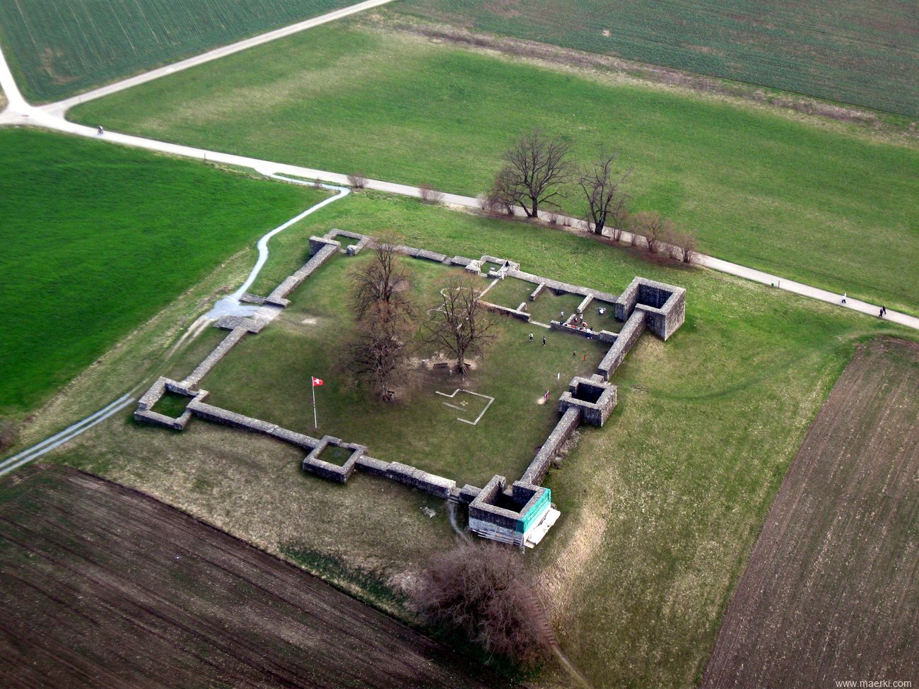
Fort
The fort had a square floor plan, slightly warped on the north and west corners to compensate for the uneven terrain of the hill. The fort wall enclosed an area of 60 × 61 meters side length (0.366 hectares). It was very similar to forts in the Orient, such as the one near Muhatet el Haddsch, on via Traiana , south of the Nabatean city of Petra , the small fort Gasr Bularkan in the hinterland of the Libyan Limes Tripolitanus , that of Schaan in neighboring Liechtenstein, Aying in Bavaria and Bregenz ( Brigantium ) in Austria. The camp was evidently built by several building vexillations with different craftsmanship, as can be seen very clearly from the quality of the masonry. The building material was obtained from glacial deposits. There is also a mixture of Verrucano from the Glarus region , limestones from the Helvetic ceilings and nail fleas . The mortar was white to slightly reddish in color and consisted of sand and lime.
Dimensions in detail:
- North front 61.80 m
- South front 60.80 m
- Western front 61.25 m
- Eastern front 60.60 m
Fort wall
The surrounding wall was about 1.90 m thick, the height is unknown. It was made of uncut field stones (pebbles), with the occasional addition of bricks, using the Opus spicatum technique (herringbone pattern). Its core consisted of mortared rubble stones laid in layers (cast masonry). It was broken through - in addition to the east gate - by three additional gates, 1.5–1.6 m wide. One was located south of the western central tower, the second east of the northern corner tower and the third east of the southern central tower. On all four sides there were also 0.40 × 0.25 m wall slots (one each between the corner and central tower) that narrowed from the inside to the outside. Presumably, they served to drain off rainwater or as ventilation or light donors for the interior structures. Six round, seven-centimeter-wide holes were found on the western front, probably also drains for rain or seepage water.
Towers and gates
The wall was reinforced by four square corner towers, a gate tower on the southeast side and three smaller central towers in the middle of the north, west and south fronts. The side lengths of the corner towers were 8 × 8 m, those of the central towers 6 × 6 m. Its outer walls were 1.40–1.50 m thick, but only 1.10–1.15 m thick on the inside. The corners consisted of larger, square-cut blocks of tuff. All of them had 1.10–1.40 m wide entrances with concrete thresholds on their inside. When North and Westeckturm they were on the curtain wall, the Western Front, the South and Osteckturm on the Eastern Front. On the central towers it was exactly in the middle. The gate of the western corner tower was best preserved.
Interior development
In addition to the remains of the corner towers and the surrounding wall, there were also remains of the stone interior structures. A three-room building was interpreted as a bathing facility (fort thermal baths). In addition to another building with three rooms, which was interpreted as a principia (staff building), the hypocaust complex of an extensive villa rustica from the 1st to 3rd centuries was found under the southern corner tower , which was destroyed before or during the construction of the fort was. It probably covered the whole plateau and the terrain up to the base of the hill. Your living quarters are likely to have been concentrated on the north and south corners. The functional buildings of the fort were probably made entirely of wood and could therefore no longer be clearly identified. Presumably they comprised some team barracks, a horreum (granary) and a praetorium (commandant's residence).
The walls of two rooms with semicircular apses probably belong to an early medieval church, the Benignus Church of Pfäffikon, which was built over the ruins of the late antique fort.
garrison
The troops of the province of Maxima Sequanorum were in late antiquity under the command of a Dux provinciae Sequanicae . Which department of the Roman army provided the garrison of the fort is unknown due to the lack of relevant inscriptions. Due to its small size, not even a number could be accommodated here. With such a small crew, it could not withstand a long siege either.
Monument protection, preservation of findings and what is found
The fort area is a historical site within the meaning of the Swiss Federal Law on Nature Conservation and Heritage Protection of July 1, 1966, and is subject to federal protection. Unauthorized investigations and targeted collection of finds constitute a criminal act and are punishable by imprisonment of up to one year or a fine according to Art. 24.
For the restoration of the walls of the Irgenhausen Fort by the Antiquarian Society Pfäffikon, the original Roman building material was used again and the fort was then made accessible to the public. The Pfäffikon municipality has taken over the nursing activities since the system was sold. It can be visited all year round and is provided with information boards. The fort can be reached on three well-marked paths. Arrival by public transport: from Zurich main station with the S3 to Pfäffikon ZH and on with the Postbus routes 835 or 837 to Irgenhausen.
Finds from the fort excavation and adjacent manors are housed in the Museum am Pfäffikersee Pfäffikon and the Wetzikon Local History Museum.
gallery

View from Seegräben over the Pfäffikersee to the fort

View from the northwest

View from the south

View from the east

View from the north

Coin of valens

Mantle fibula from the 4th century


_IMG_3436.JPG)


.png)
.png)
See also
List of forts in the Danube-Iller-Rhein-Limes
literature
- Otto Schulthess: The Roman fort Irgenhausen (Canton Zurich). In: Mitteilungen der Antiquarian Gesellschaft in Zürich 27, 1911, pp. 41–114.
- Wilhelm Unverzagt Individual finds from the late Roman fort near Irgenhausen (Canton of Zurich) . In: Anzeiger für schweizerische Altertumskunde NF 18, 1916, pp. 257–268.
- Ernst Meyer : The Roman fort Irgenhausen . Archaeological Guide of Switzerland, Issue 2. Swiss Society for Prehistory, Basel 1969.
- Antiquarian Society (Hrsg.): Time travel: Irgenhausen. Archaeological discoveries around the Roman fort Pfäffikon Irgenhausen: from the Neolithic to the excavations a hundred years ago . Zürcher Oberland Buchverlag, Wetzikon 1999. ISBN 3-85981-196-7 (CD-ROM).
Web links
- Andreas Zürcher: Irgenhausen. In: Historical Lexicon of Switzerland .
- Exhibition of found objects: Museum am Pfäffikersee, Pfäffikon
- Aerial view of the castle ruins
Remarks
- ↑ Otto Schultheiss 1911, p. 109
- ↑ Otto Schultheiss 1911, p. 44
- ↑ Otto Schultheiss 1911, p. 105
- ↑ Otto Schulthess 1911, pp. 94–96, 103–107
- ↑ Otto Schulthess 1911, pp. 54–55, 94–97
- ↑ Otto Schulthess 1911, pp. 94–95
- ↑ Otto Schultheiss 1911, p. 105
- ↑ Swiss Federal Law on Nature Conservation and Heritage Protection 1966 (PDF; 169 kB).
- ^ Homepage Museum am Pfäffikersee of the Antiquarian Society Pfäffikon
Sasbach-Jechtingen Castle (Sponeck Castle) | Fort Breisach (Mons Brisiacus) | Fort Oedenburg-Bisheim (Argentovaria) | Horbourg Castle | Mandeure Castle (Epomanduodurum) | Ilzach Castle (Uruncis) | Kembs Castle (Cambes) | Castle Basel-Münsterhügel (Basilia) | Kaiseraugst Castle (Castrum Rauracense) | Small fort Frick-Kirchhügel (Ferraricia) | Zurzach Castle (Tenedo) | Fort Kirchlibuck-Sidelen | Winterthur Castle (Vitudurum) | Eschenz Castle (Tasgetium) | Pfyn Fort (Ad fines) | Baden Castle (Aquae Helveticae) | Castrum Vindonissense | Burgus Schlatt-Schaarenwiese | Altenburg Castle | Fort Olten | Fort Solothurn | Studen Castle | Avenches Castle | Yverdon Castle (Eburodunum) | Kloten Castle | Zurich Castle ( Turicum ) | Weesen Castle | Pfäffikon-Irgenhausen small fort