
Ringwall old castle
| Ringwall old castle | ||
|---|---|---|
 Ringwall old castle |
||
| Alternative name (s): | Old Castle, Old Castle, Rudolf Castle | |
| Creation time : | probably 8th to 10th century | |
| Castle type : | Niederungsburg | |
| Conservation status: | ruin | |
| Place: | Aarbergen - Panrod | |
| Geographical location | 50 ° 16 '26.5 " N , 8 ° 7' 52.7" E | |
| Height: | 310 m above sea level NHN | |
|
||

The Ringwall Altschloss is located in the northeastern part of the municipality of Aarbergen approx. 1.5 km north of the Panrod district and approx. 1.0 km northwest of Hünstetten - Ketternschwalbach im Rudolfswald im Hintertaunus . The Seelbach rises in the immediate vicinity.
Historical classification
In terms of its facilities, the ring wall old castle can probably be classified in the 8th to 10th centuries. However, details are not known, there are no documentary mentions. There are two theories about the importance of the system.
One assumption is that it served as a refuge for the inhabitants of the presumed deserted Nieder- and Oberseelbach . Numerous field borders in the area indicate this.
The second theory says that the complex was owned by a knight Rudolf, who was also the namesake for the Rudolfswald. This is also unproven. No facts are known to substantiate any of the theories factually.
investment
The facility is almost circular with a diameter of the inner wall of approx. 35 m. Access is now guaranteed from the north via a small wooden bridge that spans the moat . The moat completely encompasses the facility. The remains of the outer wall are also clearly visible to the west. Compared to the surrounding forest floor, the wall is about 1.0 m to 2.5 m high and 7 m to 11 m wide. The moat, fed by two inlets, has a width of approx. 3.0 m. In the northeast there is a 50 meter long outer wall.
In the depiction of Karl August von Cohausen (1812-1894) remains of fire rubble such as oak charcoal and bricked clay were found. These finds indicate that a wood-earth fortification burned down here.

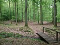
Access via wooden bridge
Overview of the entire system

Water outlet from ramparts


Tourist development
The facility is integrated into the Palmbachtal nature trail and has a display board. The cultural monument is incorrectly referred to there as a “ natural monument ”.
Monument protection
The area of the ramparts is a ground monument according to the Hessian Monument Protection Act . Investigations and targeted collection of finds are subject to approval, and accidental finds are reported to the monument authorities.
swell
- Christian Stolz (2013): Archaeological indicator plants: case studies from the Taunus and northern Schleswig-Holstein. Plants as indicators for archaeological find sites: Case studies from the Taunus Mts. and from the northern part of Schleswig-Holstein (Germany) . - Writings of the Regional and Folklore Working Group 11: 1–30 [1]
- Topographic map 1: 25,000 5714 Kettenbach, Hessian State Office for Soil Management and Geoinformation
Web links
- Entry on the ring wall old castle in the scientific database " EBIDAT " of the European Castle Institute
- Information from Burg Direkt
- Information on the homepage of the municipality of Aarbergen
Individual evidence
- ↑ Christian Stolz (2013): Archaeological pointer plants: case studies from the Taunus and northern Schleswig-Holstein. Plants as indicators for archaeological find sites: Case studies from the Taunus Mts. and from the northern part of Schleswig-Holstein (Germany) . - Writings of the Regional and Folklore Working Group 11: 1–30

Adolfseck Castle | Schanze Adolfseck | Old Schanz | Old lock | Ringwall Altenstein | Ringwall old castle | Fortress Blideneck | Boosenburg | Brömserburg | Brömserhof | Crass Castle | Ringwall Dreibornskopf | Ehrenfels Castle | City Castle Eltville | Geroldstein Castle | Glimendal Castle | Greifenstein Castle | Ringwall Hallgarter Pliers | Haneck Castle | Hareschloß | Hattenheim Castle | Hohenbuchau Castle | Hohenstein Castle | Holdersberg Castle | Idstein Castle | Johannisberg Castle | Johannisberg Castle | Kammerburg | Lauksburg | Ring wall system Nack | Neuhaus Castle (Eltville) | Burgstall Neuhof (Taunusstein) | Niederwald Hunting Lodge | Nollig ruins | Palais Ostein Geisenheim | Plixholz ruin | Reichartshausen Palace | Reinhartshausen Castle | Rheinberg Castle | Rotenburger Schlösschen | Scharfenstein Castle | Schönborn Palace | Schwarzenstein Castle | Tower Castle Walluf | Vollrads Castle | Vorderburg (Rüdesheim) | Waldeck Castle | Waldems ring wall | Wallrabenstein Castle | Wehen Castle