
Plixholz ruin
| Plixholz ruin | ||
|---|---|---|
 Remains of the draw well on the ruins |
||
| Alternative name (s): | Plexwood, Blixholz | |
| Creation time : | 14th Century | |
| Castle type : | Niederungsburg | |
| Conservation status: | ruin | |
| Standing position : | unknown | |
| Place: | Rudesheim - Windeck | |
| Geographical location | 50 ° 0 '33.8 " N , 7 ° 55' 40.3" E | |
|
||

The ruins of Plixholz , also called Plexholz, are the ruins of a permanent house in the mountains of the Rheingau , about 1500 meters north of Rüdesheim -Windeck. The site belongs to the district of Geisenheim in the Rheingau-Taunus district . This permanent house was originally built by the Brömser family . Today the Plixholz area is owned by the Diocese of Limburg .
Location and description
The Plixholz ruin is located directly on the Weibspfad , a medieval road, in a small wooded area. The Nothgottes Monastery is 600 meters south . The facility is surrounded by agricultural land.
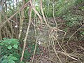
The ruin itself is essentially reflected in the form of deformations of the terrain. The area is completely overgrown. In the eastern area of the complex there are still remains of the wall and the remains of a draw well. There is also a vault on site, which was walled up and locked.
Originally there was a wide wall ring with two round towers on the south side. There were four houses within this fence. The field area comprised around 11 hectares of fields, meadows and small wooded areas.
history
The area around Plixholz can be assigned to the Brömser family . Against the background of the cultivation of the southern slopes in the Rheingau with grapevines, clearing was carried out in the wooded mountains of the Rheingau with the aim of making agriculture possible and cattle breeding. Plixholz can also be traced back to such clearing, although archival documents on the exact time of origin are missing. It can be assumed that the clearing was carried out around 1100 AD. The name Plixholz (sometimes also spelled Plexholz or Blixholz ) may also be traced back to the clearing, if a derivation from the Old High German plecchen (for lightning but also to expose or make visible ) is assumed.
Around 1390 a chapel was built by the Brömser in the Nothgotteser valley , almost at the same time as the parish church in nearby Rüdesheim am Rhein. The Rüdesheim city archivist Rolf Göttert concludes from this that Plixholz already served as a residence for courtiers and was already designed as "Vestes House" here .
Plixholz was first mentioned in 1562 on a Brömser document. The foundation deed of the Nothgottes monastery was signed in 1621 on plix wood. Plixwood was also made available to the monks of the Capuchin Order for the purpose of supply. However, Plixholz fell back to the Brömser family in 1666. The reasons for this are unknown, but it can be assumed that, due to the Thirty Years' War and the plague, too few workers were available for the operation.
In 1668 the line of the Brömser died out, so that Plixholz fell to the Baron von Metternich . A group of Calvinists lived here from 1675 to 1760 . In 1740 the Rüdesheim surveyor Andreas Trauttner made a map on the basis of which the system can be reconstructed today. The Metternichs sold to the Baron von Zwierlein in 1812 . In 1813 the Zwierleins also bought the Nothgottes monastery, which was secularized under Napoleon and which had been abandoned in 1813. They sold a large part of the remaining church equipment (such as the stained glass windows), but otherwise left the monastery and Plixholz to decay. As early as the first half of the 19th century, Plixholz was no longer habitable.
The purchase of Nothgottes and Plixholz by lawyer widow Emma Frohn in 1903 changed the situation. She had the monastery buildings restored by Nothgottes and an agricultural business set up at the monastery to replace Plixholz. During this time, the Rüdesheim architect Müller also recorded the remains of the masonry in a plan. As a result of the crisis years, the properties fell to the Diocese of Limburg in 1932 .
In 1950 the last remains of the surrounding wall were leveled for use as arable land.
It is known that clay was quarried in the hallway of the Plixholz . As a result of this mining, the earth collapsed in an open field in a hole 2 meters in diameter. At a depth of three meters it widened in a bell shape and the remains of the wooden structure were found.
gallery

Walled access to the vault

Cellar vault
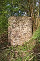
Remnants of the tower-shaped draw well
Remains of the masonry

Grove on the Plixholz ruins


Web links
- Rolf Göttert: Plixholz and its secrets. In: Notes from the city archive. 89, Rüdesheim 1998.
Individual evidence
- ↑ Eberhard Kümmerle: Suddenly holes form. ( Page no longer available , search in web archives ) Info: The link was automatically marked as defective. Please check the link according to the instructions and then remove this notice. In: Wiesbadener Tagblatt . May 10, 2011.

Adolfseck Castle | Schanze Adolfseck | Old Schanz | Old lock | Ringwall Altenstein | Ringwall old castle | Fortress Blideneck | Boosenburg | Brömserburg | Brömserhof | Crass Castle | Ringwall Dreibornskopf | Ehrenfels Castle | City Castle Eltville | Geroldstein Castle | Glimendal Castle | Greifenstein Castle | Ringwall Hallgarter Pliers | Haneck Castle | Hareschloß | Hattenheim Castle | Hohenbuchau Castle | Hohenstein Castle | Holdersberg Castle | Idstein Castle | Johannisberg Castle | Johannisberg Castle | Kammerburg | Lauksburg | Ring wall system Nack | Neuhaus Castle (Eltville) | Burgstall Neuhof (Taunusstein) | Niederwald Hunting Lodge | Nollig ruins | Palais Ostein Geisenheim | Plixholz ruin | Reichartshausen Palace | Reinhartshausen Castle | Rheinberg Castle | Rotenburger Schlösschen | Scharfenstein Castle | Schönborn Palace | Schwarzenstein Castle | Tower Castle Walluf | Vollrads Castle | Vorderburg (Rüdesheim) | Waldeck Castle | Waldems ring wall | Wallrabenstein Castle | Wehen Castle