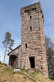
Rinkenturm
|
Rinkenturm
|
||
|---|---|---|
| Basic data | ||
| Place: | Rinkenkopf mountain near Baiersbronn | |
| Country: | Baden-Württemberg | |
| Country: | Germany | |
| Altitude : | 724 m above sea level NN | |
| Coordinates: 48 ° 30 '54.2 " N , 8 ° 21' 55.7" E | ||
| Use: | Observation tower , radio transmitter | |
| Accessibility: | Transmission tower open to the public | |
| Tower data | ||
| Data on the transmission system | ||
| Waveband : | FM transmitter | |
| Radio : | VHF broadcasting | |
| Position map | ||
|
|
||
The Rinkenturm (formerly King Wilhelms-Turm ) is a lookout tower at 759.6 m above sea level. NHN high Rinkenkopf above the Murg valley near Baiersbronn in the northern Black Forest . From here there is a view of the Murgtal, in particular the towns of Klosterreichenbach and Baiersbronn.
The Rinkenturm was built in 1914 by the Württemberg Black Forest Association from red sandstone and named after the then Württemberg King Wilhelm II . In 1982 the municipality of Baiersbronn acquired the Rinkenturm from the Black Forest Association.
The Rinkenturm was also used for radio. In addition to the non-public BOS radio, there was a filling transmitter for Das Erste on the Rinkenturm. In 1970, the Federal Post Office erected a 65.8-meter-high precast concrete tower in the immediate vicinity of the Rinkenturm to broadcast the ZDF and the third program, which is still used today as a filling station for VHF radio in order to close gaps in reception in the Murgtal around Baiersbronn.
In 2007 this tower was followed by a steel lattice tower from Vodafone D2. The latter was originally 46.08 meters high and was increased to 55 meters in 2010 by adding an antenna for the digital BOS radio.
Frequencies and Programs
Analog radio (VHF)
|
Frequency (MHz) |
program | RDS PS | RDS PI | Regionalization |
ERP (kW) |
Antenna pattern round (ND) / directional (D) |
Polarization horizontal (H) / vertical (V) |
|---|---|---|---|---|---|---|---|
| 87.9 | SWR4 Baden-Württemberg | SWR4_FR_ | DB04 | South Baden | 0.1 | ND | H |
| 104.1 | Free Radio Freudenstadt | FDS104.1 | 150E | - | 0.1 | ND | H |
The frequencies 96.8 MHz and 99.2 MHz are also planned here to improve SWR reception in the region. However, it is unknown whether and when the frequencies will go into operation.
Digital radio (DAB)
| block | Programs (data services) |
ERP (kW) |
Antenna diagram round (ND), directional (D) |
Polarization horizontal (H) / vertical (V) |
Single frequency network (SFN) |
|---|---|---|---|---|---|
| 8D SWR BW S (D__00235) |
DAB + block of the SWR
|
Bad Urach , Baiersbronn , Blauen , Brandenkopf , Eggberg (Bad Säckingen) , Feldberg in the Black Forest , Freiburg (Schönberg) , Hornisgrinde , Raichberg , Schramberg , Schutterlindenberg , Sigmaringen , Ulm / Kuhberg , Villingen-Schwenningen , Wannerberg , Witthoh
|
Analog television (PAL)
Before the switch to DVB-T, the transmitter location was also used for analog television:
| channel |
Frequency (MHz) |
program |
ERP (kW) |
Transmission diagram round (ND) / directional (D) |
Polarization horizontal (H) / vertical (V) |
|---|---|---|---|---|---|
| 5 | 175.25 | The First (SWR) | 0.0003 | D. | H |
| 25th | 503.25 | ZDF | 0.1 | D. | H |
| 60 | 783.25 | SWR television Baden-Württemberg | 0.1 | D. | H |
See also
Web links
Individual evidence
- ↑ Map services of the Federal Agency for Nature Conservation ( information )
- ↑ View from the Rinkenturm near Baiersbronn in schwarzwaldnatur.blogspot.de from November 13, 2009, accessed on January 5, 2015
- ↑ Baiersbronn municipality 1969–1990


