Schutterlindenberg
| Schutterlindenberg | ||
|---|---|---|
|
Lindenhain and transmitter on the Schutterlindenberg |
||
| height | 297 m above sea level NHN | |
| location |
Ortenaukreis , Baden-Württemberg , Germany |
|
| Mountains | Black Forest | |
| Coordinates | 48 ° 20 '55 " N , 7 ° 51' 24" E | |
|
|
||
The Schutterlindenberg is 296.5 m above sea level. NHN high, on the northern edge of Lahr , extension of the foothills of the Black Forest .
Surname
It got its name from the Schutter , a right-hand tributary of the Rhine that rises in the Black Forest and overlooks the valley at Lahr by around 150 m. In addition, the part of the name -linden- refers to the extensive linden grove which is located on its summit and which is visible from afar, as the foothills near Lahr are otherwise free of forests.
particularities
outlook
The Schutterlindenberg offers a panorama that extends from the heights of the Black Forest over the lowlands of the Upper Rhine Plain to the peaks of the Vosges . The city of Lahr and the surrounding villages can be seen in the vicinity. In the far range, the view extends to the Belchen , one of the highest mountains in the Black Forest, to the west to the highest mountain in the Vosges, the Grand Ballon d'Alsace or Great Belchen, and to the northwest to Strasbourg , one of the largest cities in France with the Strasbourg Cathedral .
Constitutional pillar
To commemorate the 1st Baden constitution of 1818 , a column was erected on the Schutterlindenberg on August 22, 1843 in honor of the 25th anniversary of the city of Lahr. This was inaugurated with a constitutional ceremony. The constitution, which was honored with the pillar and approved by Karl Ludwig Friedrich (Baden) , Grand Duke of Baden, grants a parliamentary assembly in Baden the right to participate in legislative procedures and in the setting of taxes. The column was damaged by American artillery fire in 1945 and was re-erected in 1962 by the city of Lahr. The restoration by the Rotary Club took place on the occasion of the 150th anniversary of the Baden Revolution of 1848.
Schubert monument
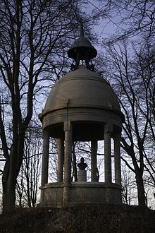
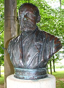
On the summit of the Schutterlindenberg there is also a memorial stone and a pavilion with the bust of the Lahr merchant, mayor, President of the Chamber of Commerce and Member of Parliament Wilhelm Schubert (1813-1893). He is honored with the stone as follows: “The brave, truly liberal friend of the people, the patron of everything good, true, noble and beautiful.” Schubert is one of the most important republicans in his city in the Vormärz and during the revolution of 1848/49.
Transmission tower
On the Schutterlindenberg there is a transmission tower made of reinforced concrete. This transmission tower supplies the southern Ortenau and northern Breisgau with VHF and DAB radio programs.
Analog radio ( VHF )
|
Frequency (MHz) |
program | RDS-PS | RDS-PI | Regionalization |
ERP (kW) |
Antenna pattern round (ND) / directional (D) |
Polarization horizontal (H) / vertical (V) |
|---|---|---|---|---|---|---|---|
| 107.4 | Hitradio ear | HITRADIO / _O_H_R__ | D40D | - | 5 | H |
Digital radio ( DAB + )
Landscape protection area
The Schutterlindenberg and its surroundings are designated as a landscape protection area (protected area number 3.17.009) by ordinance of the former Lahr district office of August 24, 1966 . The area has a size of 362.0 hectares.
Others
- The Schutterlindenberg is a traditional fairground in the city of Lahr. There were celebrations there, for example on the occasion of the 100th birthday of Friedrich Schiller on November 10, 1859 and on the occasion of the 50th anniversary of the Battle of the Nations near Leipzig on October 18, 1863.
- An ecumenical service is celebrated on the mountain on Whit Monday.
- The Schutterlindenberg is an old Lahr winegrowing location . The large site is about 60 hectares and extends from the Schutterlindenberg north to Friesenheim . It is divided into the individual layers Herrentisch above Lahr and Kronbühl in the north. Above all, Pinot Blanc is grown.
- The Schutterlindenberg School in Lahr is named after the mountain.
- There is a stone bench on the mountain that once had its place on the Dinglingen toll bridge, which was destroyed in 1945.


