Emmerlev Sogn
| Emmerlev | ||||
|
||||
| Basic data | ||||
|---|---|---|---|---|
| State : |
|
|||
| Region : | Syddanmark | |||
|
Municipality (since 2007) : |
Tønder | |||
| Municipality / Office : (until the end of 2006) |
Højer Kommune Sønderjyllands Amt |
|||
|
Harde / Amt: (until March 1970) |
Tønder, Højer og Lø Herred Tønder Amt |
|||
| Coordinates : | 54 ° 59 ′ N , 8 ° 40 ′ E | |||
|
Population : (2020) |
510 | |||
| Area : | 33.4 km² | |||
| Population density : | 15 inhabitants per km² | |||
| Postal code : | 6280 Emmerlev | |||
| Website: | www.emmerlevogvisby.dk | |||
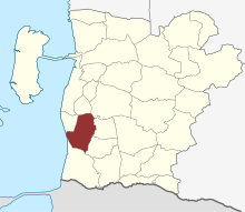
 Location of the parish |
||||
Emmerlev Sogn ( German : Municipality Emmerleff ) is a parish municipality ( Danish Sogn ) in the region of Syddanmark , Denmark . It belonged to Harde Tønder, Højer og Lø Herred in what was then Tønder Amt until 1970 , then to Højer Kommune in what was then Sønderjyllands Amt , which was merged into the "new" Tønder Kommune in the Syddanmark region as part of the municipal reform on January 1, 2007 .
Municipal area
The municipality covers about 33.4 km². The population is now 510 (January 1, 2020), while in 1860 it was still over 1500.
In the west the area borders on the North Sea and Hjerpsted Sogn , in the north on Skast Sogn and Brede Sogn , in the east on Visby Sogn and Daler Sogn and in the south on Højer Sogn .
history
Traces of human settlement have been found since the Bronze Age .
In the Middle Ages, Emmerlev belonged to the Højer-Harde. Large parts of the community were soon separated from the joint association. Both the bishop of Ribe and the cathedral chapter there acquired some land. In addition, Kuxbüll and Südergaarde developed into aristocratic estates . These were bought by the Duke in 1649, their grit remained an independent municipality until 1864.
The possessions of the bishop and the cathedral chapter belonged to the Kingdom of Denmark , as the bishop was a Danish imperial prelate. The rest of the parish belonged to the Duchy of Schleswig . When the country was divided in 1544 it went to Johann the Elder , after his death in 1581 to the Dukes of Gottorf , where it remained until King Friedrich IV confiscated Schleswig-Gottorf in 1713 and formally in 1721. Emmerlev belonged to the Ribener estates, which came to the county of Schackenburg (see Møgeltønder ) in 1661 , to the Amt Tønder.
In 1864 the parish was administratively unified and after the municipal reform of 1869 it was divided into the four rural communities Norder-Seiersleff (with Wester-Gammelby), Süder-Seiersleff (with the church), Kjärgaard and Emmerleff. Initially the Hardesvogtei Wiesby was the lower police authority, but from 1889 it was an administrative district of Emmerleff, to which Jerpstedt belonged. The office of Tønder was redesigned with all previous enclaves in 1869 to form a unified district of Tønder .
In the referendum on state membership on February 10, 1920, 563 residents voted for Denmark and 89 for Germany. Four months later, North Schleswig was united with Denmark. From then on, Emmerlev formed a unified parish commune. The proximity to the new border and the remote transport connections prevented a new upswing, and the population continued to decline. In 1970 Emmerlev became part of the large municipality of Højer Sogn, which in turn became part of the enlarged municipality of Tønder in 2007.
Economy and Transport
Emmerlev is located directly on the North Sea, but there are no harbors here. The next railway connection is to the east in Visby . In Wester-Gammelby, the roads from Højer to the north cross and the connection from Ballum and Hjerpsted to the green coastal road A 11.
Economically, the area is characterized by agriculture and tourism, numerous residents commute to the larger neighboring towns. Since 2005 there have been plans for a huge North Zealand wellness center on the municipality's coast.
Attractions
At Emmerlev there is one of the very few cliffs on the eastern North Sea, the Emmerleffer Kliff ( Emmerlev Klev ) with a maximum height of at least 13 meters. This area is home to one of the best beaches on the Schleswig mainland. To the south of the cliff there is a dike that can be walked to Højer. The view of the island of Sylt and the Hindenburg dam is remarkable .
A well-known building in the municipality is the Højkro inn . The one with thatch roofed brick building from the 18th century is one of the best preserved historic inns in Denmark. With the resulting travel barn, a small acceptance Kate on the road, the high Linden and the otherwise deserted situs close to the Church of the pitcher is a particularly evocative historic ensemble.
Also worth seeing is the Romanesque church, one of the longest in the area. The compact tower with the Törninglehn peak and the choir are made of bricks, but the nave is made of granite blocks , supplemented with Rhenish tuff , which was often used in the south of the diocese of Ribe because boatmen from the then important cathedral city used tuff as ballast in the Middle Ages their return trips. Special pieces of equipment are the baptismal font from Romanesque times and the late Gothic winged altar.
Personalities
- Niels Nikolaus Falck (1784–1850), lawyer, historian and politician
Web links
- Website of the municipality (Danish)
- Entry in the Sogneportalen (Danish)
- Information about Danish parishes and municipalities
- Website of the municipality of Tønder


