San Jacinto (Pangasinan)
| Municipality of San Jacinto | ||
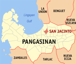
| Location of San Jacinto in the Pangasinan Province | ||
|---|---|---|

|
||
| Basic data | ||
| Region : | Ilocos region | |
| Province : | Pangasinan | |
| Barangays : | 19th | |
| District: | 4. District of Pangasinan | |
| PSGC : | 015534000 | |
| Income class : | 3rd income bracket | |
| Households : | 6143 May 1, 2000 census
|
|
| Population : | 40,848 August 1, 2015 census
|
|
| Population density : | 1294 inhabitants per km² | |
| Area : | 31.56 km² | |
| Coordinates : | 16 ° 4 ′ N , 120 ° 26 ′ E | |
| Postal code : | 2431 | |
| Mayor : | Rolando E. Columbres | |
| Geographical location in the Philippines | ||
|
|
||
San Jacinto is a municipality in the Philippine province of Pangasinan . In 2015, 40,848 people lived in the 31.56 km² area, resulting in a population density of 1294 inhabitants per km². San Jacinto was founded in 1601. Here too, agriculture plays the most important economic role. In addition to grain, a lot of tobacco is grown.
San Jacinto is divided into the following 19 barangays :
|
|
Web links
Commons : San Jacinto, Pangasinan - collection of images, videos and audio files
