Sankt Peders Sogn (Slagelse municipality)
| Saint Peders | ||||
|
||||
| Basic data | ||||
|---|---|---|---|---|
| State : |
|
|||
| Region : | Sjælland | |||
|
Municipality (since 2007) : |
Slagelse | |||
| Coordinates : | 55 ° 24 ' N , 11 ° 21' E | |||
|
Population : (2020) |
10.097 | |||
| Postal code : | 4200 Slagelse | |||
| Website: | www.sctpederskirke.dk | |||
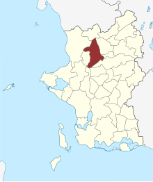
 Location of Sankt Peders Sogn in the Slagelse municipality |
||||
Sankt Peders Sogn is a parish municipality ( Danish : Sogn ) on the Danish island of Zealand . Until 1970 it belonged to Harde Slagelse Herred in what was then Sorø Amt , then to Slagelse Municipality , which in turn was merged into the enlarged Slagelse Municipality as part of the Sjælland region as part of the municipal reform on January 1, 2007 .
On January 1, 2020, of the 34,015 inhabitants of the town of Slagelse, 10,097 were living in the parish. The “Sankt Peders Kirke” and the “Helligåndskirken” are on the territory of the municipality.
Neighboring communities are Havrebjerg Sogn in the north, Nørrevang Sogn in the north-east, Sankt Mikkels Sogn in the east, Antvorskov Sogn in the south-east, Slots Bjergby Sogn and Hemmeshøj Sogn in the south, Hejninge Sogn in the west and Kirke Stillinge Sogn in the north-west .
Individual evidence
- ↑ a b Statistics Banks -> Befolkning og valg -> KM1: Befolkningen January 1st, April 1st, July 1st and October 1st, so og folkekirkemedlemsskab (Danish)
- ↑ Statistics banks -> Befolkning og valg -> BY1: Folketal January 1st efter byområde, alder og køn (Danish)


