Black rain (river)
| Black Rain | ||
|
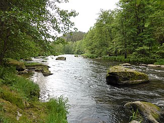
The black rain near Viechtach |
||
| Data | ||
| Water code | EN : 1522 | |
| location | District of Regen , County Cham (Bayern) | |
| River system | Danube | |
| Drain over | Rain → Danube → Black Sea | |
| Beginning as black rain | Confluence of large and small rain in Zwiesel 49 ° 0 ′ 47 ″ N , 13 ° 13 ′ 39 ″ E |
|
| Source height | 553 m above sea level NN | |
| confluence | near Pulling (municipality Blaibach ) with the white rain to the rain coordinates: 49 ° 0 '47 " N , 13 ° 13' 39" E 49 ° 0 '47 " N , 13 ° 13' 39" E |
|
| Mouth height | 381 m above sea level NHN | |
| Height difference | 172 m | |
| Bottom slope | 2.9 ‰ | |
| length | 60.1 km from the confluence |
|
| Catchment area | 995.72 km² | |
| Discharge at the Sägmühle A Eo gauge : 839 km² Location: 123.4 km above the mouth |
NNQ (08/12/1987) MNQ 1976-2006 MQ 1976-2006 Mq 1976-2006 MHQ 1976-2006 HHQ (13.08.2002) |
4.35 m³ / s 6.57 m³ / s 19.3 m³ / s 23 l / (s km²) 212 m³ / s 470 m³ / s |
| Discharge at the confluence with the White Rain A Eo : 995.72 km² |
MQ Mq |
20.7 m³ / s 20.8 l / (s km²) |
| Left tributaries | Rinchnacher Ohe , Schlossauer Ohe , Teisnach , Aitnach | |
| Reservoirs flowed through | Regener See , Höllensteinsee , Blaibacher See | |
| Small towns | Zwiesel , Regen , Viechtach | |
|
Black rain between Böbrach-Öd and Teisnach |
||
The Schwarze Regen is the left and southeastern source river of the Regen in the districts of Regen ( Lower Bavaria ) and Cham ( Upper Palatinate ) in Bavaria . It is created in Zwiesel by the confluence of large and small rain and is hydrologically (because of its size) and hydrographically (because of its length) regarded as the main strand and only a secondary name of the entire Regen river .
geography
course
After the confluence of its source rivers, the Schwarze Regen flows towards the southwest and through the Regener See before the district town of Regen . Then it bends to the northwest and runs as far as Viechtach through a remote landscape that is often referred to as "Bavarian Canada" due to its appearance. The two whitewater sections Bärenloch and Altriegel ( Gumpenrieder Schwall ), which are very popular with canoeists, are located here. Experience and whitewater equipment are required for the two sections, in which some have already died, while life jackets and helmets are compulsory in the bear hole.
After a section of run through unpopulated area, it flows through Teisnach , where the river of the same name flows into the Black Rain. The Teisnach paper factory , which the river supplies with water for the paper, is located in the village . Further down to Viechtach, the Schwarze Regen runs through two reservoirs . It first flows through the Höllensteinsee , then passes the administrative district border from Lower Bavaria to the Upper Palatinate and then runs through the Blaibacher See . Below it, between Bad Kötzting and Blaibach , it unites as a longer (altogether 84 km) and more water-rich (20.7 m³ / s) spring river with the White Rain (38 km, 4.5 m³ / s) to rain .
Tributaries
- Michelsbach (right, near Langdorf - Reisachmühle )
- Tausendbach (left, near Zwiesel- Zwieselberg )
- Schwarzach (left, near Langdorf - Froschau )
- Höllgraben (left, when it rains - Bettmannsäge )
- Rinchnacher Ohe (left, near Regen- Rinchnachmündt )
- Krampersbach (right, rain)
- Steinzenbach (left, rain)
- Schlossauer Ohe , (left, Regen- Oleumhütte )
- Mühlbach (left, Regen-Oleumhütte)
- Galgenbach (right, near Regen- Wickersdorf )
- Schwemmbach (left, near Regen- Sallnitz )
- Salitzerbach (left, near Teisnach - Sohl )
- Steffelbach (right, near Böbrach - Oberauerkiel )
- Auerkielbach (right, near Böbrach- Unterauerkiel )
- Rothbach (right, near Böbrach- Haidsberg )
- Teisnach (left, near Teisnach )
- Asbach (right, near Drachselsried - Bühlhof )
- Gumbach (right, near Viechtach - Rittmannsberg )
- Wiesingerbach (right, Viechtach- Sägmühle )
- Aitnach (left, near Viechtach- Schnitzmühle )
- Riedbach (left, near Viechtach- Rugenmühle )
- Eberbach (right, near Viechtach- Pirka )
- Lammerbach (right, after Pirka in the section through the Höllensteinsee )
- Prackenbach (left, at Prackenbach - Ehrenhof ) in the section through the Höllensteinsee
- Höllensteiner Bach (right, near Viechtach- Höllenstein ) in the section through the Höllensteinsee
- Augraben (right, just after the Höllensteinsee)
- Krailinger Bach (left, near Prackenbach- Ahrain ) after the Höllensteinsee
- Haberbach (right, near Bad Kötzting - Hafenberg ) in the section through the Blaibacher See
Web links
Individual evidence
- ↑ a b Directory of the brook and river areas in Bavaria - Naab to Isar river area of the Bavarian State Office for the Environment, as of 2016 (PDF; 2.8 MB)
- ^ Deutsches Gewässerkundliches Jahrbuch Danube region 2006 Bavarian State Office for the Environment, p. 169, accessed on October 4, 2017, at: bestellen.bayern.de (PDF, German, 24.2 MB).
- ↑ Sägmühle gauge value increased by the drainage of the remaining catchment area (9l / s.km² to 162.12 km²), determined for the intermediate catchment area of the Sägmühle (black rain), Kötzting (white rain) and Chamerau (rain) gauges
- ↑ VO LRA Regen from July 24, 2007 No. 33-641-4

