Shepperd's Dell State Park
|
Shepperd's Dell State Park
|
||
| location | Multnomah County in Oregon (USA) | |
| surface | 210 ha | |
| Geographical location | 45 ° 33 ' N , 122 ° 12' W | |
|
|
||
| administration | Oregon Parks and Recreation Dept. | |
The Shepperd's Dell is a 210-hectare state park in Multnomah County in the US state of Oregon . The park is on the Historic Columbia River Highway . Rooster Rock State Park is in the immediate vicinity , and the Bridal Veil Falls State Scenic Viewpoint and Guy W. Talbot State Park are both around 2 km away .
investment
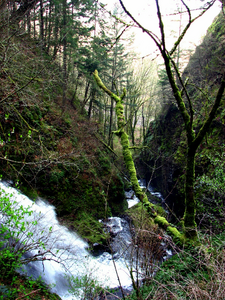
From the parking lot, a short path leads into a canyon into which the Young's Creek with the Sheppards Dell Falls, a two-tier waterfall, flows. The upper waterfall is 13 m high, the lower 15 m. The canyon is crossed by a bridge on the Historic Columbia River Highway, built in 1913 by engineer KR Billner and listed on the National Register of Historic Places . The bridge is clearly visible from the waterfall. The park area is otherwise in a rocky area and is hardly accessible. East of the park begins the Angel's Rest Trail , a 3.7 km walk to a lookout over the Columbia River Gorge .
Use of the park is free.
history
The Lewis and Clark Expedition rested on the site from April 6 to 8, 1806. The site was owned by dairy farmer George D. Shepperd . He donated it to the City of Portland in 1915 in memory of his late wife. The city later gave the land to the state. Between 1940 and 1984 the park area was expanded to its present size through donations, purchases and land swaps.
literature
- Jan Bannan: Oregon State Parks. A complete Recreation Guide. Mountaineers Books, 2nd edition. Seattle 2002, ISBN 978-0-89886-794-7
Web links
- Oregon State Parks: Shepperd's Dell State Park
- Park's website
- Shepperd's Dell State Park on the United States Geological Survey's Geographic Names Information System
Individual evidence
- ^ North West Waterfallsurvey: Sheppards Dell Falls. Retrieved August 18, 2011 .


