The Cove Palisades State Park
|
The Cove Palisades State Park
|
||
|
View from the Tam-a-lau Trail onto Lake Billy Chinook , with The Island peninsula in the center of the picture |
||
| location | Jefferson County in Oregon (USA) | |
| surface | 1781 ha | |
| Geographical location | 44 ° 36 ' N , 121 ° 17' W | |
|
|
||
| administration | Oregon Parks and Recreation Dept. | |
The The Cove Palisades State Park is located in the High Desert in Jefferson County in the US state of Oregon . The 1,781-acre state park is 15 miles southwest of Madras on the shores of Lake Billy Chinook .
geography
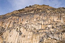
The three rivers Deschutes River , Metolius River and Crooked River are dammed up by the Round Butte Dam to Lake Billy Chinook. The three-armed reservoir fills a canyon surrounded by steep basalt columns , has a size of over 16 km², almost 116 km of shore length and is up to 120 m deep. The state park extends along the banks of the Deschutes and the Crooked River arm of the reservoir.
Geologists suspect that 10–12 million years ago the rivers of that time were diverted in a north-south direction due to lava flows through volcanic eruptions in the cascade chain. These rivers carried numerous sediments of ash, slag and lava with them, which were deposited in a large basin in the area. Three million years ago, this depression, known as The Deschutes Formation , was covered by lava flowing from other volcanoes in the Cascade Range. This cover, known as Bimrock Basalt , is easily noticeable in the park today at the top of the cliffs. Water erosion and volcanic activity have shaped the canyons and vertical cliffs visible today.
Flora and fauna
The park is located in the High Desert, whose vegetation consists of juniper and sagebrush , among other things . Some golden and bald eagles live in the area of the reservoir all year round, between January and March the area is winter quarters for numerous bald eagles. Rattlesnakes are also found in the park area . The narrow peninsula The Island between the Deschutes and Crooked Rivers is an originally preserved area of the High Desert. Eagles and other birds of prey nest on the 80 hectare plateau. The area was declared a Research Natural Area in 1986 and has been closed to visitors since 1997. Numerous fish species such as sockeye salmon , largemouth bass , black bass and several types of trout, especially bull trout , live in the reservoir and in the rivers .
history
In 1878, Clark Green Rogers , one of the first settlers in the region, named a swimming area in the Crooked River "The Cove". In 1940, the state acquired the site and established The Cove State Park with a campground there. Until 1977 the area of the park was enlarged through further donations and purchases, which is why the park was given the name Palisades after the palisade-like basalt columns of the canyon. The original site of the park was flooded by the construction of the dam, so that the current areas of the park are on the plateau above the canyon. The reservoir was named after the Wasco Indian Billy Chinook, who served as a scout for the explorer and US officer John C. Frémont in 1843 .
Ship Rock , a massive basalt rock block with prehistoric rock carvings with mysterious symbols, is located near the group campground. The rock was originally in the canyon and was moved to its current location when the reservoir was built.
Tourist facilities
There is a fee to visit the park. On a cliff above the Deschutes River and the Crooked River, there are two campsites with three holiday homes, three group tent sites and over 250 parking spaces. For day visitors, there are three leisure and recreation areas, one on the arm of the Crooked River and two on the Deschutes River. Each has a boat ramp, mooring, sandy beach, picnic area, and bathroom facilities. At the reservoir there is a marina with boat moorings, a restaurant and a camping shop. The lake is used for numerous water sports such as sailing, water skiing and kayaking. You can fish all year round in the Crooked and Deschutes Rivers. Several hiking and walking trails lead through the park. The Tam-a-lau Trail , an eleven-kilometer circular route that leads from the canyon over the plateau, starts from the Upper Deschutes Day Use Area . Tam-a-lau is a term from the language of the Native Americans and means "place of the big stones".
The park is visited annually by about 80,000 campers and half a million day visitors, making it one of the most popular recreational areas in Oregon. In addition to water sports, the reservoir is primarily used to generate electricity. To the north of the Metolius arm of the lake lies the Warm Springs Reservation, the area of which cannot be entered without a permit.
literature
- Jan Bannan: Oregon State Parks: A complete Recreation Guide . Seattle, Mountaineers, 2nd Edition 2002, ISBN 978-0-89886-794-7
Web links
- Oregon State Parks: The Cove Palisades State Park
- State Park brochure ( Memento from July 19, 2004 in the Internet Archive ) (PDF; 402 kB)
- The Cove Palisades State Park on the United States Geological Survey's Geographic Names Information System
Individual evidence
- ↑ History of the Tam-a-láu Trail ( Memento from October 28, 2005 in the Internet Archive )
- ^ New Marina Operator chosen for The Cove Palisades. Retrieved April 1, 2011 .


