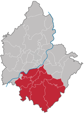
City area south (Plauen)
|
City area south City area of Plauen |
|
|---|---|
| Coordinates | 50 ° 29 '0 " N , 12 ° 8' 30" E |
| surface | 33.3 km² |
| Residents | 11,154 (Dec 31, 2006) |
| Population density | 335 inhabitants / km² |
| Postcodes | 08523, 08527, 08529 |
| structure | 9 districts |
The southern urban area is one of five urban areas in the city of Plauen in Saxony . It is divided into nine districts.
The city area is traversed by the White Elster , and the Kemmler and Galgenberg , the highest mountain in the city , are also located here . The city's second largest train station, the Lower Train Station, is also located here. Otherwise there are mostly houses and forests.
Districts
| district | District number | District key | Postcodes | Area [m²] As of December 31, 2011 |
Remarks |
|---|---|---|---|---|---|
| Hofer suburb | 401 | 08523, 08527 | |||
| Messbach | 402 | 6936 | 08527 | 2,966,104 | Incorporated in 1994 |
| Oberlosa | 403 | 0504 | 08527 | 7,126,591 | Incorporated in 1950 |
| East suburb | 404 | 08527 | |||
| Reinsdorf | 405 | 0509 | 08527, 08529 | 3,063,407 | Incorporated in 1949 |
| Stony | 406 | 0513 | 08527 | 1,949,563 | Incorporated in 1950 |
| Südvorstadt | 407 | 08527 | |||
| Thiergarten | 408 | 0515 | 08523, 08527 | 2,539,943 | Incorporated in 1950 |
| Unterlosa | 409 | 0516 | 08527 | 6,852,250 | Incorporated in 1950 |
Source: Official statistical report of the City of Plauen 2012
Individual evidence
- ↑ Official statistical report of the city of Plauen 2012. (PDF; 5,340 kB) Retrieved on February 28, 2013 .
Web links
- Meßbach in the Digital Historical Directory of Saxony
- Oberlosa in the Digital Historical Directory of Saxony
- Reinsdorf in the Digital Historical Directory of Saxony
- Stöckigt in the digital historical place directory of Saxony
- Thiergarten in the Digital Historical Directory of Saxony
- Unterlosa in the Digital Historical Directory of Saxony


