Reinsdorf (Plauen)
|
Reinsdorf
City of Plauen
Coordinates: 50 ° 28 ′ 35 ″ N , 12 ° 8 ′ 37 ″ E
|
|
|---|---|
| Area : | 3.06 km² |
| Residents : | 715 (Dec. 31, 2002) |
| Population density : | 234 inhabitants / km² |
| Incorporation : | 1949 |
| Postcodes : | 08527, 08529 |
| Area code : | 03741 |
|
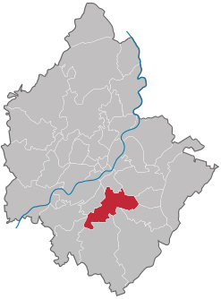
Location of Reinsdorf in Plauen
|
|
Reinsdorf is a district of Plauen in the south urban area , which was incorporated in 1949.
geography
Reinsdorf is located in the southern center of Plauen and borders on nine other districts of Plauen.
| Südvorstadt | East suburb | Reusa with Sorga |
| Thiergarten |

|
Swap joke |
| Messbach | Oberlosa , Unterlosa | Stony |
The area of the district consists of 54.3% agricultural land and 35.0% forest . The remaining area is streets, residential and industrial areas.
history
The place was mentioned in 1263 as Abecz de Reynoldesdorf . It was a manor estate with rows of houses in the block corridor . Reinsdorf belonged to the Plauen office until the 19th century . The community later belonged to the Plauen administration , which was later renamed "Landkreis Plauen". In 1949 it was incorporated into the then still independent city of Plauen .
Population development
Development of the population:
|
|
|
Web links
Commons : Reinsdorf - Collection of images, videos and audio files
Wikisource: Manors and castles in the kingdom of Saxony: Reinsdorf - sources and full texts
- Reinsdorf in the Digital Historical Directory of Saxony
Individual evidence
- ^ A b Gerd Kramer: Stadtentwicklung Plauen , page 64–65 in: Brigitte Unger, Werner Pöllmann u. a. (Ed.): The Vogtland Atlas. Regional atlas on nature, history, population, economy and culture of the Saxon Vogtland . 3. Edition. Verlag Klaus Gumnior, Chemnitz 2007, ISBN 978-3-937386-18-8
- ↑ Historical place directory of Saxony
- ^ Population numbers of Reinsdorf until 1946 in the digital historical place directory. Retrieved March 6, 2013 .


