Starnin
Starnin (German Sternin ) is a village in the West Pomeranian Voivodeship in Poland . It is located in the area of the Gmina Rymań (rural community Roman) and belongs with this to the powiat Kołobrzeski (Kolberg district) .
Geographical location
The village is located in Western Pomerania , about 85 kilometers northeast of Stettin and about 25 kilometers southwest of Kołobrzeg (Kolberg) . The surrounding area consists of forests, fields and meadows. The nearest neighboring town is Kinowo (Kinow), about 1 kilometer to the north .
South of the village are the silted up Small Lake and the Large Lake . The Great Lake drains south into the Mołstowa (Molstow), which flows from east to west about 2 kilometers south of the village . This takes up the Ückerbach , which flows from northeast to southwest , to the southwest of the village, near the Bębnikąt residential area (Kölpiner mill) .
history
The area, in which the village Sternin later emerged, belonged in the middle of the 13th century to the Riman heathland ("desertum, quod vocatur Riman"), which Duke Wartislaw III. von Pomerania donated to the newly founded Marienbusch monastery in 1240 .
The village itself was first mentioned in a document with the place name Starnin in 1269 , in a confirmation of ownership from Duke Barnim I for the Belbuck monastery . In the meantime, the village must have been founded and ownership must have passed from Marienbusch Monastery to Belbuck Monastery. When a parish church was established in the neighboring village of Kienow in 1310 , Heinrich von Wacholz , Bishop of Cammin, assigned the village of Sternin to its new parish. The church in Kienow was probably abandoned during the Reformation.
In modern times, Sternin appeared as a feudal manor of the Manteuffel family . The Manteuffel family had been wealthy in this area, the Terra Culpin , since the Middle Ages . Her Kölpin Castle was in the neighborhood, on the southern bank of the Molstow; it was destroyed in 1432 in a feud with the Abbot of Belbuck .
Sternin is recorded on the Lubin map of the Duchy of Pomerania (1618) . In the 17th century, before the Thirty Years War, the small manor Jäglin was laid out on the southern edge of the Feldmark von Sternin . In Ludwig Wilhelm Brüggemann's detailed description of the current state of the Royal Prussian Duchy of Western and Western Pomerania (1784) Sternin is listed among the noble estates of the Greiffenberg district . At that time, Sternin owned two farms, two shepherds, nine farmers, two half-farmers, a kossät, a blacksmith's shop, a schoolmaster and two wood-keepers' cottages, a total of 27 households (“fire places”). Furthermore, Sternin owned half the share in the Kölpiner mill . In Sternin there was a church that was a subsidiary of the church in Reselkow . The neighboring Kienow belonged to Sternin as a farm and sheep farm from early modern times.
During the separation in the 19th century (after 1846) the Vorwerke Groß Seebeck , Klein Seebeck and Eichhof as well as Knakenkaten and two other wood-keepers' cottages were separated from Sternin and assigned to the newly formed community of Popiel-Seebeck .
Sternin was in 1818 from the Greifenberg county in the county principality reclassified. When the Fürstenthum district was dissolved in 1871, Sternin joined the Colberg-Cörlin district .
Around 1880, the two owners of the Sternin manor divided the estate. Rudolf v. Manteuffel received a star, Louis v. Manteuffel received Kienow, which became an independent estate. But the Sternin manor was already sold in 1890. The buyer then had the property partially divided up in 1891/1892. With this division, 27 new farm positions were created. What was left was a so-called residual material with an area of 425 hectares.
In the 19th century the Sternin manor and the rural rural community Sternin existed side by side. During the division in 1891/1892, the newly created farm positions were assigned to the rural community and the manor district was reduced accordingly. Furthermore, after the division of Sternin and Kienow, a separate manor district of Kienow was formed.
In a second step, the remnants of 1895/1901 were completely divided into farms. These farms were not incorporated into the Sternin rural community. Rather, instead of the remaining manor district, a separate rural community Neu Sternin was formed. It was not until 1923 that the rural community of Neu Sternin was incorporated into the Sternin community.
After the neighboring Kienow was also settled, the local manor district was also dissolved and, after 1923, incorporated into the rural community of Sternin.
After the Second World War , Sternin came to Poland, as did all of Western Pomerania. The population was driven out . The Polish place name was set as Starnin , which also corresponds to the oldest documented place name.
Development of the population
- 1816: 287 inhabitants
- 1855: 360 inhabitants
- 1864: 419 inhabitants
- 1885: 417 inhabitants (including 145 in the rural community of Sternin and 272 in the Sternin manor)
- 1905: 524 inhabitants (of which 144 in the rural community of Sternin and 380 in the rural community of Neu Sternin; after the separation of the manor district of Kienow)
- 1925: 718 inhabitants (after the merger of the rural communities Sternin and Neu Sternin and incorporation of the Kienow estate)
- 1939: 829 inhabitants
- 2013: 232 inhabitants
church
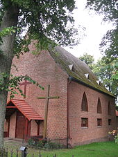
The predecessor of today's church building was a half-timbered building from the 18th century. The church was decorated with wooden epitaphs belonging to the Manteuffel family , which are now exhibited in the Kołobrzeg City Museum .
The previous building was demolished around 1930 and a modern church was built in its place, which was consecrated as a Protestant church in 1932 . The church was built without a steeple, this was planned for later.
Today the church building is used by the Polish Catholic Church.
Administrative structure
Today Starnin forms a Schulzenamt in the Gmina Rymań (rural community Roman) . The Bębnikąt residential area (Kölpiner Mühle) also belongs to the Schulzenamt .
See also
literature
- Manfred Vollack : The Kolberger Land. Its cities and villages. A Pomeranian homeland book. Husum Druck- und Verlagsgesellschaft, Husum 1999, ISBN 3-88042-784-4 , pp. 652-663.
Web links
- Star on the website of the Kolberger Lande association
Footnotes
- ^ Klaus Conrad (arrangement): Pommersches Urkundenbuch . Volume 1. 2nd edition (= publications of the Historical Commission for Pomerania. Series 2, Vol. 1). Böhlau Verlag, Cologne / Vienna 1970, No. 378, footnote 16.
- ↑ Rodgero Prümers (arrangement): Pommersches Urkundenbuch . Volume 2, 1st section. Stettin 1881, no.882.
- ↑ Ludwig Wilhelm Brüggemann : Detailed description of the current state of the Königl. Prussian Duchy of Western and Western Pomerania . Part II, Volume 1, Stettin 1784, pp. 452–453 No. 85. ( Online )
- ^ Manfred Vollack : The Kolberger Land. Its cities and villages. A Pomeranian homeland book. Husum Druck- und Verlagsgesellschaft, Husum 1999, ISBN 3-88042-784-4 , p. 548.
- ↑ a b c d e f g Manfred Vollack : The Kolberger Land. Its cities and villages. A Pomeranian homeland book. Husum Druck- und Verlagsgesellschaft, Husum 1999, ISBN 3-88042-784-4 , p. 656.
- ^ Statystyka ludności gminy Rymań .
- ^ Website of the municipality (accessed on February 15, 2014).
Coordinates: 53 ° 58 ' N , 15 ° 27' E


