
Administrative division of Croatia
The administrative division of Croatia is the vertical administrative structure of the Republic of Croatia .
construction
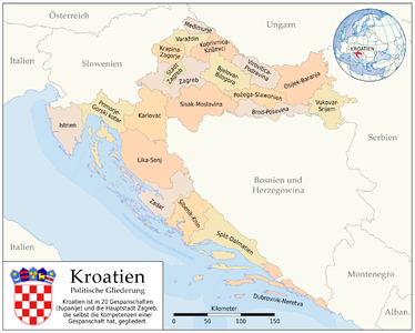
Below the national level there are 20 regional self-government units ( Croatian županija , plural županije , German “ County ” or “ County ”) as well as the capital Zagreb , which itself has the status of a county. These units correspond to the third level (NUTS-3) of the EU territorial classification NUTS .
The 21 units (including the city of Zagreb) are grouped into the following two regija (statistical regions, NUTS 2 level):
- HR03: Jadranska Hrvatska (Adriatic Croatia)
- HR04: Kontinentalna Hrvatska (Continental Croatia)
These regions have no regional authority character.
The second administrative level is made up of the 546 Gradovi i općine (cities and municipalities) that correspond to LAU-2 (LAU-1 is not occupied).
- cards
Croatian counties
Individual preview of the counties
.png)

Counties ( Županije )
Summary table of Croatian Županije
The counties are named partly after the capital, partly after landscape terms.
| No. | flag | coat of arms | Županija | German name | map | Area in km² |
Residents 1 | Density 2 | Administrative headquarters | NUTS 3 code 3 |
|---|---|---|---|---|---|---|---|---|---|---|
| 1 |
|
|
Zagrebačka županija | Zagreb County |

|
3,078 | 317,606 | 103 | Zagreb | HR042 |
| 2 |
|
|
Krapinsko-zagorska županija | Krapina-Zagorje County |

|
1,230 | 132,892 | 108 | Krapina | HR043 |
| 3 |
|
|
Sisačko-moslavačka županija | Sisak-Moslavina County |

|
4,448 | 172,439 | 39 | Sisak | HR04E |
| 4th |
|
|
Karlovačka županija | Karlovac County |

|
3,622 | 128,899 | 36 | Karlovac | HR04D |
| 5 |
|
|
Varaždinska županija | Varaždin County |

|
1,260 | 175,951 | 140 | Varaždin | HR044 |
| 6th |
|
|
Koprivničko-križevačka županija | Koprivnica-Križevci County |

|
1,734 | 115,584 | 67 | Koprivnica | HR045 |
| 7th |
|
|
Bjelovarsko-bilogorska županija | Bjelovar-Bilogora County |

|
2,638 | 119.764 | 45 | Bjelovar | HR047 |
| 8th |
|
|
Primorsko-goranska županija |
Primorje-Gorski kotar County (Coastal Country - Mountainous Country) |

|
3,590 | 296.195 | 83 | Rijeka | HR031 |
| 9 |
|
|
Ličko-senjska županija | Lika-Senj County |

|
5,350 | 50,927 | 10 | Gospić | HR032 |
| 10 |
|
|
Virovitičko-podravska županija | Virovitica-Podravina County |

|
2,021 | 84,836 | 42 | Virovitica | HR048 |
| 11 |
|
|
Požeško-slavonska županija | Požega-Slavonia County |

|
1,821 | 78.034 | 43 | Požega | HR049 |
| 12 |
|
|
Brodsko-posavska županija | Brod-Posavina County |

|
2,027 | 158,575 | 78 | Slavonski Brod | HR04A |
| 13 |
|
|
Zadarska županija | Zadar County |

|
3,643 | 170.017 | 47 | Zadar | HR033 |
| 14th |
|
|
Osječko-baranjska županija | Osijek-Baranja County |

|
4.149 | 305.032 | 74 | Osijek | HR04B |
| 15th |
|
|
Šibensko-kninska županija | Šibenik-Knin County |

|
2,994 | 109,375 | 37 | Šibenik | HR034 |
| 16 |
|
|
Vukovarsko-srijemska županija | Vukovar-Syrmia County |

|
2,448 | 179,521 | 73 | Vukovar | HR04C |
| 17th |
|
|
Splitsko-dalmatinska županija | Split-Dalmatia County |

|
4,524 | 454.798 | 101 | Split | HR035 |
| 18th |
|
|
Istarska županija | Istria County |

|
2,813 | 208.055 | 74 | Pazin | HR036 |
| 19th |
|
|
Dubrovačko-neretvanska županija | Dubrovnik-Neretva County |

|
1,782 | 122,568 | 69 | Dubrovnik | HR037 |
| 20th |
|
|
Međimurska županija | Međimurje County |

|
730 | 113,804 | 156 | Čakovec | HR046 |
| 21st |
|
|
Degree Zagreb | City of Zagreb |

|
640 | 790.017 | 1234 | Zagreb | HR041 |
| total | 56,542 | 4,284,889 | 76 |
- 1 2011 census
- 2 Population density in inhabitants per km²
- 3 The first four code digits show the NUTS 2 code of the superordinate region
Institutions
Each county has an elected 'county assembly ' (Croatian Županijska skupština ). At the head of the 'County Government ' (Croatian Županijsko poglavarstvo , literally: 'County Main Team ') is the ' Gespan ' (Croatian Župan ), who is elected by the County Assembly and confirmed by the President.
The counties are divided into 122 cities (Croatian grad , plural gradovi ) and 423 municipalities (Croatian općina , plural općine ) (figures as of March 31, 2001).
Effective range
The counties are responsible for all regional areas that do not fall under the control of higher-level state institutions due to the constitution or other statutory provisions.
The counties can determine the following areas in their sphere of activity:
- education
- health
- Community planning
- Economic development
- Transport and infrastructure
- Maintenance and maintenance of public roads
- Planning and development of educational, health, social and cultural institutions
- Issuance of building permits and Lokacijska dozvola (other permits associated with construction works) as well as the execution of area plans for the area of the county outside of large cities
- other work depending on special laws
history
The current counties were formed in 1992 on the basis of the provisions of the 1990 Constitution. The new counties and the new cities and municipalities formed within them replaced the 102 (large) municipalities that had previously existed. The boundaries of the counties have only changed in a few cases since then. In the course of the accession negotiations with the EU since 2006, the statistical authority EUROSTAT carried out a classification according to the NUTS methodology and initially defined four regions as NUTS 2 regions. Since April 2007 it has been clear that Croatia will be divided into three statistical regions for the EU authorities, since according to the latest regulation each statistical region must have a population share of at least 800,000 inhabitants.
See also
Web links
- Croatian Government - Information on local and regional self-government in Croatia
- Statistical regions of the EU
Individual evidence
- ↑ DZS Croatian Bureau Of Statistics (Ed.): Census of Population, Households and Dwellings 2011, Population by Sex and Age . 2013, ISSN 1333-1876 , p. 54 ff . (English, dzs.hr [PDF; 13.3 MB ; accessed on January 25, 2019]).

Albania | Belgium | Bosnia and Herzegovina | Bulgaria | Denmark | Germany | Estonia | Finland | France | Greece | Ireland | Iceland | Italy | Kazakhstan | Croatia | Latvia | Liechtenstein | Lithuania | Luxembourg | Malta | Moldova | Montenegro | Netherlands | North Macedonia | Norway | Austria | Poland | Portugal | Romania | Russia | San Marino | Sweden | Switzerland | Serbia | Slovakia | Slovenia | Spain | Czech Republic | Turkey | Ukraine | Hungary | United Kingdom | Belarus
Administrative division of the States of:
Africa |
Asia |
Australia and Oceania |
Europe |
North and South America