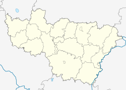
Stavrovo
| Urban-type settlement
Stavrovo
Stavrovo
|
||||||||||||||||||||||||||||||||||||||
|
||||||||||||||||||||||||||||||||||||||
|
||||||||||||||||||||||||||||||||||||||
Stavrovo ( Russian Ставро́во ) is an urban-type settlement in the Vladimir Oblast in Russia with 7800 inhabitants (as of October 14, 2010).
geography
The place is about 25 km as the crow flies west of the city center of the Vladimir Oblast Administrative Center . It is located on the right bank of the left Klyazma -Nebenflusses Kolokscha .
Stavrowo belongs to the Sobinski district , is located a good 15 km north of the Sobinka district center and is the seat and only locality of the municipality (gorodskoje posselenije) Possjolok Stavrovo.
history
The place was first mentioned in 1515 as the property of the Moscow Grand Dukes (at that time Vasily III ). In 1650 it belonged to the property of the Moscow Ascension Monastery (Voznesensky monastyr). The original place name was Krestowo, from Russian krest for " cross ;" later it was changed to Stawrowo , derived from Greek σταυρός (staurós) with the same meaning .
In the 19th century, like many other places in the region, Stawrowo developed into a center of the textile industry.
From January 14, 1929 to 1932, Stawrowo was the first administrative seat of the Stavrowski rajon, part of the industrial oblast Ivanovo ; again from March 27, 1945 as part of the Vladimir Oblast formed in 1944. In 1946, a supplier company for the automotive industry started production, which is still the most important company in the town today. On February 19, 1958, the place received the status of an urban-type settlement. On January 12, 1965, the Rajon in the Sobinski rajon went up.
Stavrovo is included in the list of historical cities of Russia (expanded version from 2002).
Population development
| year | Residents |
|---|---|
| 1959 | 3252 |
| 1970 | 5122 |
| 1979 | 6673 |
| 1989 | 7985 |
| 2002 | 8005 |
| 2010 | 7800 |
Note: census data
traffic
Stavrovo is bypassed to the southwest by regional road 17A-2, which branches off about 10 km southeast of the federal highway M7 Volga Moscow - Nizhny Novgorod - Ufa and continues through the western part of the oblast via Kolchugino and Alexandrov to the federal highway M8 Cholmogory near Sergiev Posad .
The nearest train station is a good 12 km southeast of Kolokscha at 173 km of the Moscow - Nizhny Novgorod - Kotelnitsch line that was opened on this section in 1861 .
Web links
Individual evidence
- ↑ a b Itogi Vserossijskoj perepisi naselenija 2010 goda. Tom 1. Čislennostʹ i razmeščenie naselenija (Results of the All-Russian Census 2010. Volume 1. Number and distribution of the population). Tables 5 , pp. 12-209; 11 , pp. 312–979 (download from the website of the Federal Service for State Statistics of the Russian Federation)


