Steinlah
|
Steinlah
Haverlah Parish
Coordinates: 52 ° 4 ′ 31 ″ N , 10 ° 19 ′ 46 ″ E
|
|
|---|---|
| Height : | approx. 160 m above sea level NN |
| Residents : | 622 (Nov. 30, 1998) |
| Incorporation : | March 1, 1974 |
| Postal code : | 38275 |
| Area code : | 05341 |
|
Location of Steinlah in the Haverlah municipality
|
|
|
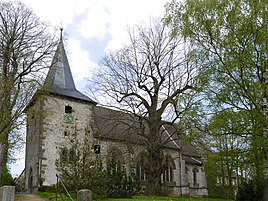
Church of St. Catherine of Steinlah
|
|
Steinlah is a district of the municipality Haverlah , which belongs to the joint municipality Baddeckestedt in the district of Wolfenbüttel in Lower Saxony.
geography
The following places surround Steinlah:
- Gebhardshagen in the northeast
- Engerode and Calbecht in the east-northeast
- Beinum in the east
- Salzgitter-Bad in the southeast
- Haverlah in the south
- Söderhof and Sehlde in the southwest
- Klein Elbe in the west
- Groß Elbe in the west north-west
- Gustedt in the northwest
Steinlah is located on the western edge of the northern central part of the Salzgitter ridge .
history
The area around Steinlah had already been visited by people in the Neolithic Age, which tool finds prove.
It is believed that the place Steinlah was formed during the Great Migration in the 3rd to 5th centuries AD. From here, the Hellweg, which ran through the Salzgitter ridge and led to the brine springs in today's Salzgitter-Bad, was secured . However, the first documented mention of the village comes from the year 1239. Steinlah was created on a previously wooded area and developed from a farm to the knight's seat of the Lords of Steinlah, who can be traced back to 1311. Up to this point in time and beyond, several farms were liable to the landlords; this later included aristocratic families, monasteries and churches in the area.
Only after the village of Grundstedt in the west of Steinlah, first mentioned in 1146, was given up around 1350, the Gutsort Steinlah developed into a farming village. At least since the 15th century the village belonged to the duchy of Hildesheim . Through the Hildesheim collegiate feud from 1519 to 1523 it came to the Principality of Braunschweig-Wolfenbüttel , to which it belonged until 1643.
In 1654 a teacher is mentioned in Steinlah. In 1739 the school burned down. After it was rebuilt, a new building had to give way in 1848, which was enlarged in 1889. The building of the last school, which was finally closed in 1980, opened in 1951.
Up until the 1930s, canaries were bred in Steinlah , which were mainly sold to America.
Mill
Steinlah's mill was built on a hill southwest of the village after the Thirty Years War . At first it was a post mill , which was later replaced by a Dutch mill . In 1936 the mill lost its wings due to a lightning strike, but it is still the location of a craft business.
Mining
church
The tower of St. Catherine's Church in Steinlah dates from 1447. However, the nave had to be renewed in 1867 and is 420 years younger. The Gothic baptismal font, however, is older than the church tower.
A Protestant pastor can be found in the village since the Reformation.
Culture and sights
Ark Village
In Steinlah, a number of animal owners are breeding old breeds of domestic animals, several of which are endangered and are therefore on the Red List of the Society for the Conservation of Old and Endangered Domestic Animal Breeds (GEH).
The following breeds are kept:
- Horse : Rhenish-German draft horse
- Cattle : Original Braunvieh , Red Höhenvieh
- Sheep : Rauhwolliges Pommersches Landschaf , Coburg Fuchsschaf
- Goats : Harz goat
- Dogs : yellow cheek , Harzer Fuchs (old German herding dog)
- Geese : Leine goose , Diepholzer goose
- Duck : Pomeranian Duck
- Chickens : Bergische Kräher , Lakenfelder , Deutsches Reichshuhn , Altsteirer .
The GEH gave the project the name Arche-Dorf .
Economy and Infrastructure
Transport links
The county road 81 leads through Steinlah, which connects the village with the federal road 6 and Haverlah in the south as well as with the state road 670 between Gustedt and Gebhardshagen.
The nearest train stations are in Baddeckestedt on the Hildesheim – Goslar line and in Salzgitter-Bad on the Braunschweig – Salzgitter-Bad line .
Personalities
- Justus Erich Walbaum (1768–1837): type founder and inventor of the Walbaum letters
- Franz Anton Erich Moritz Müller (1791–1858): copperplate engraver and professor at the Dresden Art Academy
literature
- Friedrich-Karl Krentel and Gunnar Söffge: Local family book Steinlah 1628 - 1875 with farm book 1525 - 1870 . Hanover: Lower Saxony Regional Association for Family Studies 2013 (= Edition Family Studies Lower Saxony 13)
swell
To the history section :
- Website of the municipality of Baddeckestedt (short chronicle by Wilfried Bartels).
- Samtgemeinde Baddeckestedt (Ed.): 25 years of the Samtgemeinde Baddeckestedt - 1974–1999. Festschrift ; 1999 (pp. 27/28).
Individual evidence
- ↑ Steinlah on the website of the Samtgemeinde Baddeckestedt , accessed on March 28, 2018.
- ↑ Internet site of the Arche-Dorf Steinlah , accessed on May 18, 2015.
- ↑ GEH website , accessed on May 18, 2015.


