Slunj
| Slunj | ||
|
||
|
|
||
| Basic data | ||
|---|---|---|
| State : |
|
|
| County : |
|
|
| Height : | 258 m. i. J. | |
| Area : | 392.54 km² | |
| Residents : | 5,076 (2011) | |
| Population density : | 13 inhabitants per km² | |
| Telephone code : | (+385) 047 | |
| Postal code : | 47 240 | |
| License plate : | KA | |
| Structure and administration (status: 2014) |
||
| Community type : | city | |
| Mayor : | Jure Katić ( HDZ ) | |
| Postal address : | Trg dr. Franje Tuđmana 12 47 240 Slunj |
|
| Website : | ||
| Others | ||
| Patron saint : | Holy Trinity (Sv. Trojstvo) | |
| City Festival : | Trinity | |
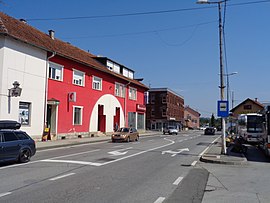
 Radić Brothers Street in the city center |
||
Slunj [ ˈsluɲ ] ( Hungarian Szluin , German outdated Sluin or occasionally Slazuin , Latin Slovin ) is a city in central Croatia . It is located 50 km south of Karlovac and 30 km from the Plitvice Lakes National Park .
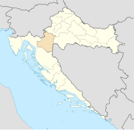
Slunj is the center of the Kordun region on the Upper Korana , in the border area with Bosnia and Herzegovina . The town has 5,076 inhabitants (census 2011 ) and is part of the Karlovac County .
The Rastoke district is known for being a smaller version of the Plitvice Lakes. Here the Slunjčica river branches into many smaller river arms and flows over numerous cascades and smaller waterfalls into the Korana . Many old watermills can also be visited.
history
In the early modern period, the area around Slunj was an unsafe border region between Europe and the Ottoman Empire . The fortified town of Slovin of the Frankopans (ung. Frangépan), a Croatian noble family, served as the last fortress . Later this town was called Slunj.
In 1548 the Turks suffered a defeat here. In the 1550s years the surrounding area has been repeatedly hit by Ottoman troops, with the 1567 to Banus of Croatia and Slavonia appointed Franjo Slunjski Frankopan great contributions in defending acquired.
In 1578 Slunj fell into the hands of the Ottomans for a short time. The old fortress was burned down but rebuilt over time.
At the end of 1584 the captain of the Croatian military border Josef Thurn and the Croatian ban Tamás Erdődy brought the Ottoman army commanded by Beylerbey of Buda, Ferhad Pascha Sokolović , a heavy defeat at Slunj (see also Siege of Gvozdansko ).
Since the end of the 16th century the place was an important base of the military border (Karlstädter Generalat ) and served to secure the border area to the Ottoman Empire. The castle was expanded into a fortress and served the commanding general of this area as an official seat (see castle ruins Stari grad Slunj ). After the Peace of Sistowa in 1791, the area began to be more populated.
Slunj experienced an economic boom during the brief French rule from 1809 to 1813, when urban roads, warehouses and mills were built, vineyards were planted and mulberry trees were planted. During this time, Croatian was also made the official language of the country. The residence of the then governor general of the French province of Illyria , Marshal Auguste Frédéric Louis Viesse de Marmont , still exists today.
The first written mention of the city was left by the well-known chronicler Baron Johann Weichard Valvasor , who reported in 1689 about the fortified city of Slunj itself, a bridge and a mill. The first depiction of the Rastoke mills dates from 1789; it is a Rastoke engraving that accompanies a description by Belshazzar Hacquet . “The area around Slunj is downright romantic […] and is crowned by the magnificent Slunjčica waterfalls, which will enchant or astonish everyone, even if they are not outspoken nature lovers. Yes, Slunj with its romantic surroundings and the silver waterfalls of Slunjčica is such a gem of nature that even strangers are jealous of it. ”(S. Širola).
The Austrian writer Heimito von Doderer published the novel " The Slunj Waterfalls " in 1963 , which is mainly set in the 19th century. In the 20th century a scientific study of the area around Slunj and the Rastoke district began . In the 19th and early 20th centuries, the Rastoke were the center of social life in this area. With the development of the electric mills and a massive emigration movement after World War II, the economic importance of the mills in Rastoke decreased drastically.

Attractions
At Slunj, the Slunjčica River (also called Slušnica by the locals ) plunges over numerous waterfalls into the Korana . This is where the 22 Rastoke watermills (which actually means “river branching”) from the 18th century stood or still stand , which served as grain mills for the entire region.
tourism
Tourism in this poor region of Croatia is slowly starting to gain a foothold again. The area around Slunj offers excellent hunting opportunities and is a magnet for many hobby fishermen. Slunj also has a very popular, natural bathing area on the Korana.
Slunj bridges

In view of the topography of Slunj and in particular the importance of the historic town center of Rastoke , as well as the location of Slunj along the north-south traffic connection, which is very important for Croatia, numerous important bridge projects were implemented in Slunj early on. As early as 1689 the polyhistor Johann Weichard Valvasor mentioned a bridge near Slunj. In 1825 a more modern north-south road connection including two bridges at Slunj was realized. These bridges still exist today. Bridges have always been a characteristic symbol of Slunj. The annual review of the Catholic Slunjer deanery therefore also bears the name "Mostovi" (for bridges kroat.).
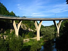
The nationally significant project of a new connection was realized in 1958 with the construction of a new bridge over the Korana. Architect Kruno Tonković designed a reinforced concrete road bridge that leads past the idyllic Rastoke district in a sharp curve . Tonković was ahead of his time with this architectural work. The bridge is still an integral part of the D1 national road , which connects southern Croatia, the Plitvice Lakes, with the interior of the country. The bridge offers excellent views of the Rastoke mills and waterfalls and spans the Korana canyon. In view of the curve, it fits nicely into the landscape. The arch of the bridge has a radius of 71 m. The average angle is 160 degrees. The road connection over this bridge is completed by an additional bridge over the Slunjčica River , which was also built in 1958. In August 1995, in the course of the Croatian War, the bridge over the Korana was partially damaged when it was blown up by Serbian militants when leaving the city. However, the bridge was opened to traffic a few weeks later.
sons and daughters of the town
- Milan Neralić (important fencer and bronze medalist at the Summer Olympics in Paris 1900 )
Town twinning
-
 Castel San Giovanni , Italy
See also
- Gothic statue of Our Lady of Slunj (Majka Božja Slunjska) in the votive church of the Trsat pilgrimage site
- List of castles and chateaus in Croatia
- Daniel von Peharnik-Hotkovich
- "Eugen Kvaternik" military training area
Web links
- Official website of the city of Slunj
- Tourist community in Slunj
- Cultural tourism in Croatia. Trinity Church in Slunj. (Croatian)
Individual evidence
- ↑ Hazud.ch. Sveti Ivan Slunjski opet čuva most na Slovinčici (1996) ( Page no longer available , search in web archives ) Info: The link was automatically marked as broken. Please check the link according to the instructions and then remove this notice.
- ↑ Gospičko-senjska Biskupija. Mostovi, godišnjak Slunjskog dekanata (2011) ( Page no longer available , search in web archives ) Info: The link was automatically marked as defective. Please check the link according to the instructions and then remove this notice.


